
Nelson is a city on the eastern shores of Tasman Bay / Te Tai-o-Aorere. Nelson is the oldest city in the South Island and the second-oldest settled city in New Zealand – it was established in 1841 and became a city by royal charter in 1858.

Tasman District is a local government district in the northwest of the South Island of New Zealand. It borders the Canterbury Region, West Coast Region, Marlborough Region and Nelson City. It is administered by the Tasman District Council, a unitary authority, which sits at Richmond, with community boards serving outlying communities in Motueka and Golden Bay / Mohua. The city of Nelson has its own unitary authority separate from Tasman District, and together they comprise a single region in some contexts, but not for local government functions or resource management (planning) functions.

Abel Tasman National Park is a New Zealand national park located between Golden Bay and Tasman Bay / Te Tai-o-Aorere at the north end of the South Island. It is named after Abel Tasman, who in 1642 became the first European explorer to sight New Zealand and who anchored nearby in Golden Bay.
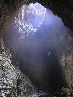
Harwoods Hole is a cave system located in the northwest of the South Island of New Zealand, in the Abel Tasman National Park. At 183 metres (600 ft), it is New Zealand's deepest vertical shaft. It was first explored in 1958, long after it was discovered.

Murchison is a town in the Tasman Region of the South Island of New Zealand. It is near the western end of the "Four Rivers Plain", at the confluence of the Buller River and the Matakitaki River. The other two rivers are the Mangles River, and the Matiri River. It is a rural service town for the surrounding mixed farming district, approximately halfway between Westport and Nelson. Murchison was named after the Scottish geologist Roderick Murchison, one of the founders of the Royal Geographical Society.

Motueka is a town in the South Island of New Zealand, close to the mouth of the Motueka River on the western shore of Tasman Bay / Te Tai-o-Aorere. It is the second largest in the Tasman Region, with a population of 8,280 as of June 2021.

Tākaka is a small town situated at the southeastern end of Golden Bay, at the northern end of New Zealand's South Island, located on the lower reaches of the Tākaka River. State Highway 60 runs through Takaka and follows the river valley before climbing over Tākaka Hill, to Motueka linking Golden Bay with the more populated coast of Tasman Bay / Te Tai-o-Aorere to the southeast. The town is served by Takaka Aerodrome.

Tākaka Hill is a range of hills in the northwest of the South Island of New Zealand. Made of marble that has weathered into many strange forms and with numerous sink holes, it is typical karst country. The marble is Ordovician in age and from the Takaka Terrane.

Onekaka is a rural district on the coast of Golden Bay, between Tākaka and Collingwood, near the northwestern extremity of the South Island of New Zealand.
Takaka County was one of the counties of New Zealand in the South Island.
The Waingaro River is a river of the Tasman Region of New Zealand's South Island.

State Highway 60 is a state highway servicing the far northwest of the South Island of New Zealand. Running between the settlements of Richmond and Collingwood, it is 116 kilometres (72 mi) long and lies entirely within the Tasman District. It is the northernmost highway in the South Island and is a popular tourist route, servicing Motueka, Abel Tasman National Park, Golden Bay, and Farewell Spit.

Golden Bay / Mohua is a shallow, paraboloid-shaped bay in New Zealand, near the northern tip of the South Island. An arm of the Tasman Sea, the bay lies northwest of Tasman Bay / Te Tai-o-Aorere and Cook Strait. It is protected in the north by Farewell Spit, a 26 km long arm of fine golden sand that is the country's longest sandspit. The Aorere and Tākaka rivers are the major waterways to flow into the bay from the south and the west.

The Tākaka Aerodrome serves the town of Tākaka, in the South Island of New Zealand.

Tata Islands are a pair of small uninhabited islands off the north coast of New Zealand's South Island. They are located some 20 kilometres (12 mi) to the northwest of Tākaka in the southeast of Golden Bay close to Abel Tasman Point, and are contained within Abel Tasman National Park. The small settlement of Tata Beach lies on the South Island mainland one kilometre to the south of the islands.

The Ngārua Caves are a series of limestone caves in the Takaka Hill range south of Abel Tasman National Park.
Ngāti Apa ki te Rā Tō is a Māori iwi (tribe) in the upper South Island of New Zealand. Its rohe include the areas around Golden Bay, Tākaka, Tasman Bay / Te Tai-o-Aorere, Motueka, Nelson and Saint Arnaud, including Taitapu and Kawatiri River catchments and Lakes Rotoiti, Rotoroa, and the Tophouse.
Te Atiawa o Te Waka-a-Māui is a Māori iwi (tribe) in the upper South Island of New Zealand. Its rohe extends from Golden Bay and Marlborough Sounds at the top of the South Island to Cape Campbell, St Arnaud and Westport.

Motupipi is a settlement in the Tasman District of New Zealand's upper South Island, located at the mouth of the Motupipi River east of Tākaka.
Patons Rock is a coastal settlement in the Tasman District of New Zealand. It is located in Golden Bay, northwest of Tākaka.

