Guanay is a small town on the Tipuani River in the Yungas region of Bolivia. It is the seat of the Guanay Municipality, the second municipality of the Larecaja Province.
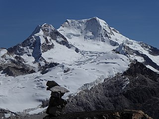
Chachacomani is a mountain in the Cordillera Real of the Andes Mountains, east of Lake Titicaca in Bolivia.
Apolo Municipality is the first municipal section of the Franz Tamayo Province in the La Paz Department, Bolivia. Its seat is Apolo.

Chearoco, Chiaraco or Chiaroco is a mountain in the Cordillera Real in the Andes of Bolivia. It has a height of about 6,127 m (20,102 ft). It is situated in the La Paz Department, Larecaja Province, Guanay Municipality, southeast of the peak of Aman Pata. Chearoco lies between Qalsata in the northwest and Chachakumani in the southeast.
The Movement for Sovereignty is a leftist, indigenist Bolivian political party founded by dissidents of the Movement for Socialism (MAS-IPSP). Its leader, and fourth-place candidate for Governor of La Paz department in the 2010 regional election is Lino Villca. Other MAS-IPSP activists involved in founding the MPS include Óscar Chirinos, Miguel Machaca, and Rufo Calle. The party's colors are blue, white, and yellow.
Calzada is a mountain in the Andes, about 5,874 m (19,272 ft) high, located in the Cordillera Real of Bolivia. It lies in the La Paz Department, Larecaja Province, on the border of the Sorata Municipality and the Guanay Municipality. It is situated south-east of Ancohuma, between the mountain Q'asiri in the north-west and Chearoco in the south-east, and east of San Francisco Lake.
Mullu Apachita is a mountain in the Cordillera Real in the Andes of Bolivia, about 5,368 metres (17,612 ft) high. It is located in the La Paz Department at the border of the Larecaja Province, Guanay Municipality, and the Los Andes Province, Batallas Municipality. It is situated southeast of the mountains Wila Lluxita and Janq'u Uyu.
Pallqa K'ark'a is a 5,046-metre-high (16,555 ft) mountain in the Cordillera Real in the Andes of Bolivia. It is situated in the La Paz Department, Larecaja Province, in the south-west of the Guanay Municipality. Pallqa K'ark'a lies north-east of the mountain Chachakumani at the confluence of the rivers Ch'ijini (Chiquini) and Waraqu (Waraco).
Wari Qalluni Pata is a 5,064-metre-high (16,614 ft) mountain in the Cordillera Real in the Andes of Bolivia. It is situated in the La Paz Department, Larecaja Province, Guanay Municipality, and in the Omasuyos Province, Achacachi Municipality, west of the mountain Ch'iyar Juqhu.
Janq'u Quta is a lake in the Cordillera Real in the Andes of Bolivia. It is located in the La Paz Department, Larecaja Province, in the south-west of the Guanay Municipality. Janq'u Quta lies near the mountain Ch'iyar Juqhu.
Patapatani is a 5,452-metre-high (17,887 ft) mountain in the Cordillera Real in the Andes of Bolivia. It is located in the La Paz Department, at the border of the Larecaja Province, Guanay Municipality, and the Los Andes Province, Batallas Municipality. Patapatani lies between the rivers Qillwani and Chachakumani, north-east of the mountain Wila Wilani.
Kuntur Jipiña is a mountain in the Cordillera Real in the Andes of Bolivia, about 5,260 metres (17,257 ft) high. It is located in the La Paz Department, at the border of the Larecaja Province, Guanay Municipality, and the Los Andes Province, Batallas Municipality. It lies west of the mountain Chachakumani and south-east of Wila Wila. The lakes Janq'u Quta and Jist'aña Quta are situated north-east and north-west of Kuntur Jipiña.
Jach'a Pata is a mountain in the Cordillera Real in the Andes of Bolivia, about 4,940-metre (16,207 ft) high. It is situated in the La Paz Department, Larecaja Province, in the south of the Guanay Municipality. Jach'a Pata lies north-west of the mountain Janq'u K'ark'a and south of the lake Qutapata (Kkota Pata).
Wila Umani is a 4,438-metre-high (14,560 ft) mountain in the Andes of Bolivia. It is located in the La Paz Department, Larecaja Province, Guanay Municipality. Wila Umani lies in the eastern extensions of the Cordillera Real. It is situated south-west of Ch'alluma, north of the river Uma Pallqa.
Ñuñuni Qalani is a mountain in the Andes of Bolivia, about 4,940 metres (16,207 ft) high. It is located in the La Paz Department, Larecaja Province, Guanay Municipality. Ñuñuni Qalani lies in the eastern extensions of the Cordillera Real. It is situated south-east of the river Uma Pallqa and the village of Uma Pallqa.
Turini is a 5,064-metre-high (16,614 ft) mountain in the Cordillera Real in the Andes of Bolivia. It is located in the La Paz Department, Larecaja Province, Guanay Municipality. Turini lies northwest of the river Uma Pallqa and the village of Uma Pallqa. It is situated northeast of Jisk'a Turini.
Aqhuya Aqhuyani is a 5,164-metre-high (16,942 ft) peak in the Cordillera Real in the Andes of Bolivia. It is situated in the La Paz Department, Larecaja Province, Guanay Municipality. Aqhuya Aqhuyani lies northeast of Mullu Apachita and northwest of the village of Uma Pallqa (Uma Palca) and Turini.
Wila Wila is a mountain in the Cordillera Real in the Andes of Bolivia, about 5,240 metres (17,192 ft) high. It is located in the La Paz Department, Larecaja Province, Guanay Municipality. It lies north-west of the mountains Chachakumani and Kuntur Jipiña. The lake Jist'aña Quta lies at its feet, south of it.
Imasiña is a 5,458-metre-high (17,907 ft) mountain in the Cordillera Real in the Andes of Bolivia. It is located in the La Paz Department at the border of the Larecaja Province, Guanay Municipality, and the Los Andes Province, Pucarani Municipality. Imasiña lies northwest of Jisk'a Pata and northeast of Wari Umaña.
Qillwani is a 5,828-metre-high (19,121 ft) mountain in the Cordillera Real in the Andes of Bolivia. It is located in the La Paz Department, Larecaja Province, near the western border of the Guanay Municipality. It lies southeast of Ch'iyar Juqhu, northwest of Chachakumani and northeast of Patapatani.


