
Los Andes is one of the twenty provinces in the central parts of the Bolivian La Paz Department. The province was legally founded on November 24, 1917, during the presidency of José Gutiérrez Guerra. The Spanish name of the province means "The Andes", referring to its position within the Cordillera Real which is part of the Bolivian Andes mountain range. The capital of the province is Pucarani, which has a population of 918 as of the 2001 census. Pucarani is situated in the Altiplano west of the Cordillera Real offering a view of some of its highest mountains such as Ch'iyar Juqhu, Chachakumani, Kunturiri, Wayna Potosí and Chacaltaya.
Pucarani Municipality is the first municipal section of the Los Andes Province in the La Paz Department, Bolivia. Its seat is Pucarani.
Pucarani is a small town in the La Paz Department in Bolivia. It is the seat of the Pucarani Municipality, the first municipal section of the Los Andes Province and of the province.
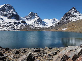
Ch'iyar Quta is a lake in the Cordillera Real of Bolivia situated in the La Paz Department, Los Andes Province, Pucarani Municipality, Huayna Potosí Canton. It is situated at a height of about 4,700 metres (15,400 ft)near the peaks of Kunturiri and east of the lake Juri Quta.
Ch'iyar Quta may refer to:
Laram Quta or Larama Quta may refer to:

Nasa Q'ara is a 5,156-metre-high (16,916 ft) mountain in the Cordillera Real in the Andes of Bolivia. It is located in the La Paz Department, Los Andes Province, Pucarani Municipality. Nasa Q'ara is situated south-west of the mountain Chiqapa and north-east of the mountain Ch'iyar K'ark'a. It lies north of the lake Allqa Quta and south of a small lake named Khunu Quta.
Qullpani is a 4,926-metre-high (16,161 ft) mountain in the Cordillera Real in the Andes of Bolivia. It is located in the La Paz Department, Los Andes Province, Pucarani Municipality. Qullpani lies south of a lake named Juri Quta.
Jach'a Jipiña is a 4,950-metre-high (16,240 ft) mountain in the Cordillera Real in the Andes of Bolivia. It is situated in the La Paz Department, Los Andes Province, Pucarani Municipality. Jach'a Jipiña lies south-west of the lake Juri Quta.
Ch'iyar Qullu is a 4,778-metre-high (15,676 ft) mountain in the western extension of the Cordillera Real in the Andes of Bolivia. It is situated in the La Paz Department, Los Andes Province, Pucarani Municipality. Ch'iyar Qullu lies southwest of Tuni Lake, between the rivers Kunturiri in the north and Tuni in the south.
Tira Qullu is a 4,832-metre-high (15,853 ft) mountain in the western extension of the Cordillera Real in the Andes of Bolivia. It is located in the La Paz Department, Los Andes Province, Pucarani Municipality. Tira Qullu lies between the lakes Sura Quta and Taypi Chaka Quta in the west and Juri Quta in the east. It is situated south-west of the mountains Jach'a Jipiña and Milluni.
Allqa Quta is a lake in the Cordillera Real of Bolivia. It is located in the La Paz Department, Los Andes Province, Pucarani Municipality. Allqa Quta lies northwest of the main peak of the Kunturiri massif. It is south of a mountain named Nasa Q'ara, north of Wawanaki and northeast of Ch'iyar K'ark'a and another mountain named Nasa Q'ara.
Wila Kunka Pata is a 5,002-metre-high (16,411 ft) mountain in the Bolivian Andes. It is situated in the La Paz Department, Los Andes Province, Pucarani Municipality, west of the Cordillera Real. Wila Kunka Pata lies south-west of the mountain Imilla Apachita and the Kunturiri River.

Jist'aña, also known as Pirámide Blanca, is a mountain in the Cordillera Real in the Bolivian Andes, about 5,260 metres (17,260 ft) high. It is situated in the La Paz Department, at the border of the Los Andes Province, Pucarani Municipality, and the Murillo Province, La Paz Municipality. Jist'aña lies between the mountain Kunturiri of the La Paz Municipality in the southeast and the peaks of Kunturiri of the Los Andes Province in the northwest. The rivers Kunturiri (Condoriri) and Jist'aña Jawira (Jistano Jahuira) originate near the mountain. Kunturiri River flows to Ch'iyar Quta, a lake southwest of Jist'aña, and Jist'aña Jawira which later is named Uma Pallqa (Uma Palca) flows to the northeast.
Nasa Q'ara is a 5,064-metre-high (16,614 ft) mountain in the Cordillera Real in the Andes of Bolivia. It is situated in the La Paz Department, Los Andes Province, Pucarani Municipality, southwest of the lake Allqa Quta. Nasa Q'ara lies southwest of the main peak of the Kunturiri massif and Wawanaki and southeast of Ch'iyar K'ark'a.
Thipata is a 5,045-metre-high (16,552 ft) mountain in the Cordillera Real in the Bolivian Andes. It is situated in the La Paz Department, Los Andes Province, Pucarani Municipality. Thipata lies northwest of Saltuni and northeast of Mulamaniya. Ch'iyar Quta Jawira flows along its northern slopes.
Pura Purani T'uxu or Pura Purani Tuqu is a 5,416-metre-high (17,769 ft) mountain in the Cordillera Real in the Andes of Bolivia. It is located in the La Paz Department, Los Andes Province, Pucarani Municipality. It lies northeast of Nasa Q'ara and north of a lake named Allqa Quta. The small lake northwest of the mountain is Khunu Quta.
Pukarani is a 4,164-metre-high (13,661 ft) mountain in the Bolivian Andes. It is located in the Cochabamba Department, Ayopaya Province, Morochata Municipality. It lies northeast of the village of Pukarani (Pucarani).


