
Ohio is a town in Herkimer County, New York, United States. The population was 1,002 at the 2010 census. The town is named after the state of Ohio. The town is in the northern part of the county and northeast of Utica. Part of Ohio is within the Adirondack Park.

The Grampian Mountains is one of the three major mountain ranges in Scotland, that together occupy about half of Scotland. The other two ranges are the Northwest Highlands and the Southern Uplands. The Grampian range extends southwest to northeast between the Highland Boundary Fault and the Great Glen. The range includes many of the highest mountains in the British Isles, including Ben Nevis and Ben Macdui.
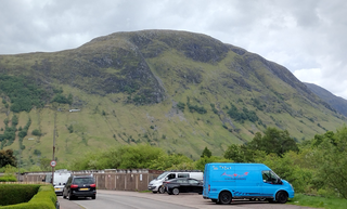
Glen Coe is a glen of volcanic origins, in the Highlands of Scotland. It lies in the north of the county of Argyll, close to the border with the historic province of Lochaber, within the modern council area of Highland. Glen Coe is regarded as the home of Scottish mountaineering and is popular with hillwalkers and climbers.

Henry W. Coe State Park is a state park of California, United States, preserving a vast tract of the Diablo Range. The park is located closest to the city of Morgan Hill, and is located in both Santa Clara and Stanislaus counties. The park contains over 87,000 acres (35,000 ha), making it the largest state park in northern California, and the second-largest in the state. Managed within its boundaries is a designated wilderness area of about 22,000 acres (8,900 ha). This is officially known as the Henry W. Coe State Wilderness, but locally as the Orestimba Wilderness. The 89,164-acre (36,083 ha) park was established in 1959.

Bidean nam Bian is the highest peak in a group of mountains south of Glen Coe and north of Glen Etive in the Scottish Highlands. With a height of 1,150 metres (3,770 ft), it is a Munro and the highest point in Argyll. It is a complex mountain, with many ridges and subsidiary peaks, one of which, Stob Coire Sgreamhach, is classified as a separate Munro.

Meall a' Bhùiridh (IPA:[ˈmauɫ̪ˈaˈvuːɾʲɪʝ]) is a mountain on the edge of Rannoch Moor in the Highlands of Scotland. It lies near the top of Glen Coe and Glen Etive, overlooking the Kings House Hotel inn and the A82 road. The Glencoe Ski area is located on the northern slopes of the peak.
Coe Hill is a mountain located in the Catskill Mountains of New York northeast of North Franklin. Jackson Hill is located southwest and White Hill is located southwest of Coe Hill.
South Brother is a mountain located in Piscataquis County, Maine, in Baxter State Park. South Brother is flanked to the southwest by Mount Coe, and to the northeast by North Brother; collectively the two are called "The Brothers".

Mount Coe is a mountain located in Piscataquis County, Maine, within Baxter State Park, about 5.5 mi (9 km) northwest of Mount Katahdin. Mt. Coe is flanked to the northeast by South Brother, and to the southwest by Mount O-J-I. The Mount Coe trail starts at Slide Dam on Newsowdnehunk Stream east bank at around 1,190 ft (360 m). The trail goes up to the east for about 1.2 mi (1.9 km) and then goes right (south) along the drainage from the Mt. Coe slide bending to the east and then northeast. The last 0.5 mi (0.80 km) is up the slide featured on the left margin of the photo where the trail gains around 800 ft (240 m).

Nippletop is a mountain located in Essex County, New York. The mountain is part of the Colvin Range. Nippletop is flanked to the northeast by Dial Mountain. To the east, it faces Dix Mountain across Hunters Pass, and to the west it faces Mount Colvin across Elk Pass.

Vly Mountain is a mountain located in the town of Halcott, New York, United States in Greene County. The mountain is part of the Catskill Mountains. Vly Mountain is flanked to the northwest by Bearpen Mountain, to the east by Vinegar Hill, to the northeast by Kipp Hill, and to the southeast by Beech Ridge.
The Little Rincon Mountains are a small range of mountains, lying to the east of the Rincon Mountains, at Tucson, of eastern Pima County, Arizona. The range is located in northwest Cochise County and is part of the western border of the San Pedro River and Valley, the major valley and river of western Cochise County. The river is northward flowing to meet the Gila River; its headwaters are south of the US-Mexico border in northern Sonora. A small part of the Little Rincon range's southwest lies in Pima County.
The Black Hills of Greenlee County are a 20 mi (32 km) long mountain range of the extreme northeast Sonoran Desert bordering the south of the White Mountains of eastern Arizona's transition zone.
The 5,080-acre (20.6 km2) Coyote Mountains Wilderness of Arizona is part of the Coyote Mountains of southern Arizona in the center of Pima County. The wilderness lies about 40 mi southwest of Tucson, in the northwest of the Altar Valley. Kitt Peak is 4 mi WSW.
Pigeon Hill is a small mountain chain located in Central New York region of New York located northeast of Burlington, New York. It is made by four main peaks with the highest being 2057 feet.
Jackson Hill is a mountain located in the Catskill Mountains of New York southwest of North Franklin. The peak of Jackson Hill is called Waterman Peak. Oak Hill is located southwest, Chamberlain Hill is located west-northwest, and Coe Hill is located northeast of Jackson Hill.
Red Hill is a mountain located in the Catskill Mountains of New York east-south of Frost Valley. Woodhull Mountain is located northeast of Red Hill.
Gallis Hill is a 794-foot-tall (242 m) mountain in the Catskill Mountains region of New York. It is located northwest of Kingston in Ulster County. Jockey Hill is located north-northeast, and Morgan Hill is located west of Gallis Hill. In 1927, the Conservation Department built a steel fire lookout tower on the mountain. In 1950, the tower was closed and disassembled then moved to Overlook Mountain, where it still remains today.
The Meall an t-Suidhe is a mountain in Scotland, located close to the Ben Nevis.

