Wilmington, Illinois

Last updated

Wilmington, Illinois
Wilmington IL.jpg
Baltimore Street (IL-53)
Nickname: 
The Island City
Will County Illinois Incorporated and Unincorporated areas Wilmington Highlighted.svg
Location of Wilmington in Will County, Illinois.
Country United States
State Illinois
Counties Will
Founded1836
Incorporated1854
Government
   Mayor Ben Dietz [1]
Area
[2]
  Total14.52 sq mi (37.61 km2)
  Land13.80 sq mi (35.75 km2)
  Water0.72 sq mi (1.86 km2)
Elevation
[3]
528 ft (161 m)
Population
 (2020)
  Total5,664
  Density410.35/sq mi (158.44/km2)
Time zone UTC-6 (CST)
  Summer (DST) UTC-5 (CDT)
ZIP code
60481
Area code 815
FIPS code 17-82101 [4]
GNIS feature ID2397328 [3]
Website www.wilmington-il.com

Wilmington is a city in Will County, Illinois, United States. Located on IL-53 and Historic Route 66 along the east bank of the Kankakee River, it is approximately 60 miles south-west from downtown Chicago (the Chicago Loop). The population was 5,724 at the 2010 census. Wilmington is just south of Midewin National Tallgrass Prairie, which is home the largest bison herd in the state. [5]

Contents

History

Thomas Cox purchased land near Alden's Island in 1834 and built a sawmill, corn cracker, gristmill, and a carding machine facility all of which were powered by water wheels situated on a mill right off of the Kankakee River which runs through Wilmington. [6]

The Gemini Giant at its former location in Wilmington on U.S. Route 66 Gemini-Giant.jpg
The Gemini Giant at its former location in Wilmington on U.S. Route 66

The city is home to the historic Eagle Hotel located on the northwest corner of state Rt 53 (Rt 66) and Water street (Rt 102). It later became famous as a stop on U.S. Route 66, which followed the route of modern-day Illinois Route 53. A notable attraction for travelers along this route is the Gemini Giant muffler man type statue. Countless photos of travelers, both domestic and foreign, standing at the base of the Gemini Giant are taken each year. [7]

Wilmington is also home to Cinder Ridge Golf Course, located off of I-55. Wilmington was the scene of the brutal murder of Riley Fox.

A mural depicting historic Downtown Wilmington was installed facing the Eagle Hotel in October 2023, in anticipation of the 100th anniversary of the establishment of Route 66 coming up in 2026. [8]

Geography

Wilmington is located at 41°18′27″N88°08′46″W / 41.307515°N 88.146143°W / 41.307515; -88.146143 . [9] It is located on the banks of the Kankakee River, approximately 50 miles (80 km) southwest of Chicago and 15 miles (24 km) south of Joliet.

One of Wilmington's most notable geographical features is a large island in the Kankakee River, much of which is occupied by a city park. This island divides the river into a large channel and a smaller one which was used as a natural mill race during the early years of the city. The island is the source of the city's nickname, "The Island City." [6]

According to the United States Census Bureau, the city has a total area of 4.5 square miles (12 km2), of which 4.2 square miles (11 km2) is land and 0.3 square miles (0.78 km2) (6.86%) is water.

Demographics

Historical population
CensusPop.Note
1870 1,828
1880 1,8722.4%
1890 1,576−15.8%
1900 1,420−9.9%
1910 1,4502.1%
1920 1,384−4.6%
1930 1,74125.8%
1940 1,92110.3%
1950 3,35474.6%
1960 4,21025.5%
1970 4,3353.0%
1980 4,4242.1%
1990 4,7437.2%
2000 5,1348.2%
2010 5,72411.5%
2020 5,664−1.0%
U.S. Decennial Census [10]

As of the census [11] of 2000, there were 5,134 people, 1,991 households, and 1,318 families residing in the city. The population density was 1,218.3 inhabitants per square mile (470.4/km2). There were 2,097 housing units at an average density of 497.6 per square mile (192.1/km2). The racial makeup of the city was 97.14% White, 0.74% African American, 0.35% Native American, 0.29% Asian, 0.02% Pacific Islander, 0.60% from other races, and 0.86% from two or more races. Hispanic or Latino of any race were 1.95% of the population.

There were 1,991 households, out of which 34.9% had children under the age of 18 living with them, 52.1% were married couples living together, 9.8% had a female householder with no husband present, and 33.8% were non-families. 28.4% of all households were made up of individuals, and 10.3% had someone living alone who was 65 years of age or older. The average household size was 2.51 and the average family size was 3.10.

In the city, the population was spread out, with 26.3% under the age of 18, 8.3% from 18 to 24, 29.4% from 25 to 44, 22.9% from 45 to 64, and 13.1% who were 65 years of age or older. The median age was 36 years. For every 100 females, there were 93.3 males. For every 100 females age 18 and over, there were 92.7 males.

The median income for a household in the city was $45,659, and the median income for a family was $53,648. Males had a median income of $41,966 versus $25,625 for females. The per capita income for the city was $24,357. About 5.1% of families and 5.2% of the population were below the poverty line, including 5.3% of those under age 18 and 9.3% of those age 65 or over.

Notable people

Related Research Articles

<span class="mw-page-title-main">Will County, Illinois</span> County in Illinois, United States

Will County is a county in the northeastern part of the state of Illinois. According to the 2020 census, it had a population of 696,355, an increase of 2.8% from 677,560 in 2010, making it Illinois's fourth-most populous county. The county seat is Joliet. Will County is one of the five collar counties of the Chicago–Naperville–Elgin, IL–IN–WI Metropolitan Statistical Area. The portion of Will County around Joliet uses area codes 815 and 779, while 630 and 331 are for far northern Will County and 708 is for central and eastern Will County.

<span class="mw-page-title-main">Kankakee County, Illinois</span> County in Illinois, United States

Kankakee County is a county located in the U.S. state of Illinois. According to the 2020 census, it has a population of 107,502. Its county seat is Kankakee. Kankakee County comprises the Kankakee, IL Metropolitan Statistical Area.

<span class="mw-page-title-main">Iroquois County, Illinois</span> County in Illinois, United States

Iroquois County is a county located in the northeast part of the U.S. state of Illinois. According to the 2020 United States Census, it has a population of 27,077. It is the only county in the United States to be named Iroquois, after the American Indian people. The county seat is Watseka. The county is located along the border with Indiana.

<span class="mw-page-title-main">Chebanse, Illinois</span> Village in Illinois, United States

Chebanse is a village in Iroquois and Kankakee counties in the U.S. state of Illinois. The population was 1,044 at the 2020 census. The Kankakee County portion of Chebanse is included in the Kankakee-Bradley, Illinois Metropolitan Statistical Area.

<span class="mw-page-title-main">Aroma Park, Illinois</span> Village in Illinois, United States

Aroma Park is a village in Kankakee County, Illinois, United States, along the Kankakee River opposite the mouth of the Iroquois River. Aroma Park is a suburb of the city of Kankakee. Aroma Park's population was 743 at the 2010 census, down from 821 at the 2000 census. It is included in the Kankakee-Bradley, Illinois Metropolitan Statistical Area.

<span class="mw-page-title-main">Bradley, Illinois</span> Village in Illinois, United States

Bradley is a village in Kankakee County, Illinois, United States. It is a suburb of the city of Kankakee. The population was 15,895 at the 2010 census, up from 12,784 at the 2000 census.

<span class="mw-page-title-main">Buckingham, Illinois</span> Village in Illinois, United States

Buckingham is a village in Kankakee County, Illinois, United States. The population was 300 at the 2010 census, up from 237 at the 2000 census. The village is about 63.7 miles south west of Chicago Illinois. It is included in the Kankakee-Bradley, Illinois Metropolitan Statistical Area.

<span class="mw-page-title-main">Essex, Illinois</span> Village in Illinois, United States

Essex is a village in Kankakee County, Illinois, United States. The population was 802 at the 2010 census, up from 554 at the 2000 census. It is included in the Kankakee-Bradley, Illinois Metropolitan Statistical Area.

<span class="mw-page-title-main">Herscher, Illinois</span> Village in Illinois, United States

Herscher is a village in Kankakee County, Illinois, United States. The population was 1,521 at the 2020 census. It is part of the Kankakee–Bradley metropolitan area.

<span class="mw-page-title-main">Kankakee, Illinois</span> City in Illinois, United States

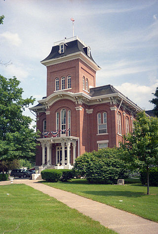
Kankakee is a city in and the county seat of Kankakee County, Illinois, United States. Located on the Kankakee River, as of 2020, the city's population was 24,052. Kankakee is a principal city of the Kankakee-Bourbonnais-Bradley Metropolitan Statistical Area. It serves as an anchor city in the rural plains outside Chicago.

<span class="mw-page-title-main">Manteno, Illinois</span> Village in Illinois, United States

Manteno is a village in Kankakee County, Illinois, United States. The population was 9,210 at the 2020 census. It is part of the Kankakee-Bourbonnais-Bradley Metropolitan Statistical Area.

<span class="mw-page-title-main">Sun River Terrace, Illinois</span> Village in Illinois, United States

Sun River Terrace is a village in Kankakee County, Illinois, United States. The population was 455 at the 2020 census. It is included in the Kankakee-Bradley, Illinois Metropolitan Statistical Area.

<span class="mw-page-title-main">Union Hill, Illinois</span> Village in Illinois, United States

Union Hill is a village in Kankakee County, Illinois, United States. The population was 58 at the 2010 census. It is included in the Kankakee-Bradley, Illinois Metropolitan Statistical Area.

<span class="mw-page-title-main">Troy Grove, Illinois</span> Village in Illinois, United States

Troy Grove is a village in LaSalle County, Illinois, United States. The population was 225 at the 2020 census, down from 250 at the 2010 census. It is part of the Ottawa, IL Micropolitan Statistical Area.

<span class="mw-page-title-main">Godfrey, Illinois</span> Village in Illinois, United States

Godfrey is a village in Madison County, Illinois, United States. The population was 17,825 at the 2020 census. Godfrey is located within the River Bend portion of the Greater St. Louis metropolitan area.

<span class="mw-page-title-main">Litchfield, Illinois</span> City in Illinois, United States

Litchfield is a city in Montgomery County, Illinois, United States. The population was 6,605 at the 2020 census. It is located in South Central Illinois, south of Springfield, the state capital.

<span class="mw-page-title-main">South Jacksonville, Illinois</span> Village in Illinois, United States

South Jacksonville is a village in Morgan County, Illinois, United States. The population was 3,302 at the 2020 census. It is part of the Jacksonville Micropolitan Statistical Area.

<span class="mw-page-title-main">Elwood, Illinois</span> Village in Illinois, United States

Elwood is a village in rural Will County, Illinois, United States, approximately 40 miles southwest of Chicago. The population was 2,229 at the 2020 United States Census, down from 2,279 in 2010.

<span class="mw-page-title-main">Prairie Township, Edgar County, Illinois</span> Township in Illinois, United States

Prairie Township is one of fifteen townships in Edgar County, Illinois, USA. As of the 2020 census, its population was 222 and it contained 107 housing units.

<span class="mw-page-title-main">Joliet Army Ammunition Plant</span> United States Army arsenal in Illinois

Joliet Army Ammunition Plant (JOAAP, formerly known as the Joliet Arsenal) was a United States Army arsenal located in Will County, Illinois, near Elwood, Illinois, south of Joliet, Illinois. Opened in 1940 during World War II, the facility consisted of the Elwood Ordnance Plant (EOP) and the Kankakee Ordnance Works (KNK). In 1945, the two were deactivated and combined forming the Joliet Arsenal. The plant was reactivated for the Korean War and renamed Joliet Army Ammunition Plant during the Vietnam War. Production of TNT ended in 1976, and the major plant operations closed shortly after in the late 1970s. The facility briefly revived an automated load-assemble-pack (LAP) artillery shell operation that was managed by the Honeywell Corporation during the Reagan administration in the 1980s before it was finally closed.

References

  1. "City Officials". City of Wilmington. Retrieved June 23, 2021.
  2. "2020 U.S. Gazetteer Files". United States Census Bureau. Retrieved March 15, 2022.
  3. 1 2 U.S. Geological Survey Geographic Names Information System: Wilmington, Illinois
  4. "Wilmington, Illinois (Will County)". Roadside Thoughts. Retrieved June 14, 2017.
  5. Wetli, Patty (May 7, 2021). "It's a Bison Baby Boom at Midewin National Tallgrass Prairie". WTTW News.
  6. 1 2 "Wilmington History". Wilmington Public Library. Archived from the original on November 12, 2023.
  7. Searl, Ryan (March 11, 2021). "Legendary Route 66 Sights: The Gemini Giant". The First Hundred Miles. Archived from the original on May 18, 2021.
  8. "Have you seen the new mural?". the DAILY 411. October 12, 2023.
  9. "US Gazetteer files: 2010, 2000, and 1990". United States Census Bureau. February 12, 2011. Retrieved April 23, 2011.
  10. "Census of Population and Housing". Census.gov. Retrieved June 4, 2015.
  11. "U.S. Census website". United States Census Bureau . Retrieved January 31, 2008.