Pudong is a district of Shanghai located east of the Huangpu, the river which flows through central Shanghai. The name Pudong was originally applied to the Huangpu's east bank, directly across from the west bank or Puxi, the historic city center. It now refers to the broader Pudong New Area, a state-level new area which extends all the way to the East China Sea.
Huangpu District, makes up the eastern part of Shanghai's traditional urban core and is today the most central of Shanghai's 16 districts. Huangpu district is the seat of municipal government, includes key attractions such as The Bund and the Old City God Temple, as well as popular shopping districts such as Nanjing Road, Huaihai Road, and Xintiandi. The Huangpu District is one of the most densely populated urban districts in the world.
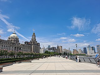
The Bund is a waterfront area and a protected historical district in central Shanghai. The area centers on a section of Zhongshan Road within the former Shanghai International Settlement, which runs along the western bank of the Huangpu River in the eastern part of Huangpu. The area along the river faces the modern skyscrapers of Lujiazui in Pudong. The Bund usually refers to the buildings and wharves on this section of the road, as well as some adjacent areas. This region has a significant European influence, with the style of many structures most comparable to that of European cities, particularly Gothic, Baroque, Neoclassical, Romanesque, Art Deco, and Renaissance architecture. Additionally, some of the city's top eateries are located there. From the 1860s to the 1930s, it was the rich and powerful center of the foreign establishment in Shanghai, operating as a legally protected treaty port.
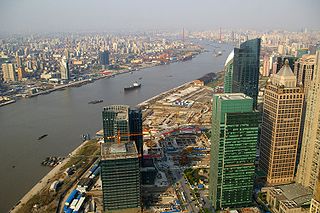
The Huangpu, formerly romanized as Whangpoo, is a 113 km-long (70 mi) river flowing north through Shanghai. The Bund and Lujiazui are located along the Huangpu River.

Puxi is the historic center of Shanghai, China, and remains the home of approximately 48% of Shanghai's residents in an area of 288 km2. Puxi is distinguished from Pudong to its east, which is separated from it by the Huangpu River. Despite the growing importance of Pudong's Lujiazui area, Puxi remains Shanghai's cultural, residential and commercial center.

Line 2 is an east–west line in the Shanghai Metro network. With a length of nearly 64 km (40 mi), it is the second longest line in the metro system after line 11. Line 2 runs from National Exhibition and Convention Center in the west to Pudong Airport Terminal 1&2 in the east, passing Hongqiao Airport, the Huangpu river, and the Lujiazui Financial District in Pudong. With a daily ridership of over 1.9 million, it is the busiest line on the Shanghai Metro. The eastern portion of the line, Guanglan Road - Pudong International Airport section, was operated as an independent service route until April 19, 2019, when through service began. The line is colored light green on system maps.

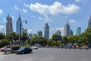
Lujiazui is a locality in Shanghai, a peninsula formed by a bend in the Huangpu River. Since the early 1990s, Lujiazui has been developed specifically as a new financial district of Shanghai. The decision to earmark Lujiazui for this purpose reflects its location: it is located on the east side of the Huangpu River in Pudong, and sits directly across the river from the old financial and business district of the Bund.

East Xujing is a station on Line 2 of the Shanghai Metro. It opened on 16 March 2010, and is the current western terminus of the line. Buses from East Xujing Station will take passengers to other locations in Qingpu.
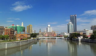
Suzhou Creek, also called the Wusong (Woosung) River, is a river that passes through the Shanghai city center. It is named after the neighboring city of Suzhou (Soochow), Jiangsu, the predominant settlement in this area prior to the rise of Shanghai as a metropolis.

The Shanghai French Concession was a foreign concession in Shanghai, China from 1849 until 1943, which progressively expanded in the late 19th and early 20th centuries. The concession came to an end in 1943, when Vichy France under German pressure signed it over to the pro-Japanese Reorganized National Government of China in Nanjing. For much of the 20th century, the area covered by the former French Concession remained the premier residential and retail district of Shanghai, and was also one of the centers of Catholicism in China. Despite re-development over the last few decades, the area retains a distinct character and is a popular tourist destination.
The urban planning of Shanghai refers to various phases of planning and development of Shanghai, presently the largest city in China and one of the largest in the world. The topic is the focus of the city's Urban Planning Museum, located in People's Square beside City Hall.

Yan'an Elevated Road is an elevated expressway in the city of Shanghai, China. It runs along Yan'an Road in its entirety, continuing from the east terminus of G50 Shanghai-Chongqing Expressway at Huqingping Interchange to just beyond the old building of Shanghai Natural History Museum, at which point it ends and rejoins Yan'an Road on the surface. Traffic is then partly directed underground to the Bund Tunnel. Motorists continuing east can cross the Huangpu River using the East Yan'an Road Tunnel to Pudong.
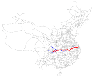
The Shanghai–Chongqing Expressway, designated as G50 and commonly referred to as the Huyu Expressway is an east-west bound expressway that connects the cities of Shanghai, China in Yangtze River Delta, and Chongqing in western China. The expressway runs through six provinces/municipalities and adjoin major cities such as Wuhu, Anqing, Wuhan and Yichang, roughly parallel to G42 Shanghai-Chengdu Expressway to its south. The thoroughfare begins at Huqingping Outer Ring Interchange near Hongqiao International Airport, where it meets S20 Outer Ring Expressway in Shanghai, and terminates at an interchange in Jiangbei District, where the highway joins G75 Lanzhou-Haikou Expressway. It is fully complete and spans 1,900 km (1,200 mi) in length.

Saint Joseph's Church at Yang-king-pang is a church in the Yangjingbang area of Huangpu District, Shanghai. It is colloquially known as the Yang-king-pang or Yangjingbang Catholic Church (洋泾浜天主堂).

Huaihai Road or Huaihai Lu is a road in Shanghai, China. The central section of Huaihai Road is one of the two major shopping streets in central Shanghai; the other is Nanjing Road. Compared with the more touristy Nanjing Road, Huaihai Road is more upscale, and is the preferred destination of local residents. Huaihai Road comprises three sections, the main section being Middle Huaihai Road in the former French Concession of Shanghai. Middle Huaihai Road is also well known by its former French name Avenue Joffre. Huaihai Road East was in the original French Concession and was formerly known as Rue Ningpo (寧波路), while Huaihai Road West was an extra-settlement road built by the Shanghai International Settlement and formerly known as Jordan Road (喬敦路)
The Bund Tunnel is a 3.3 km (2.1 mi) sub-surface road and road tunnel in the city of Shanghai, China. The tunnel connects the districts of Hongkou to the north and Huangpu to the south.

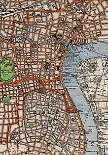
The British Concession or Settlement was a foreign enclave in Shanghai within the Qing Empire which existed from around 1845 until its unification with the American area, located directly north of it across Suzhou Creek to form the Shanghai International Settlement in 1863.
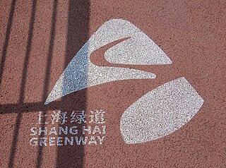
The Shanghai Greenway is a greenway in Shanghai, China. It consists of many sections of marked paths lined with landscaped foliage passing through several urban parks.