Sawyer, North Dakota

Last updated

Sawyer, North Dakota
ND Ward County Sawyer.svg
Location of Sawyer, North Dakota
Coordinates: 48°05′22″N101°03′12″W / 48.08944°N 101.05333°W / 48.08944; -101.05333
CountryUnited States
State North Dakota
County Ward
Founded1898
Area
[1]
  Total0.49 sq mi (1.27 km2)
  Land0.49 sq mi (1.27 km2)
  Water0.00 sq mi (0.00 km2)
Elevation
[2]
1,536 ft (468 m)
Population
 (2020) [3]
  Total319
  Estimate 
(2022) [4]
312
  Density649.69/sq mi (250.90/km2)
Time zone UTC-6 (Central (CST))
  Summer (DST) UTC-5 (CDT)
ZIP code
58781
Area code 701
FIPS code 38-70980
GNIS feature ID1036255 [2]

Sawyer is a city in Ward County, North Dakota, United States. The population was 319 at the 2020 census. [3] It is part of the Minot Micropolitan Statistical Area. Sawyer was founded in 1898.

Contents

Geography

According to the United States Census Bureau, the city has a total area of 0.48 square miles (1.24 km2), all land. [5]

Demographics

Historical population
CensusPop.Note
1910 327
1920 241−26.3%
1930 206−14.5%
1940 27131.6%
1950 264−2.6%
1960 39047.7%
1970 373−4.4%
1980 41711.8%
1990 319−23.5%
2000 37718.2%
2010 357−5.3%
2020 319−10.6%
2022 (est.)312 [4] −2.2%
U.S. Decennial Census [6]
2020 Census [3]

2010 census

As of the census of 2010, there were 357 people, 139 households, and 99 families residing in the city. The population density was 743.8 inhabitants per square mile (287.2/km2). There were 150 housing units at an average density of 312.5 per square mile (120.7/km2). The racial makeup of the city was 96.6% White, 0.3% African American, 1.1% Native American, 0.3% Asian, 0.3% from other races, and 1.4% from two or more races. Hispanic or Latino of any race were 0.8% of the population.

There were 139 households, of which 35.3% had children under the age of 18 living with them, 58.3% were married couples living together, 8.6% had a female householder with no husband present, 4.3% had a male householder with no wife present, and 28.8% were non-families. 24.5% of all households were made up of individuals, and 10.8% had someone living alone who was 65 years of age or older. The average household size was 2.57 and the average family size was 3.05.

The median age in the city was 38.4 years. 28% of residents were under the age of 18; 7.1% were between the ages of 18 and 24; 25.5% were from 25 to 44; 27.8% were from 45 to 64; and 11.8% were 65 years of age or older. The gender makeup of the city was 52.4% male and 47.6% female.

2000 census

As of the census of 2000, there were 377 people, 150 households, and 108 families residing in the city. The population density was 782.4 inhabitants per square mile (302.1/km2). There were 162 housing units at an average density of 336.2 per square mile (129.8/km2). The racial makeup of the city was 98.14% White, 0.53% Native American, 1.06% Asian, 0.27% from other races. Hispanic or Latino of any race were 1.06% of the population.

There were 150 households, out of which 35.3% had children under the age of 18 living with them, 60.0% were married couples living together, 8.7% had a female householder with no husband present, and 28.0% were non-families. 24.7% of all households were made up of individuals, and 10.0% had someone living alone who was 65 years of age or older. The average household size was 2.51 and the average family size was 2.98.

In the city, the population was spread out, with 29.4% under the age of 18, 5.8% from 18 to 24, 30.8% from 25 to 44, 22.3% from 45 to 64, and 11.7% who were 65 years of age or older. The median age was 36 years. For every 100 females, there were 107.1 males. For every 100 females age 18 and over, there were 107.8 males.

The median income for a household in the city was $30,750, and the median income for a family was $35,000. Males had a median income of $30,417 versus $14,750 for females. The per capita income for the city was $13,245. About 6.9% of families and 8.0% of the population were below the poverty line, including 6.7% of those under age 18 and none of those age 65 or over.

Related Research Articles

<span class="mw-page-title-main">Dixon, Iowa</span> City in Iowa, United States

Dixon is a city in Scott County, Iowa, United States. The population was 202 at the time of the 2020 census.

<span class="mw-page-title-main">Sawyer, Kansas</span> City in Pratt County, Kansas

Sawyer is a city in Pratt County, Kansas, United States. As of the 2020 census, the population of the city was 89.

<span class="mw-page-title-main">Hickory Hill, Kentucky</span> City in Kentucky, United States

Hickory Hill is a home rule-class city in Jefferson County, Kentucky, United States. The population was 114 at the 2010 census.

<span class="mw-page-title-main">Lake Shore, Minnesota</span> City in Minnesota, United States

Lake Shore is a city in Cass County, Minnesota, United States. The population was 1,056 at the 2020 census. It is part of the Brainerd Micropolitan Statistical Area.

<span class="mw-page-title-main">Warba, Minnesota</span> City in Minnesota, United States

Warba is a city in Itasca County, Minnesota, United States. The population was 181 at the 2010 census.

<span class="mw-page-title-main">Sunburg, Minnesota</span> City in Minnesota, United States

Sunburg is a city in Kandiyohi County, Minnesota, United States. The population was 100 at the 2010 census.

<span class="mw-page-title-main">Harding, Minnesota</span> City in Minnesota, United States

Harding is a city in Morrison County, Minnesota, United States, along the Platte River. The population was 123 at the 2020 census.

<span class="mw-page-title-main">Bluffton, Minnesota</span> City in Minnesota, United States

Bluffton is a city in Otter Tail County, Minnesota, United States, along the Leaf River. The population was 210 at the 2020 census.

<span class="mw-page-title-main">Erhard, Minnesota</span> City in Minnesota, United States

Erhard is a city in Otter Tail County, Minnesota, United States. The population was 132 at the 2020 census.

<span class="mw-page-title-main">Goodview, Minnesota</span> City in Minnesota, United States

Goodview is a city in Winona County, Minnesota, United States. The population was 4,158 at the 2020 census.

<span class="mw-page-title-main">Lupus, Missouri</span> City in Missouri, United States

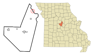
Lupus is a city in Moniteau County, Missouri, United States. The population was 33 at the 2010 census. It is part of the Jefferson City, Missouri Metropolitan Statistical Area.

<span class="mw-page-title-main">Clarkson Valley, Missouri</span> City in Missouri, United States

Clarkson Valley is a city in St. Louis County, Missouri, United States. The population was 2,609 at the 2020 census.

<span class="mw-page-title-main">Sawyer, Oklahoma</span> Town in Oklahoma, United States

Sawyer is a town in Choctaw County, Oklahoma, United States. The population was 321 at the 2010 census.

<span class="mw-page-title-main">War, West Virginia</span> City in West Virginia, United States

War is a city in McDowell County, West Virginia, United States. The population was 690 at the 2020 census. War was incorporated in 1920 by the Circuit Court of McDowell County. Its name is derived from War Creek, whose confluence with Dry Fork is located within the city. War is the only place in the United States with this name. War was formerly known as Miner's City. It is also known for being a setting in the movie October Sky; as writer Homer Hickam's Big Creek High School.

<span class="mw-page-title-main">Bass Lake, Sawyer County, Wisconsin</span> Town in Wisconsin, United States

Bass Lake is a town in Sawyer County, Wisconsin, United States. The population was 2,244 at the 2000 census. The census-designated place of Little Round Lake is located in the town. The unincorporated community of Northwoods Beach is also located in the town.

<span class="mw-page-title-main">Edgewater, Wisconsin</span> Town in Wisconsin, United States

Edgewater is a town in Sawyer County, Wisconsin, United States. The population was 586 at the 2000 census. The unincorporated communities of Edgewater and Wooddale are located in the town. The unincorporated community of Yarnell is also located partially in the town.

<span class="mw-page-title-main">Minneiska, Minnesota</span> City in Minnesota, United States

Minneiska is a city in Wabasha and Winona counties in the U.S. state of Minnesota. The population was 111 at the 2010 census.

<span class="mw-page-title-main">Hayward (town), Wisconsin</span> Town in Wisconsin, United States

Hayward is a town in Sawyer County, Wisconsin, United States. The population was 3,279 at the 2000 census. The town is located near the City of Hayward. The census-designated place of Chief Lake is located in the town.

<span class="mw-page-title-main">Radisson, Wisconsin</span> Village in Wisconsin, United States

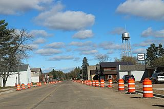
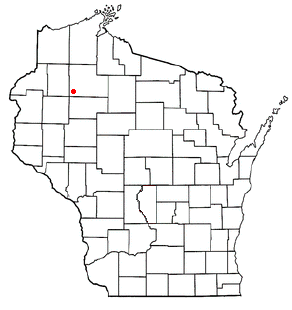
Radisson is a village in Sawyer County, Wisconsin, United States, along the Couderay River. The population was 241 at the 2010 census. The village is located within the Town of Radisson and was named in honor of the early French explorer, Pierre-Esprit Radisson (c.1636–1710).

<span class="mw-page-title-main">Winter, Wisconsin</span> Village in Wisconsin, United States

Winter is a village in Sawyer County, Wisconsin, United States. The population was 233 at the 2010 census. The village is within the Town of Winter.

References

  1. "ArcGIS REST Services Directory". United States Census Bureau. Retrieved September 20, 2022.
  2. 1 2 U.S. Geological Survey Geographic Names Information System: Sawyer, North Dakota
  3. 1 2 3 "Explore Census Data". United States Census Bureau . Retrieved November 12, 2023.
  4. 1 2 "City and Town Population Totals: 2020-2022". United States Census Bureau. November 12, 2023. Retrieved November 12, 2023.
  5. "US Gazetteer files 2010". United States Census Bureau. Archived from the original on January 12, 2012. Retrieved June 14, 2012.
  6. United States Census Bureau. "Census of Population and Housing" . Retrieved October 23, 2013.