Surrey, North Dakota

Last updated

Surrey, North Dakota
ND Ward County Surrey.svg
Location of Surrey, North Dakota
Coordinates: 48°14′36″N101°07′59″W / 48.24333°N 101.13306°W / 48.24333; -101.13306
CountryUnited States
State North Dakota
County Ward
FoundedJune 18, 1900
Incorporated 1951
Government
   Mayor Michael Thiesen
Area
[1]
  Total2.12 sq mi (5.49 km2)
  Land2.11 sq mi (5.47 km2)
  Water0.01 sq mi (0.02 km2)
Elevation
[2]
1,614 ft (492 m)
Population
 (2020) [3]
  Total1,357
  Estimate 
(2022) [4]
1,393
  Density642.52/sq mi (248.04/km2)
Time zone UTC-6 (Central (CST))
  Summer (DST) UTC-5 (CDT)
ZIP code
58785
Area code 701
FIPS code 38-77180
GNIS feature ID1036290 [2]
Website surreynd.org

Surrey is a town in Ward County, North Dakota, United States. The population was 1,357 at the 2020 census. [3] Official incorporation of Surrey occurred in 1951. The city is part of the Minot Micropolitan Statistical Area.

Contents

History

Surrey was founded on June 18, 1900, and named after Surrey, England, by Great Northern Railway officials. It was one of several sites along the Great Northern's transcontinental route between Devils Lake and Minot that were named after places in England (the others were Berwick, Leeds, Norwich, Penn, Rugby, Tunbridge, and York).

Geography

According to the United States Census Bureau, the city has a total area of 0.99 square miles (2.56 km2), of which 0.98 square miles (2.54 km2) is land and 0.01 square miles (0.03 km2) is water. [5]

Demographics

Historical population
CensusPop.Note
1960 309
1970 36116.8%
1980 999176.7%
1990 856−14.3%
2000 9177.1%
2010 9341.9%
2020 1,35745.3%
2022 (est.)1,393 [4] 2.7%
U.S. Decennial Census [6]
2020 Census [3]

2010 census

As of the census of 2010, there were 934 people, 334 households, and 264 families residing in the city. The population density was 953.1 inhabitants per square mile (368.0/km2). There were 335 housing units at an average density of 341.8 per square mile (132.0/km2). The racial makeup of the city was 95.3% White, 0.6% African American, 1.3% Native American, 0.3% Asian, 0.2% Pacific Islander, 0.2% from other races, and 2.0% from two or more races. Hispanic or Latino of any race were 1.4% of the population.

There were 334 households, of which 39.2% had children under the age of 18 living with them, 65.6% were married couples living together, 7.8% had a female householder with no husband present, 5.7% had a male householder with no wife present, and 21.0% were non-families. 16.2% of all households were made up of individuals, and 3.3% had someone living alone who was 65 years of age or older. The average household size was 2.80 and the average family size was 3.09.

The median age in the city was 32.5 years. 28.2% of residents were under the age of 18; 8.2% were between the ages of 18 and 24; 29.9% were from 25 to 44; 25.8% were from 45 to 64; and 7.8% were 65 years of age or older. The gender makeup of the city was 51.2% male and 48.8% female.

2000 census

As of the census of 2000, there were 917 people, 307 households, and 260 families residing in the city. The population density was 943.1 inhabitants per square mile (364.1/km2). There were 313 housing units at an average density of 321.9 per square mile (124.3/km2). The racial makeup of the city was 97.27% White, 1.85% Native American, 0.33% Asian, and 0.55% from two or more races. Hispanic or Latino of any race were 0.87% of the population.

There were 307 households, out of which 53.4% had children under the age of 18 living with them, 66.4% were married couples living together, 13.0% had a female householder with no husband present, and 15.0% were non-families. 12.4% of all households were made up of individuals, and 2.6% had someone living alone who was 65 years of age or older. The average household size was 2.99 and the average family size was 3.24.

In the city, the population was spread out, with 34.5% under the age of 18, 6.8% from 18 to 24, 34.5% from 25 to 44, 19.3% from 45 to 64, and 5.0% who were 65 years of age or older. The median age was 32 years. For every 100 females, there were 102.4 males. For every 100 females age 18 and over, there were 99.7 males.

The median income for a household in the city was $43,403, and the median income for a family was $46,250. Males had a median income of $29,688 versus $19,375 for females. The per capita income for the city was $14,679. About 5.5% of families and 5.9% of the population were below the poverty line, including 8.6% of those under age 18 and 11.8% of those age 65 or over.

Transportation

Amtrak’s Empire Builder, which operates between Seattle/Portland and Chicago, passes through the town on BNSF tracks, but makes no stop. The nearest station is located in Minot, 8 miles (13 km) to the west.

Climate

This climatic region is typified by large seasonal temperature differences, with warm to hot (and often humid) summers and cold (sometimes severely cold) winters. According to the Köppen Climate Classification system, Surrey has a humid continental climate, abbreviated "Dfb" on climate maps. [7]

Related Research Articles

<span class="mw-page-title-main">Anamoose, North Dakota</span> City in North Dakota, United States

Anamoose is a city in McHenry County, North Dakota, United States. The population was 230 at the 2020 census. It is part of the Minot Micropolitan Statistical Area.

<span class="mw-page-title-main">York, North Dakota</span> City in North Dakota, United States

York is a small rural village in Benson County, North Dakota, United States. The population was 17 at the 2020 census. There is a gasoline station there, and a granary, and farm equipment repair services.

<span class="mw-page-title-main">Bowman, North Dakota</span> City in North Dakota, United States

Bowman is a city and county seat of Bowman County, North Dakota, United States. The population was 1,470 at the 2020 census.

<span class="mw-page-title-main">Balfour, North Dakota</span> City in North Dakota, United States

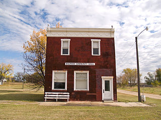
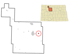
Balfour is a city in McHenry County, North Dakota, United States. The population was 20 at the 2020 census. It is part of the Minot Micropolitan Statistical Area.

<span class="mw-page-title-main">Bantry, North Dakota</span> City in North Dakota, United States

Bantry is a city in McHenry County, North Dakota, United States. The population was 6 at the 2020 census. It is part of the Minot Micropolitan Statistical Area. Bantry was founded in 1905. Bantry was founded by Irish settlers. The City of Bantry dissolved in November 2019 and the area reverted to Bantry township.

<span class="mw-page-title-main">Deering, North Dakota</span> City in North Dakota, United States

Deering is an unincorporated rural village in McHenry County, North Dakota, United States. In addition to homes, there are a church, a bar, a combined country store and restaurant, an auto body shop, an agricultural supplies outfit, and a set of free-standing gas pumps. The population was 94 at the 2020 census. It is part of the Minot Micropolitan Statistical Area. Deering was founded in 1903.

<span class="mw-page-title-main">Drake, North Dakota</span> City in North Dakota, United States

Drake is a city in McHenry County, North Dakota, United States. The population was 292 at the 2020 census. It is part of the Minot Micropolitan Statistical Area. Drake was founded in 1902 and named after Herman Drake, a settler.

<span class="mw-page-title-main">Upham, North Dakota</span> City in North Dakota, United States

Upham is a city in McHenry County, North Dakota, United States. The population was 135 at the 2020 census. It is part of the Minot Micropolitan Statistical Area. Upham was founded in 1905.

<span class="mw-page-title-main">Velva, North Dakota</span> City in North Dakota, United States

Velva is a city in McHenry County, North Dakota, United States. Part of the Minot Micropolitan Statistical Area, it was founded in 1897 and the population was 1,086 at the 2020 census. Southeast of Minot, Velva is at the southernmost point of the Souris River.

<span class="mw-page-title-main">Voltaire, North Dakota</span> City in North Dakota, United States

Voltaire is a city in McHenry County, North Dakota, United States. The population was 46 at the 2020 census. It is part of the Minot Micropolitan Statistical Area.

<span class="mw-page-title-main">Washburn, North Dakota</span> City in North Dakota, United States

Washburn is a city in southern McLean County, North Dakota, United States. Located along the upper Missouri River, it is the county seat of McLean County. The population was 1,300 at the 2020 census.

<span class="mw-page-title-main">Loraine, North Dakota</span> City in North Dakota, United States

Loraine is a city in Renville County, North Dakota, United States. The population was 9 at the 2020 census. It is part of the Minot Micropolitan Statistical Area.

<span class="mw-page-title-main">Tolley, North Dakota</span> City in North Dakota, United States

Tolley is a city in Renville County, North Dakota, United States. The population was 41 at the 2020 census. It is part of the Minot Micropolitan Statistical Area. Tolley was founded by Eli Crane Tolley in 1905.

<span class="mw-page-title-main">Berthold, North Dakota</span> City in North Dakota, United States

Berthold is a town in Ward County, North Dakota, United States. The population was 490 at the 2020 census.

<span class="mw-page-title-main">Des Lacs, North Dakota</span> City in North Dakota, United States

Des Lacs is a city in Ward County, North Dakota, United States. The population was 185 at the 2020 census. It is part of the Minot Micropolitan Statistical Area. Des Lacs was founded in 1888, named after the Riviere de Lacs, from the French for "River [of] The Lakes."

<span class="mw-page-title-main">Donnybrook, North Dakota</span> City in North Dakota, United States

Donnybrook is a city in Ward County, North Dakota, United States. The population was 75 at the 2020 census. It is part of the Minot Micropolitan Statistical Area.

<span class="mw-page-title-main">Douglas, North Dakota</span> City in North Dakota, United States

Douglas is a city in Ward County, North Dakota, United States. The population was 93 at the 2020 census. It is part of the Minot Micropolitan Statistical Area. Douglas was founded in 1906.

<span class="mw-page-title-main">Kenmare, North Dakota</span> City in North Dakota, United States

Kenmare is a city in Ward County, North Dakota, United States. The population was 961 at the 2020 census. Kenmare is part of the Minot Micropolitan Statistical Area.

<span class="mw-page-title-main">Makoti, North Dakota</span> City in North Dakota, United States

Makoti is a city in Ward County, North Dakota, United States. The population was 148 at the 2020 census. It is part of the Minot Micropolitan Statistical Area. Makoti was founded in 1911.

<span class="mw-page-title-main">Ryder, North Dakota</span> City in North Dakota, United States

Ryder is a city in Ward County, North Dakota, United States. The population was 108 at the 2020 census. It is part of the Minot Micropolitan Statistical Area. Ryder was founded in 1906.

References

  1. "ArcGIS REST Services Directory". United States Census Bureau. Retrieved September 20, 2022.
  2. 1 2 U.S. Geological Survey Geographic Names Information System: Surrey, North Dakota
  3. 1 2 3 "Explore Census Data". United States Census Bureau . Retrieved October 22, 2023.
  4. 1 2 "City and Town Population Totals: 2020-2022". United States Census Bureau. October 22, 2023. Retrieved October 22, 2023.
  5. "US Gazetteer files 2010". United States Census Bureau. Archived from the original on January 12, 2012. Retrieved June 14, 2012.
  6. United States Census Bureau. "Census of Population and Housing" . Retrieved October 23, 2013.
  7. Climate Summary for Surrey, North Dakota