Woodford County is a county located in the state of Illinois. The 2020 United States Census listed its population at 38,467. Its county seat is Eureka. Woodford County is part of the Peoria, IL, Metropolitan Statistical Area. Its name comes from General William Woodford, an officer of the American Revolutionary War who served at the brutal military encampment at Valley Forge, Pennsylvania.

Tazewell County is a county in the U.S. state of Illinois. According to the 2020 census, it had a population of 131,343. Its county seat and largest city is Pekin. It is pronounced with a short "a", to rhyme with "razz" rather than "raze."

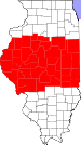
Peoria County is located in the U.S. state of Illinois. The 2020 United States Census listed its population at 181,830. Its county seat is Peoria. Peoria County is part of the Peoria, IL Metropolitan Statistical Area.

Marshall County is a county located in the U.S. state of Illinois. According to the 2020 census, it had a population of 11,742. Its county seat is Lacon.
Washburn is a village mostly in Woodford County, with a small northerly portion in Marshall County, Illinois, United States. The population was 1,032 at the 2020 census. It is part of the Peoria Metropolitan Statistical Area.

Pekin is a city in and the county seat of Tazewell County in the U.S. state of Illinois. Located on the Illinois River, Pekin is the largest city of Tazewell County and the second most populous municipality of the Peoria metropolitan area, after Peoria itself. As of the 2020 census, its population is 31,731. A small portion of the city limits extend into Peoria County. It is a suburb of Peoria and is part of the Peoria Metropolitan Statistical Area.

Peoria Heights is a village lying in Peoria County in the U.S. state of Illinois. The population was 6,156 at the 2010 census, down from 6,635 in 2000. Peoria Heights is a suburb of Peoria, is sometimes referred to as Uptown, and is surrounded by the city except for its eastern boundary on Peoria Lake, a relatively wider section of the Illinois River. It is part of the Peoria, Illinois Metropolitan Statistical Area.

Creve Coeur is a village in Groveland Township, Tazewell County, Illinois, United States. As of the 2020 census, the village population was 4,934. Creve Coeur is a suburb of Peoria and is part of the Peoria, Illinois Metropolitan Statistical Area.

Deer Creek is a village in Tazewell and Woodford counties in the U.S. state of Illinois. The population was 667 at the 2020 census. Deer Creek is part of the Peoria, Illinois Metropolitan Statistical Area.

Delavan is a city in Tazewell County, Illinois, United States. Its population was 1,689 in the 2010 census. It is a part of the Peoria, Illinois Metropolitan Statistical Area.

Hopedale is a village in Tazewell County, Illinois, United States. The population was 865 at the 2010 census. It is part of the Peoria, Illinois Metropolitan Statistical Area. The town is also home to a small number of restaurants, general stores, parks, and the Hopedale Medical Complex.

Mackinaw is a village in Tazewell County, Illinois, United States, and is part of the Peoria, Illinois Metropolitan Statistical Area. Its population was 1,950 at the 2010 census.

North Pekin is a village in Tazewell County, Illinois, United States. The population was 1,573 at the 2010 census. North Pekin is a suburb of Peoria and is part of the Peoria, Illinois Metropolitan Statistical Area.

South Pekin is a village in Tazewell County, Illinois, United States. The population was 996 at the 2020 census and is part of the Peoria, Illinois Metropolitan Statistical Area.

Tremont is a village in Tazewell County, Illinois, United States. The population was 2,277 at the 2020 census. Tremont is located 14 miles southeast of Peoria.
Metamora is a village in Metamora Township, Woodford County, Illinois, United States. The population was 3,636 at the 2010 census. Metamora is a growing suburb of Peoria and is part of the Peoria, Illinois Metropolitan Statistical Area.

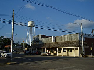
Minonk is a city in Minonk Township, Woodford County, Illinois. The population was 2,078 at the 2010 census, down from 2,168 in 2000. The city is part of the Peoria, Illinois, metropolitan area.

Panola is a village in Woodford County, Illinois, United States. The population was 45 at the 2010 census. It is part of the Peoria, Illinois Metropolitan Statistical Area.
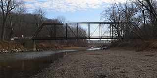
The Mackinaw River is a 130-mile-long (210 km) tributary of the Illinois River in the U.S. state of Illinois. Its watershed covers approximately 1,136 square miles (3,000 km2), and contains some of the most productive agricultural land in the United States. The river itself maintains some of the highest quality streams in the state and provides habitat for 60-70 native fish species and 25-30 species of mussels. Its name, also spelled Mackinac, is derived from the Ojibwe word mikinaak meaning "turtle".

Area codes 309 and 861 are telephone area codes in the North American Numbering Plan (NANP) for the west-central part of the U.S. state of Illinois. The numbering plan area includes cities such as Bloomington, Canton, East Moline, East Peoria, Galesburg, Geneseo, Kewanee, Macomb, Minonk, Moline, Morton, Normal, Pekin, Peoria, Rock Island, Silvis, and many smaller communities in west-central Illinois. Area code 309 was created in 1957 in an split of area code 815. 861 was added to the numbering plan area on February 24, 2023, in formation of an overlay.