
The West Anglia Main Line is one of the two main line railways that operate out of Liverpool Street. It runs generally north through Cheshunt,Broxbourne,Harlow,Bishop's Stortford and Audley End to Cambridge,with branches between serving Stratford,Hertford and Stansted Airport. The line runs along the boundary between Hertfordshire and Essex for much of its length.

Shenfield railway station is on the Great Eastern Main Line in the East of England,serving the suburb of Shenfield,Essex. As well as being a key interchange for medium- and long-distance services on the main line,it is also the western terminus of a branch line to Southend Victoria and one of the two eastern termini of the Elizabeth line. The station is 20 miles 16 chains (32.51 km) down the line from Liverpool Street;it is situated between Brentwood and either Ingatestone on the main line or Billericay on the branch line. Its three-letter station code is SNF.

The Crouch Valley line is a branch line off the Shenfield–Southend line in Essex,in the east of England. It links Wickford in the west to Southminster in the east. During peak hours,trains connect to or from the Great Eastern Main Line at Shenfield,and its London terminus at Liverpool Street.

Billericay railway station is a stop on the Shenfield to Southend Line in the east of England,serving the town of Billericay in the Basildon district of the county of Essex. The vast majority of services on the line connect to the Great Eastern Main Line,linking Southend Victoria station in Southend-on-Sea to Liverpool Street station in London. The Engineer's Line Reference for the line is SSV and the station's three-letter station code is BIC. The platforms have an operational length for 12 carriages.
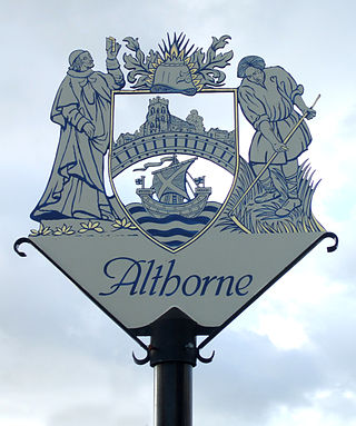
Althorne is a village and civil parish in Essex,England. It is located 21 km (13 mi) east-southeast from the county town and city of Chelmsford. The village is in the district of Maldon district and in the parliamentary constituency of Maldon &East Chelmsford. The village has its own Parish Council.

Hockley railway station is on the Shenfield to Southend Line in the East of England,serving the village of Hockley,Essex. It is 36 miles 1 chain (57.96 km) down the line from London Liverpool Street and is situated between Rayleigh to the west and Rochford to the east. The Engineer's Line Reference for the line is SSV;the station's three-letter station code is HOC. The two platforms have an operational length for 12-coach trains.

Wickford railway station is a junction stop on the Shenfield to Southend Line and also the western terminus of the Crouch Valley Line in the east of England,serving the town of Wickford in the Basildon district of Essex. It is 29 miles 2 chains (46.71 km) down the line from London Liverpool Street and is situated between Billericay to the west and,to the east,Rayleigh on the Southend Line and Battlesbridge on the Crouch Valley Line. The Engineer's Line Reference for the line is SSV,the station's three-letter station code is WIC.

Alresford railway station is on the Sunshine Coast Line,a branch of the Great Eastern Main Line,in the East of England,serving the village of Alresford,Essex. It is 57 miles 63 chains (93.0 km) down the line from London Liverpool Street and is situated between Wivenhoe to the west and Great Bentley to the east. In official literature it is shown as Alresford (Essex) in order to distinguish it from the station of the same name in Hampshire. Its three-letter station code is ALR.

Attleborough railway station is on the Breckland line in the east of England,serving the market town of Attleborough,Norfolk. The line runs between Cambridge in the west and Norwich in the east. Attleborough is situated between Eccles Road and Spooner Row,108 miles 19 chains (174.2 km) from London Liverpool Street via Ely.

Rayleigh railway station is on the Shenfield to Southend Line in the East of England,serving the town of Rayleigh,Essex. It is 33 miles 9 chains (53.29 km) down the line from London Liverpool Street and is situated between Wickford to the west and Hockley to the east. The Engineer's Line Reference for the line is SSV;the station's three-letter station code is RLG. Each of the two platforms has an operational length for 12-coach trains.

Audley End railway station is on the West Anglia Main Line serving the village of Wendens Ambo and the market town of Saffron Walden in Essex,England. It is 41 miles 55 chains (67.1 km) down the line from London Liverpool Street and is situated between Newport and Great Chesterford stations. Its three-letter station code is AUD.
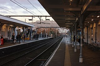
Rochford railway station is on the Shenfield to Southend Line in the East of England,serving the town of Rochford,Essex. It is 38 miles 54 chains (62.24 km) down the line from London Liverpool Street and is situated between Hockley and Southend Airport stations. The Engineer's Line Reference for the line is SSV;the station's three-letter station code is RFD. The platforms have an operational length for 12-coach trains.

Southend Victoria railway station is the eastern terminus of the Shenfield to Southend Line,a branch off the Great Eastern Main Line,in the East of England. It is one of two primary stations that serve the resort city of Southend-on-Sea,Essex;the other is Southend Central on the London,Tilbury and Southend line. It is located 41 miles 42 chains (66.83 km) down the line from London Liverpool Street;the preceding station on the line is Prittlewell. The Engineer's Line Reference for the line is SSV;the station's three-letter station code is SOV. The station has four platforms,each with an operational length for 10-car Class 720 electric multiple units.

Prittlewell railway station is on the Shenfield to Southend Line in the East of England,serving the residential district of Prittlewell in Southend-on-Sea,Essex. It is 40 miles 67 chains (65.72 km) down the line from London Liverpool Street and is situated between Southend Airport and Southend Victoria stations. The Engineer's Line Reference for the line is SSV;the station's three-letter station code is PRL. The platforms have an operational length for 12-coach trains.

Battlesbridge railway station is a stop on the Crouch Valley Line in the East of England,serving the village of Battlesbridge,Essex. It is 31 miles 40 chains (50.7 km) down the line from London Liverpool Street and is situated between Wickford to the west and South Woodham Ferrers. Train services are operated by Greater Anglia.

South Woodham Ferrers railway station is a stop on the Crouch Valley Line in the East of England,serving the town of South Woodham Ferrers,Essex. It is 34 miles (55 km) down the line from London Liverpool Street and is situated between Battlesbridge to the west and North Fambridge to the east. Train services are operated by Greater Anglia.
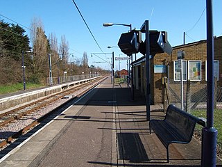
North Fambridge railway station is on the Crouch Valley Line in the East of England,serving the village of North Fambridge,Essex. It is 37 miles 27 chains (60.09 km) down the line from London Liverpool Street and is situated between South Woodham Ferrers to the west and Althorne to the east. Train services are operated by Greater Anglia.
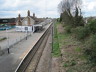
Burnham-on-Crouch railway station is a stop on the Crouch Valley Line in the East of England,serving the town of Burnham-on-Crouch,Essex. It is 43 miles 24 chains (69.68 km) down the line from London Liverpool Street and is situated between Althorne to the west and Southminster to the east. The Engineer's Line Reference for the line is WIS;the station's three-letter station code is BUU. The platform has an operational length for eight-coach trains. The station is managed by Greater Anglia,which also operates all trains serving it. It is located near the Mangapps Railway Museum.
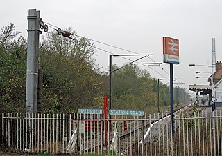
Southminster railway station is the eastern terminus of the Crouch Valley Line in Essex,England;it serves the town of Southminster and other settlements on the Dengie Peninsula. It is 45 miles 42 chains (73.27 km) down the line from London Liverpool Street. The station is managed by Greater Anglia,which operates all services. The Engineer's Line Reference for the line is WIS and the station's three-letter station code is SMN. The platform has an operational length for 8 carriages. The preceding station to the west is Burnham-on-Crouch.

Southminster is a town and civil parish on the Dengie Peninsula in the Maldon district of Essex in the East of England. It lies about 3 miles (4.8 km) north of Burnham-on-Crouch and 10 miles (16 km) south-east of Maldon;it is approximately 52 miles (84 km) east-north-east of London. To the north is the River Blackwater,which is tidal,and,since Roman times,has been the gateway to trading in the area.


