
Wrexham is a city and the administrative centre of Wrexham County Borough in Wales. It is located between the Welsh mountains and the lower Dee Valley, near the border with Cheshire in England. Historically in the county of Denbighshire, and later the county of Clwyd in 1974, it has been the principal settlement of Wrexham County Borough since 1996.

North Wales is a region of Wales, encompassing its northernmost areas. It borders Mid Wales to the south, England to the east, and the Irish Sea to the north and west. The area is highly mountainous and rural, with Snowdonia National Park and the Clwydian Range and Dee Valley, known for its mountains, waterfalls and trails, wholly within the region. Its population is concentrated in the north-east and northern coastal areas, with significant Welsh-speaking populations in its western and rural areas. North Wales is imprecisely defined, lacking any exact definition or administrative structure. It is commonly defined administratively as its six most northern principal areas, but other definitions exist, with Montgomeryshire historically considered to be part of the region.

The Diocese of Saint Asaph is a diocese of the Church in Wales in north-east Wales, named after Saint Asaph, its second bishop.

Alyn and Deeside is a parliamentary constituency represented in the House of Commons of the Parliament of the United Kingdom. The constituency was created in 1983, and it elects one Member of Parliament (MP) by the first-past-the-post method of election.
The Wrexham and Minera Railway or Wrexham and Minera Branch was a railway line in North Wales between the city of Wrexham, the village of Brymbo where it served the Brymbo Steelworks, and the lead mines and limeworks at Minera. A further branch ran from Brymbo to Coed Talon, where it connected with lines to Mold. The system was constructed in several stages between 1844 and 1872, while the various lines making up the system closed in 1952, 1972 and 1982.

The A525 is a major route from Rhyl in Wales to Newcastle-under-Lyme in England. On the way, it passes near to Denbigh, through Ruthin, through Wrexham and near Whitchurch.

Hope is a small village and community in Flintshire, north-east Wales. The village is located approximately 3 miles / 4.5 km from the Wales-England border, on the course of the River Alyn, and less than 5 miles from Wrexham.

Ffrith is a small village in the community of Llanfynydd in Flintshire, north-east Wales.

The River Cegidog is a river in north-east Wales. It flows mainly through Flintshire but towards the end of its course it forms the border between Flintshire and Wrexham County Borough.

Plas Coch is an area of the community of Rhosddu, in the city of Wrexham, Wales. A major retail and educational area of Wrexham, it lies to the north-west of Wrexham city centre. Formerly known as Lower Stansty, the term has fallen out of use in preference for Plas Coch in recent years, likely due to the popular retail area which shares its name.

Cymau is a small village situated in the community of Llanfynydd, Flintshire on the edge of the mountains of north-east Wales. Its name is derived from the Welsh word cymau, an old form of the plural for cwm, "valley" or "hollow".

Cefn-y-bedd is a village in Flintshire, north-east Wales.

The A541 is an A road in North Wales. The road starts on the A525 in Trefnant, between St Asaph and Denbigh, and ends in Wrexham. On the way, it passes the town of Mold. It also passes through many villages. In northern-central Wrexham it joins the B5101 road.
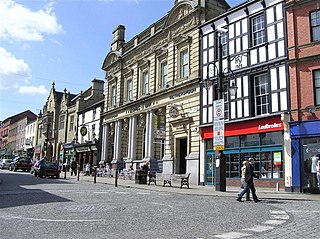
Wrexham city centre is the administrative, cultural and historic city centre of Wrexham, in North Wales and is the area enclosed by the inner ring road of the city. It is the largest shopping area in north and mid Wales, and the administrative centre of Wrexham County Borough. Many of its streets are pedestrianised.

Llanfynydd is a village, local government community and electoral ward in Flintshire, Wales. Its name is derived from the Welsh words llan, and mynydd ("mountain").

Caego is a village in Wrexham County Borough, Wales, immediately to the west of the city of Wrexham in the community of Broughton. It is contiguous with the neighbouring larger village of New Broughton; the main road passing through the centre of the village is the B5101. Its name can perhaps be translated as "the field (cae) of the smith".

Rhydtalog is a small, isolated village in Flintshire, Wales. It lies in hilly country on the border with Denbighshire in the community of Treuddyn.
The North Wales Metro is a rail and bus transport improvement programme in north Wales. Styled as a "Metro", it is conceptually a multi-modal system with a combination of bus, heavy rail, and light rail services. It was initially focused on linking major settlements and employment areas of the north-east of Wales with the North West of England, with its hubs located in Wrexham, Chester and Deeside, although the programme has since expanded, with proposals extending to Anglesey in the north-west of Wales. The existing Borderlands line forms a core rail component of the network, where projects to increase connections, integrated access, and service frequency between Wrexham, Deeside and Liverpool are centred upon. The proposals were put forward in 2016 as is part of Welsh Labour's plan for north Wales. Labour has pledged to open the system by 2035. The proposals were included in the 2018 Wales & Borders franchise contest. It is the second of the three regional metros proposed by the Welsh Government to go ahead, after the South Wales Metro, and before the Swansea Bay and West Wales Metro. The project is described to be in its initial phases.

Newbridge is a village in Wrexham County Borough, Wales. The village is within the community of Cefn, to the south-east of Cefn Mawr. Newbridge is bounded to the west by the Shrewsbury–Chester railway line and the Newbridge Railway Viaduct which crosses the River Dee, which meanders to the south and east of the village. The Clwydian Range and Dee Valley AONB since 2011 borders the village to the south, as does the Wynnstay estate, and Tŷ Mawr Country Park is on the other side of the viaduct to the west.
