
Brasstown Bald is the highest point in the U.S. state of Georgia. It is located in the northeastern part of the state in the Blue Ridge Mountains on the border between Towns and Union counties south of the city of Hiawassee. The mountain is known to the native Cherokee people as Enotah.

The Hudson Highlands are mountains on both sides of the Hudson River in New York state lying primarily in Putnam County on its east bank and Orange County on its west. They continue somewhat to the south in Westchester County and Rockland County, respectively. The highlands are a subrange of the Appalachian Mountains.

Hightower Bald, with an elevation of 4,568 feet (1,392 m) is the fourth-highest peak in the US state of Georgia. It is located in Towns County, Georgia at the North Carolina state line and is within the boundaries of the Southern Nantahala Wilderness of the Chattahoochee National Forest.

Coosa Bald, with an elevation of 4,280 feet (1,300 m), is tied with Double Spring Knob as the tenth-highest peak in Georgia. It is located in Union County and is the third-highest mountain in the county, behind Blood Mountain and Slaughter Mountain. Coosa Bald is located in the Chattahoochee National Forest and its peak is crossed by the Duncan Ridge Trail, a trail that connects with the Benton MacKaye Trail and the Appalachian Trail.

Roan Mountain is a 6,277 ft (1,913 m) mountain straddling the North Carolina/Tennessee border in the Unaka Range of the Southern Appalachian Mountains in the Southeastern United States. The range's highpoint, Roan is clad in a dense stand of Southern Appalachian spruce-fir forest, and includes the world's largest natural rhododendron garden, and the longest stretch of grassy bald in the Appalachian range. The Roan Highlands also contain the highest quality remaining stretch of Fraser fir forest throughout the tree's entire range. The Cherokee National Forest and Pisgah National Forest converge atop the mountain, with Roan Mountain State Park located near its northern base. The Appalachian Trail traverses most of the Roan's crest. The Roan High Knob Shelter is the highest back-country shelter on the entire 2,174-mile (3,499 km) trail.

Rocky Peak Ridge is a mountain in the Adirondacks in the U.S. state of New York. It is the 20th-highest of the Adirondack High Peaks, with an elevation of 4,420 feet (1,350 m). It is located in the Giant Mountain Wilderness Area, in the town of Keene in Essex County. The mountain is named for its appearance as a rocky ridge to the east of the better-known Giant Mountain. Other early names for the mountain included "Giant's Wife", "Bald Mountain", and "Bald Peak", the last of which now belongs to a shorter nearby peak. The earliest recorded ascent of the mountain was made by trail guides Fred J. Patterson and Sam Dunning in 1878. A major forest fire in 1903 burned the topsoil from the top of the mountain and left it with its distinctive bare ridge.

Silers Bald is a mountain in the western Great Smoky Mountains, located in the southeastern United States with the Great Smoky Mountains National Park. Its proximity to Kuwohi and its location along the Appalachian Trail make it a popular hiking destination.
Boundary Bald Mountain is a mountain located in Somerset County, Maine, about 7.5 mi (12.1 km) southeast of the Canada–US border with Quebec. Boundary Bald Mountain is flanked to the east by Ironbound Mountain, and to the west by Sandy Bay Mountain.

The Great Balsam Mountains, or Balsam Mountains, are in the mountain region of western North Carolina, United States. The Great Balsams are a subrange of the Blue Ridge Mountains, which in turn are a part of the Appalachian Mountains. The most famous peak in the Great Balsam range is Cold Mountain, which is the centerpiece of author Charles Frazier's bestselling novel Cold Mountain. Other notable peaks include Richland Balsam, which is the highest peak in the range, Black Balsam Knob, and Mount Pisgah.

Bald Peak State Scenic Viewpoint is a state park located atop Bald Peak located in Yamhill County, in the United States. The day use only park offers picnic tables and a hiking trail for views of the Willamette Valley and the Cascade Range. The state of Oregon acquired the 26 acres (11 ha) in 1931 after Yamhill and Washington counties requested a park from the state.

Berlin Mountain is a 2,818-foot-tall (859 m) prominent peak in the Taconic Mountains of western New England and is located adjacent to Massachusetts's border with New York State. It is the highest point in Rensselaer County. The summit and west side of the mountain are located in New York; the east side lies within Williamstown, Massachusetts. The mountain is a bald, notable for its grassy summit and expansive views of the Hudson River Valley to the west. The 37-mile (60 km) Taconic Crest Trail traverses the mountain. Several other hiking trails approach the summit from the east. Much of the upper slopes and summit are within protected conservation land. Historically the lower slopes of the mountain were farmed heavily throughout the 19th Century. In addition to agriculture, there are several remnants of charcoal kilns located on the mountain that produced fuel for iron smelting.
White Rock, 2,550 feet (780 m), is the high point on a 7 mi (11 km) ridgeline in the Taconic Mountains. The ridge is located in the tri-state corner of New York, Massachusetts, and Vermont in the towns of Petersburgh, Williamstown, and Pownal. The ridge has several distinct knobs; those with names are, from south to north: White Rocks, 2,365 feet (721 m); Smith Hill, 2,330 feet (710 m); White Rock, the high point 2,550 feet (780 m); and Bald Mountain 2,485 feet (757 m). The Snow Hole, located along the ridgeline between Bald Mountain and the White Rock, is a crevasse in which snow can be found well into the summer.

Shenipsit State Forest is a state forest located in northeastern Connecticut with 11 parcels scattered between the towns of Somers, Ellington, and Stafford. The forest's headquarters is home to the Civilian Conservation Corps Museum, which houses memorabilia from CCC camps throughout the eastern United States. The forest is managed for forestry products and offers various recreational pursuits.

Bald Mountain is a high and prominent mountain summit in the Front Range of the Rocky Mountains of North America. The 13,690-foot (4,173 m) thirteener is located in Arapaho National Forest, 5.5 miles (8.9 km) southeast of the Town of Breckenridge in Summit County, Colorado, United States.
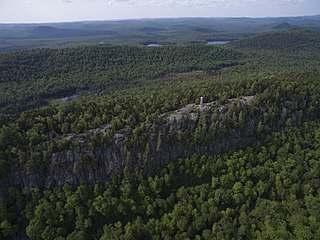
Bald Mountain, or Rondaxe Mountain, is a part of the Adirondack Mountains in the U.S. state of New York. The trail leading up the mountain is a popular hike, likely due to its proximity to tourist towns. The mountain is also home to the Rondaxe Mountain Fire Tower, which contributes to the trail's popularity.
Bald Mountain is a mountain in Bergen County, New Jersey, just south of the New York state line. The peak rises to 1,152 feet (351 m). It is part of Ringwood State Park in the Ramapo Mountains. This summit is the highest elevation in Bergen County.
Bald Mountain is a 1,647-foot-tall (502 m) mountain in Lewis County in the state of New York. It is located north of Oswegatchie Camp in the town of Croghan. In 1919, a 47-foot-tall (14 m) steel fire lookout tower was built on the mountain. Due to increased use of aerial detection, the tower was closed at the end of the 1970 season. The tower was later knocked over by the private owner due to liability concerns. The public can visit the site, but due to no tower there is no view.
Bald Mountain is a mountain located in the Catskill Mountains of New York west-northwest of Gilboa. Mount Jefferson is located north-northwest, and Mine Hill is located north of Bald Mountain.
Bald Mountain is a mountain in Sullivan County, New York. It is located south of Debruce. Rattle Hill is located northwest and Gray Hill is located west-northwest of Bald Mountain.

Big Bald is a mountain on the border of Yancey County, North Carolina and Unicoi County, Tennessee. located along the Appalachian Trail. at an elevation of 5,516 feet (1,681 m), it is the highest peak in the Bald Mountains, which are part of the larger Blue Ridge Mountains subrange of the Appalachian Mountains.

