
Putnam County is a county located in the U.S. state of New York. As of the 2020 census, the population was 97,668. The county seat is Carmel. Putnam County formed in 1812 from Dutchess County and is named for Israel Putnam, a hero in the French and Indian War and a general in the American Revolutionary War.

Pea Ridge is a city in Benton County, Arkansas, United States. The name Pea Ridge is derived from a combination of the physical location of the original settlement of the town, across the crest of an Ozark Mountains ridge, and for the hog peanuts or turkey peas that had been originally cultivated by Native American tribes centuries before European settlement, which later helped to provide basic subsistence once those pioneer settlers arrived.

Patterson is a town in Putnam County, New York, United States. The town is in the northeastern part of the county. Interstate 84 passes through the southwestern section of the town. The population was 12,023 at the 2010 census. The town is named after early farmer Matthew Paterson. The reason Patterson was spelled with two "t"s was due to the looseness with which Paterson spelled his own last name.

Events from the year 1782 in Canada.
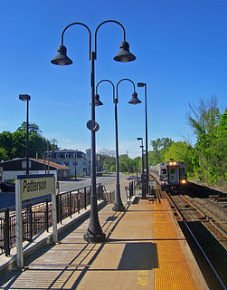
Patterson station is a commuter rail stop on the Metro-North Railroad's Harlem Line, located in Patterson, New York. Trains leave for New York City every two hours, and about every 30 minutes during rush hour. It is 60.2 miles from Grand Central Terminal and travel time to Grand Central is approximately one hour, 42 minutes.

Patterson Creek Mountain is a mountain ridge that forms the border between Mineral and Hampshire counties and Grant and Hardy Counties in West Virginia's Eastern Panhandle. The mountain's namesake, Patterson Creek, parallels its western flank. The southern end of the Patterson Creek Mountain is near the confluence of Lunice Creek and the South Branch Potomac River and its northern end is located southwest of Springfield. The mountain reaches its highest elevation at Charles Knob.
Mill Creek is an 8.7-mile-long (14.0 km) tributary stream of Patterson Creek in Mineral County, West Virginia. It is also known as Mill Run.
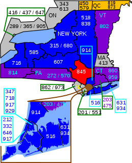
Area code 845 is a telephone area code in the North American Numbering Plan (NANP) for the U.S. state of New York. The numbering plan area comprises the mid- and lower Hudson Valley, specifically Orange, Putnam, Rockland, and Ulster counties, and parts of Columbia, Delaware, Dutchess, Greene, and Sullivan counties. The area code was created on June 5, 2000, by an area code split from most of the territory of area code 914, which was retained by Westchester County.
New York State Route 311 (NY 311) is a state highway located entirely within Putnam County, New York, in the United States. It begins at NY 52 in Lake Carmel, and intersects Interstate 84 (I-84) shortly thereafter. It crosses NY 164 and NY 292 as it heads into the northeastern part of the county, finally curving east to reach its northern terminus at NY 22 just south of the Dutchess County line. The route passes several historical sites.

Plateau Mountain is located in the town of Hunter in Greene County, New York, United States. It is part of the Devil's Path range of the Catskill Mountains. Plateau has a two-mile-long (3.2 km) summit ridge above 3,500 feet (1,100 m). The highest point, at least 3,840 feet (1,170 m), is at the southeast end, facing Sugarloaf Mountain to the east across Mink Hollow Notch. It is the 12th-highest peak in the range Devils Tombstone is located west of Plateau Mountain. The northwest end faces Hunter Mountain to the west across 1,400-foot deep (430 m) Stony Clove Notch.
Daniel Mallory Stephens was a local and state politician and member of the New York State Assembly from Patterson, New York.
White Rock, 2,550 feet (780 m), is the high point on a 7 mi (11 km) ridgeline in the Taconic Mountains. The ridge is located in the tri-state corner of New York, Massachusetts, and Vermont in the towns of Petersburgh, Williamstown, and Pownal. The ridge has several distinct knobs; those with names are, from south to north: White Rocks, 2,365 feet (721 m); Smith Hill, 2,330 feet (710 m); White Rock, the high point 2,550 feet (780 m); and Bald Mountain 2,485 feet (757 m). The Snow Hole, located along the ridgeline between Bald Mountain and the White Rock, is a crevasse in which snow can be found well into the summer.

Cherokee is a former gold mining community in Nevada County, California. As explained below, it has also been known as Patterson, Melrose and Tyler. It is located on the San Juan Ridge about 4 miles east of North San Juan. Its elevation is 2,516 ft (767 m) above sea level.

The John and Eliza Barr Patterson House is a private house located at 6205 N. Ridge Road in Canton, Michigan, United States. It was listed on the National Register of Historic Places in 2000.

Pound Ridge Historic District is a national historic district located at Pound Ridge, Westchester County, New York. The district contains 46 contributing buildings and encompasses almost all of the hamlet. The majority of the buildings in the district date between 1780 and 1852. The earliest building was built in 1758 and is the Capt. Joseph Lockwood House. Notable buildings include: Methodist Episcopal (Community) Church (1833), Patterson Memorial Presbyterian Church, Presbyterian Lecture Hall, Parker Store (1906), Pound Ridge Village School, Aaron Wood's Mill, Partridge Thatcher House (1788), Maj. Ebenezer Lockwood House, Alsop Hunt Lockwood House (1840), and Solomon Lockwood House.

Bellvale Mountain is a mountain range located near Bellvale in Orange County, New York. It is a continuation of Bearfort Mountain in New Jersey. The Appalachian Trail is located along the ridge of the mountain. Puddingstone of the Skunnemunk Conglomerate is visible along the ridge.

Sugarloaf Mountain is a 900-foot (270 m) peak located in the town of Fishkill near the Hudson River and Breakneck Ridge. One of several similarly named mountains in the U.S. state of New York, it is part of the Hudson Highlands, located entirely within Hudson Highlands State Park.

Bald Mountain is a mountain located in Greene County, New York east-southeast of Prattsville, New York. Bald Mountain is located on Patterson Ridge. It drains south into Schoharie Creek and north into Batavia Kill.
Maben Hill is a mountain located in Greene County, New York east-southeast of Prattsville, New York. Maben Hill is located south of Patterson Ridge. It drains south and east into Schoharie Creek.

