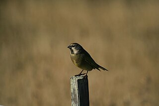
The gentoo penguin is a penguin species in the genus Pygoscelis, most closely related to the Adélie penguin and the chinstrap penguin. The earliest scientific description was made in 1781 by Johann Reinhold Forster with a type locality in the Falkland Islands. The species calls in a variety of ways, but the most frequently heard is a loud trumpeting, which the bird emits with its head thrown back.

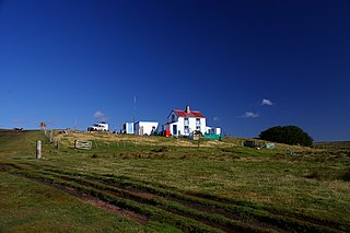
Lively Island is the largest of the Lively Island Group of the Falkland Islands, The island group lies east of East Falkland. Lively Island is the largest rat-free island in the Falklands, hence its importance to birdlife. The island is owned by Steven and Chris Poole who also run a sheep farm on the island.

Bleaker Island is one of the Falkland Islands, lying off south east Lafonia. The name is a corruption of "Breaker Island" due to the waves that break on it. It was also known as "Long Island" at one point.

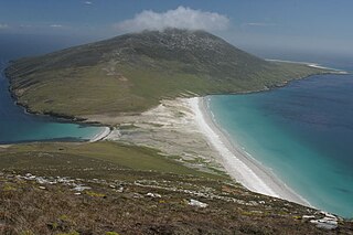
Carcass Island is the largest of the West Point Island Group of the Falkland Islands.
Saunders Island is the fourth largest of the Falkland Islands, lying north west of West Falkland. The island is run as a sheep farm.
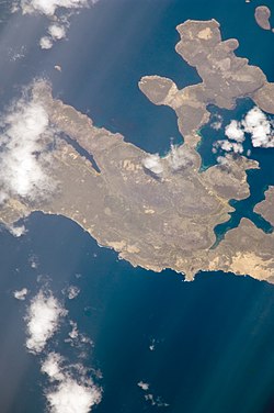
Keppel Island is one of the Falkland Islands, lying between Saunders and Pebble islands, and near Golding Island to the north of West Falkland on Keppel Sound. It has an area of 3,626 hectares and its highest point, Mt. Keppel, is 341 metres (1,119 ft) high. There is a wide, flat valley in the centre of the island with several freshwater lakes. The central valley rises steeply to the south-west, west and north. The north-east is low-lying, with a deeply indented coastline.

The Jason Islands are an archipelago in the Falkland Islands, lying to the far north-west of West Falkland. Three of the islands, Steeple Jason, Grand Jason and Clarke's Islet, are private nature reserves owned by the Wildlife Conservation Society of New York City. Other islands in the group are National Nature Reserves owned by the Falkland Islands Government.

Pebble Island is one of the Falkland Islands, situated north of West Falkland. It is possibly named after the peculiarly spherical pebbles found at its western tip.

Sea Lion Island is the largest of the Sea Lion Island Group of the Falkland Islands. It is 9 km2 (3 sq mi) in area. and lies 14 km (9 mi) southeast of Lafonia. It was designated a Ramsar site on 24 September 2001, and as an Important Bird Area. In 2017 the island was designated as a National Nature Reserve.

New Island is one of the Falkland Islands, lying north of Beaver Island. It is 238 km (148 mi) from Stanley and is 13 km (8.1 mi) long with an average width of 750 m (820 yd). The highest point is 226 metres (741 ft). The northern and eastern coasts have high cliffs but the eastern coasts are lower lying, with rocky shores and sandy bays. There are several smaller offshore islands in the group; North Island and Saddle Island have high cliffs but Ship Island and Cliff Knob Island are lower lying.

Beauchene Island is the southernmost of the Falkland Islands, lying about 54 kilometres (34 mi) south of Porpoise Point in Lafonia. It was discovered in 1701 by Jacques Gouin de Beauchêne, after whom it was named.

The Passage Islands are a group of four islands in the Falkland Islands of the South Atlantic Ocean. They lie off Dunnose Head, West Falkland, at the mouth of King George Bay.
Volunteer Point is a headland on the east coast of East Falkland, in the Falkland Islands, north-northeast of Stanley, and east of Johnson's Harbour and Berkeley Sound. It lies at the end of a narrow peninsula, which protects Volunteer Lagoon. It received its name in 1815, when the sealing ship Volunteer left a boat's crew there to collect seal skins while it went in search of opportunities elsewhere. Four years later, on 13 February 1820, the French research vessel L'Uranie struck a submerged rock just off the point but stayed afloat long enough to be beached in Berkeley Sound. All on board survived, including the Captain's wife, Rose de Freycinet, who recorded the incident in her diary.

Kidney Island so called due to its shape, is a small island with a land area of 33 hectares, to the east of East Falkland, not far from Stanley. It lies is at the east end of Berkeley Sound near Kidney Cove, and is separated from Port William by Menguera Point. It is a nature reserve and, unlike most of the main islands, is still covered in tussac grass. Its wildlife includes penguins and sea lions. It is one of only three places in the archipelago where king penguins breed; the others are Saunders Island and Volunteer Point on East Falkland.
Bull Point is the most southerly part of East Falkland, and of the two main islands of the Falklands. It is at the far end of Lafonia, near Eagle Passage, and forms part of the west shore of the Bay of Harbours. A 1500 ha tract has been identified by BirdLife International as an Important Bird Area (IBA).

The Madder Cliffs are reddish rock cliffs which form the north side of the entrance to Suspiros Bay, at the west end of Joinville Island, Antarctica. They rise steeply from the sea to about 305 metres (1,000 ft). The cliffs were surveyed by the Falkland Islands Dependencies Survey in 1953–54. The name, given in 1956 by the UK Antarctic Place-Names Committee, is descriptive of the red colour of the rocks, madder being a red vegetable pigment.

Bertha's Beach Important Bird Area comprises 3,300 hectares of coastal wetlands at the entrance to Choiseul Sound, on the east coast of East Falkland, in the Falkland Islands. It lies about 8 kilometres (5.0 mi) south-east of Mount Pleasant Airport and 40 km south-west of Stanley. It has been identified by BirdLife International as an Important Bird Area (IBA) because of its significancer for a variety of migratory waders and other waterbirds. Overlapping it is the 4000 ha Bertha's Beach Ramsar site, recognising it as a wetland of international importance.

The Elephant Cays are a group of small islands lying towards the southern end of Falkland Sound, just to the north-west of Speedwell Island, in the Falkland Islands of the South Atlantic Ocean. The group, with a collective area of 248 ha includes Golden Knob, Sandy Cay, West, Southwest and Stinker Islands. It has been identified by BirdLife International as an Important Bird Area (IBA).

Hope Harbour is an inlet at the north-west of West Falkland in the Falkland Islands of the South Atlantic Ocean. About 4 km long and 1.3 km wide, it is sheltered by the promontory of Grave Cove Camp in the south, a narrow ridge terminating in Hope Point to the north, Bramble Point Camp to the east, and West Point Island at its entrance to the west. Carcass Island lies 8 km north-east of Hope Point.
Seal Bay is a bay, about 1 km across, on the rugged and exposed north coast of East Falkland in the Falkland Islands of the South Atlantic Ocean. It lies some 40 km north-west of Stanley.