
Watauga County is a county located in the U.S. state of North Carolina. As of the 2020 census, the population was 54,086. Its county seat and largest community is Boone. The county is in an exceptionally mountainous region, known as the High Country. It is the home of Appalachian State University, which has approximately 21,570 students as of Fall 2024. Watauga County comprises the Boone, NC Micropolitan Statistical Area.
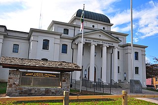
Avery County is a county located in the U.S. state of North Carolina. As of the 2020 census, the population was 17,806. The county seat is Newland. The county seat was initially established in Elk Park when the county was first formed, but was moved to Newland upon completion of the courthouse in 1912. Founded in 1911, it is the youngest of North Carolina's 100 counties.

Indian Lake is a town in Hamilton County, New York, United States. The population was 1,352 at the 2010 census. The name is from a lake of the same name that is largely inside the town. There are no permanent stop lights in the town. Law enforcement is provided by New York State Troopers and Hamilton County Sheriff's Office.

Beech Mountain is a town in both Avery and Watauga counties in the U.S. state of North Carolina. At the 2020 census, the town population was 675. The town is located atop Beech Mountain and is the highest town east of the Rocky Mountains at 5,506 ft (1,678 m) in elevation. The nearest municipality at a higher elevation is Des Moines, New Mexico, some 1,220 miles away.

Western North Carolina is the region of North Carolina which includes the Appalachian Mountains; it is often known geographically as the state's Mountain Region. It contains the highest mountains in the Eastern United States, with 125 peaks rising to over 5,000 feet in elevation. Mount Mitchell at 6,684 feet, is the highest peak of the Appalachian Mountains and mainland eastern North America. The population of the 23 most commonly associated counties for the region, as measured by the 2020 U.S. Census, is 1,149,405. The region accounts for approximately 11% of North Carolina's total population.

Blue Knob is a summit in the eastern United States with a broad dome that is the northernmost 3,000-footer in the Allegheny Mountains. It is the highest point in Bedford County, Pennsylvania.

Mullaghmeen, at 258 metres (846 ft), is the county top for Westmeath in Ireland, and is the lowest county top in Ireland. Mullaghmeen is located in the Mullaghmeen Forest, known for having the largest planted beech forest in Europe.

Vly Mountain is a mountain located in the town of Halcott, New York, United States in Greene County. The mountain is part of the Catskill Mountains. Vly Mountain is flanked to the northwest by Bearpen Mountain, to the east by Vinegar Hill, to the northeast by Kipp Hill, and to the southeast by Beech Ridge.
Beech Hill may refer to the following places:

Beech Mountain is a mountain in the North Carolina High Country and wholly in the Pisgah National Forest. Its elevation reaches 5,506 feet and generates feeder streams for the Elk River. Nestled on the top is the Town of Beech Mountain.
Rich Mountain is a mountain located in the North Carolina High Country, roughly 3 miles (4.8 km) northwest of the town of Boone. Its elevation reaches 4,748 feet (1,447 m).
Beech Hill is an unincorporated community in Mason County, West Virginia, United States.

Orviston is an unincorporated community and census-designated place (CDP) in Curtin Township, Centre County, Pennsylvania, United States. As of the 2010 census, the population was 95. It is located in far northern Centre County, near the Clinton County border. Beech Creek runs through the center of the town, flowing southeast towards Bald Eagle Creek in the West Branch Susquehanna River watershed.
Beech Ridge is a ridge located in Greene County, New York southwest of Lexington, New York. Located to the northwest is Vly Mountain and to the north of Vinegar Hill. Beech Ridge drains north into Beech Ridge Brook, east into West Kill and south into Condon Hollow.
Middle Mountain is a mountain located in the Catskill Mountains of New York east-southeast of Downsville. Mary Smith Hill is located west of Middle Mountain and Beech Hill is located east.
Rattle Hill is a mountain in Sullivan County, New York. It is located north-northwest of Grooville. Beech Mountain is located east-northeast, Burnt Hill is located west-southwest and Gray Hill is located south-southwest of Rattle Hill.
Slawson Mountain is a mountain in Sullivan County, New York. It is located east of Willowemoc. Blue Hill is located east and Beech Mountain is located northwest of Slawson Mountain.

The Oconaluftee River drains the south-central Oconaluftee valley of the Great Smoky Mountains in Western North Carolina before emptying into the Tuckasegee River. The river flows through the Qualla Boundary, a federal land trust that serves as a reserve for the Eastern Band of the Cherokee, the only federally recognized tribe in North Carolina. They bought the land back from the federal government in the 1870s, after having been pushed off and forced to cede it earlier in the 19th century. Several historic Cherokee towns are known to have been located along this river.
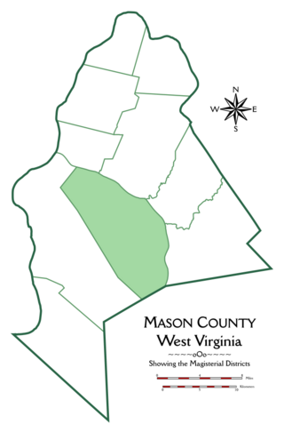
Arbuckle Magisterial District is one of ten magisterial districts in Mason County, West Virginia, United States. The district was originally established as a civil township in 1863, and converted into a magisterial district in 1872. In 2020, Arbuckle District was home to 1,054 people.

