
Monmouth County is a county located in the central portion of the U.S. state of New Jersey. It is bordered to its west by Mercer and Middlesex Counties, to its south by Ocean County, to its east by the Atlantic Ocean, and to its north by the Raritan Bay. Monmouth County's geographic area comprises 30% water. The county is part of the Jersey Shore region of the state. It has also been categorized under the Central Jersey region, though it was not among the four counties explicitly listed as included in Central Jersey as part of legislation signed into law in 2023.
Murray Hill is an unincorporated community located within portions of both Berkeley Heights and New Providence, located in Union County, in the northern portion of the U.S. state of New Jersey.

Deerfield is a town in Oneida County, New York, United States. The population was 4,273 at the 2010 census.

The Texas Hill Country is a geographic region of Central and South Texas, forming the southeast part of the Edwards Plateau. Given its location, climate, terrain, and vegetation, the Hill Country can be considered the border between the American South and Southwest. The region represents the very remote rural countryside of Central Texas, but also is home to growing suburban neighborhoods and affluent retirement communities.

Saint Georges is an unincorporated town and former municipality situated on the Chesapeake and Delaware Canal in New Castle County, Delaware, United States, approximately midway between the Delaware River and Chesapeake Bay.
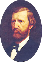
Peter Hansborough Bell was an American military officer and politician who served as the third Governor of Texas and represented the state for two terms in the United States House of Representatives.

The Simi Hills are a low rocky mountain range of the Transverse Ranges in eastern Ventura County and western Los Angeles County, of southern California, United States.
Free Acres is an unincorporated community located along the border of Berkeley Heights in Union County and Watchung in Somerset County, in the U.S. state of New Jersey. Free Acres was created in 1910 as a social experiment by Bolton Hall, an Irish-born New York entrepreneur, reformer and follower of Leo Tolstoy. Hall believed in economist Henry George's idea of single taxation, under which residents pay a land value tax to the community based on the value of the land alone, and in turn, the community pays a lump sum to the municipality.
Ingraham Hill is a mountain in the Southern Tier of New York. It is located south-southwest of Binghamton in Broome County. The mountain contains the television and radio broadcast towers for the surrounding metropolitan area. The summit rises to an elevation of 1,824 feet (556 m). These towers include TV stations WBNG, WICZ, WIVT, WSKG-TV and radio stations WNBF, WAAL, WWYL and many more. The towers are visible throughout the region.

Berlin Mountain is a 2,818-foot-tall (859 m) prominent peak in the Taconic Mountains of western New England and is located adjacent to Massachusetts's border with New York State. It is the highest point in Rensselaer County. The summit and west side of the mountain are located in New York; the east side lies within Williamstown, Massachusetts. The mountain is a bald, notable for its grassy summit and expansive views of the Hudson River Valley to the west. The 37-mile (60 km) Taconic Crest Trail traverses the mountain. Several other hiking trails approach the summit from the east. Much of the upper slopes and summit are within protected conservation land. Historically the lower slopes of the mountain were farmed heavily throughout the 19th Century. In addition to agriculture, there are several remnants of charcoal kilns located on the mountain that produced fuel for iron smelting.

Rum Hill is a mountain located in Central New York Region of New York northwest of the Hamlet of Pierstown. Red House Hill is located southeast, Metcalf Hill is located south, Allen Lake and Mohegan Hill are located north-northwest and Otsego Lake is located east of Rum Hill.
Red House Hill is a mountain in the Central New York Region of the State of New York, United States. It is located south-southwest of the Hamlet of Springfield Center, New York, west of Hutter Point and Six Mile Point of Otsego Lake, and southeast of Rum Hill. Mohican Brook flows eastward along the southern edge of the hill.
Fitch Hill is a mountain located in Central New York Region of New York by Pierstown. Fitch Hill is named after the Fitch family who were early settlers in the area.
Klock Hill is a mountain located in Central New York region of New York southwest of Burlington, New York.
Dairy Hill is a 1,844-foot-tall (562 m) summit located in Central New York Region of New York located in the Town of Norway in Herkimer County, southeast of Norway. The mountain is the former location of a 79-foot-6-inch-tall (24.23 m) steel fire lookout tower.
Frost Hill is a mountain in the Finger Lakes Region of New York. It is located west of Bristol Springs in Ontario County. At an elevation of 2,284 feet (696 m), the mountain is the highest point in Ontario County. It is about 1.25 miles (2.01 km) southwest of the 2,150-foot (660 m) Worden Hill, where Bristol Mountain Ski Resort is.
Morgan Hill is a mountain in the central part of the state of New York. It is located north-northeast of Truxton in Cortland County with a small portion in Onondaga County. The portion of the mountain within Onondaga County is the highest point in the county.
Beech Hill is a summit in Herkimer County, New York. It is located north-northwest of Frankfort in the Town of Schuyler. Bell Hill is located north-northwest of Beech Hill.
Van Loan Hill is a mountain in Greene County, New York. It is located in the Catskill Mountains southwest of Maplecrest. Round Hill is located west, Elm Ridge is located north-northeast, and East Jewett Range is located south of Van Loan Hill.
Leonard Hill is a 2,592-foot-tall (790 m) mountain in Schoharie County, New York. It is located east-southeast of North Blenheim. Safford Hill is located northwest and Hubbard Hill is located southeast of Leonard Hill. In 1948, the Conservation Commission built an 80-foot-tall (24 m) steel fire lookout tower on the mountain. The tower ceased fire watching operations at the end of the 1988 season and was officially closed in early 1989. The tower remains on the summit, but is closed to the public. A local group is planning to restore the tower and reopen it to the public.

