Broken River, Queensland

Last updated

Broken River
Queensland
Broken River 2, Queensland. - Flickr - Steven Penton.jpg
Broken River flowing through the locality of Broken River, 2021
Australia Queensland location map.svg
Red pog.svg
Broken River
Coordinates 21°10′01″S148°30′36″E / 21.1669°S 148.51°E / -21.1669; 148.51 (Broken River (centre of locality))
Population18 (2021 census) [1]
 • Density3.10/km2 (8.04/sq mi)
Postcode(s) 4757
Area5.8 km2 (2.2 sq mi)
Time zone AEST (UTC+10:00)
Location
LGA(s) Mackay Region
State electorate(s) Mirani
Federal division(s) Capricornia
Suburbs around Broken River:
Eungella Eungella Netherdale
Eungella Broken River Crediton
Crediton Crediton Crediton

Broken River is a rural locality in the Mackay Region, Queensland, Australia. [2] In the 2021 census, Broken River had a population of 18 people. [1]

Contents

Geography

Rain forest, 2021 Rain forest, Broken River, Queensland. (51188484922).jpg
Rain forest, 2021

The watercourse Broken River rises in the Clarke Range in Crediton to the south-east, entering the locality from the locality from the south-east, then flowing west through the locality, exiting to the west (Eungella). It subsequently flows through the Eungella Dam and ultimately is a tributary of the Bowen River. [3]

The Eungella Dam Road enters the locality from the north-west (Eungella), forms part of the western boundary of the locality, before crossing through the locality, exiting to the south (Crediton). [4]

The north, east, and south of the locality is within the Eungella National Park, which extends in neighbouring Eungella, Netherdale, and Crediton. [5] Apart from this protected area, the land use is predominantly grazing on native vegetation. [5]

Demographics

In the 2016 census, Broken River had a population of 22 people. [6]

In the 2021 census, Broken River had a population of 18 people. [1]
Education

There are no schools in Broken River. The nearest government primary school is Eungella State School in neighbouring Eungella to the north. The nearest government secondary school is Mirani State High School in Mirani to the east. [7]

Attractions

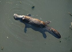
Platypus in the Broken River, 2004 Platypus BrokenRiver QLD Australia.jpg
Platypus in the Broken River, 2004

The Broken River visitor area of the Eungella National Park is on the Eungella Dam Road immediately to the south of its crossing of the Broken River ( 21°10′06″S148°30′17″E / 21.1683°S 148.5048°E / -21.1683; 148.5048 (Broken River visitor area) ). It offers platypus viewing and walking tracks, with picnic, BBQ, and camping areas. [8]

Broken River Mountain Resort is a commercial accommodation provider at 524 Eungella Dam Road, immediately north of the Broken River adjacent to the Eungella National Park ( 21°10′03″S148°30′15″E / 21.1675°S 148.5043°E / -21.1675; 148.5043 (BROKEN RIVER MOUNTAIN RESORT) ). [9] [10]

References

  1. 1 2 3 Australian Bureau of Statistics (28 June 2022). "Broken River (SAL)". 2021 Census QuickStats. Retrieved 28 February 2023. OOjs UI icon edit-ltr-progressive.svg
  2. "Broken River – locality in Mackay Region (entry 46866)". Queensland Place Names. Queensland Government . Retrieved 29 October 2019.
  3. "Layers: Locality; Mountains and ranges; Contours; Watercourses". Queensland Globe. Queensland Government. Archived from the original on 19 December 2017. Retrieved 5 June 2025.
  4. "Layers: Locality; Road and rail; Railways; Railway stations". Queensland Globe. Queensland Government. Archived from the original on 19 December 2017. Retrieved 5 June 2025.
  5. 1 2 "Layers: Locality; Protected areas and forests; Land use". Queensland Globe. Queensland Government. Archived from the original on 19 December 2017. Retrieved 5 June 2025.
  6. Australian Bureau of Statistics (27 June 2017). "Broken River (SSC)". 2016 Census QuickStats. Retrieved 20 October 2018. OOjs UI icon edit-ltr-progressive.svg
  7. "Layers: Locality; Schools and school catchments". Queensland Globe. Queensland Government. Archived from the original on 19 December 2017. Retrieved 5 June 2025.
  8. "Broken River visitor area map, Eungella National Park" (PDF). Parks and forests. Queensland Government. January 2025. Archived (PDF) from the original on 3 April 2025. Retrieved 5 June 2025.
  9. "Building points - Queensland". Queensland Open Data. Queensland Government. 17 November 2020. Archived from the original on 25 November 2020. Retrieved 25 November 2020.
  10. "Broken River Mountain Resort". Broken River Resort. Retrieved 5 June 2025.