
San Bernardino County, officially the County of San Bernardino and sometimes abbreviated as S.B. County, is a county located in the southern portion of the U.S. state of California, and is located within the Inland Empire area. As of the 2020 U.S. Census, the population was 2,181,654, making it the fifth-most populous county in California and the 14th-most populous in the United States. The county seat is San Bernardino.

Redlands is a city in San Bernardino County, California, United States. As of the 2020 census, the city had a population of 73,168, up from 68,747 at the 2010 census. The city is located approximately 45 miles (72 km) northwest of Palm Springs and 63 miles (101 km) east of Los Angeles.

San Bernardino is a city in and the county seat of San Bernardino County, California, United States. Located in the Inland Empire region of Southern California, the city had a population of 222,101 in the 2020 census, making it the 18th-largest city in California. San Bernardino is the economic, cultural, and political hub of the San Bernardino Valley and the Inland Empire. The governments of El Salvador, Guatemala, and Mexico have established the metropolitan area's only consulates in the downtown area of the city. Additionally, San Bernardino serves as an anchor city to the 3rd largest metropolitan area in California and the 12th largest metropolitan area in the United States; the San Bernardino–Riverside MSA. Furthermore, the city's University District serves as a college town, as home to California State University, San Bernardino.

Angelus Oaks is an unincorporated community in San Bernardino County, California, United States, and has a population of 535 as of the 2010 U.S. Census, up from an estimated population of 312 in 2000. It is surrounded by the San Bernardino National Forest and located east of San Bernardino on California State Route 38.

The San Bernardino Valley is a valley in Southern California located at the south base of the Transverse Ranges. It is bordered on the north by the eastern San Gabriel Mountains and the San Bernardino Mountains; on the east by the San Jacinto Mountains; on the south by the Temescal Mountains and Santa Ana Mountains; and on the west by the Pomona Valley. Elevation varies from 590 feet (180 m) on valley floors near Chino to 1,380 feet (420 m) near San Bernardino and Redlands. The valley floor is home to over 80% of the more than 4 million people in the Inland Empire region.

The Redlands Unified School District is a school district in California. It includes almost all of Redlands, the majority of Loma Linda, all of the unincorporated community of Mentone, the eastern half of Highland and a small section of San Bernardino in San Bernardino County. Total enrollment was 21,170 in 2009. The district has 16 elementary schools that serve kindergarten through fifth grade, with five middle schools serving grades six through eight. The district has six high schools.

Alta Loma is one of three unincorporated areas that became part of the city of Rancho Cucamonga, California, United States in 1977. The community is located at 34.15°N 117.60°W in the foothills of the south face of the San Gabriel Mountain range, near Cucamonga Peak and Mount San Antonio. Its ZIP codes are 91701 and 91737. Elevation ranges from 1,400 feet (430 m) to 3,000 feet (910 m). The name comes from the Spanish words for "high hill." Alta Loma had previously been known as "Iamosa".

Devore Heights, or Devore, is a residential rural neighborhood of the city of San Bernardino, California. It is located just north of the junction of Interstate 15 and Interstate 215, about 12 miles northwest of downtown San Bernardino. It is also the last town to pass through before taking the Cajon Pass to reach Hesperia, California. The area is just outside the boundaries of the San Bernardino National Forest; nearby cities and communities include Verdemont, University Hills, Rancho Cucamonga, Fontana, and Rialto. Glen Helen Pavilion/Amphitheater, the largest amphitheater in North America, is located just south of Devore. Devore is completely within the city's 92407 ZIP Code and is within the 909 and 840 area codes as well.
California's 23rd congressional district is a congressional district in the U.S. state of California. The district is represented in the 118th United States Congress by Jay Obernolte.

California's 33rd congressional district is a congressional district in the U.S. state of California. The district is currently represented by Democrat Pete Aguilar.
Loma Linda Academy (LLA) is a Seventh-day Adventist K-12 college preparatory coeducational school in Loma Linda, California, United States. It is the largest Seventh-day Adventist K-12 school in the United States, with 1289 students as of 2015. The city of Loma Linda "is home to one of the largest concentrations of Seventh-day Adventists in the world"; LLA is one of a number of Adventist institutions located in the town, including Loma Linda University and Loma Linda University Church.

San Timoteo Canyon is a river valley canyon southeast of Redlands, in the far northwestern foothills of the San Jacinto Mountains in the Inland Empire region of Southern California.

Loma Linda is a city in San Bernardino County, California, United States, that was incorporated in 1970. The population was 24,791 at the 2020 census, up from 23,261 at the 2010 census. The central area of the city was originally known as Mound City, while its eastern half was originally the unincorporated community of Bryn Mawr.
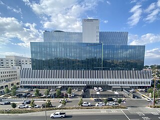
Loma Linda University Medical Center (LLUMC) is a teaching hospital in California's Inland Empire region. Opened in 1905, it is a level 1 trauma center and is staffed by nearly 900 faculty physicians and over 1,000 beds.

Forest Falls is an unincorporated community in San Bernardino County, California, 75 miles (121 km) due east of Los Angeles. The community has a population of 1,102 and contains 712 houses. Forest Falls is best known for the waterfalls on Vivian and Falls creeks and as a point of access for recreation in the San Bernardino National Forest, particularly the San Gorgonio Wilderness Area, which lies directly north of the community.
Citrus Plaza, along with the adjacent and contiguous Mountain Grove shopping center located in Redlands, California, United States, are owned by Majestic Realty Co. It consists of 520,000 square feet of retail and restaurant space, anchored by Target, Kohl’s, Barnes & Noble at Citrus Plaza and Nordstrom, Hobby Lobby, Ulta and Nike at Mountain Grove. The entire shopping center sit on 53 acres of a 120-acre master planned super block. Citrus Plaza opened in 2004-05. and Mountain Grove opened in 2015.

San Timoteo Creek is a stream in Riverside and San Bernardino counties in southern California, United States. A tributary of the Santa Ana River, it flows through San Timoteo Canyon. San Timoteo Creek has a drainage basin of about 125 square miles (320 km2). The creek receives most of its water from headwater tributaries flowing from the San Bernardino Mountains near Cherry Valley, as well as Yucaipa Creek, which flows from Live Oak Canyon.

Reche Canyon is a canyon in the far northwestern foothills of the San Jacinto Mountains, northwest of The Badlands in the Inland Empire region of Southern California. The Tongva village of Homhoangna, from which the canyon's alternative names derives, was located here. The county line between San Bernardino County and Riverside County is at the approximate midway point of the canyon; the San Bernardino half to the north is mostly within the boundaries of Colton, with a small area in Loma Linda, while the southern half is unincorporated territory of Riverside County. Reche Canyon Elementary School is located in the northern part of the canyon.
Streetcars in Redlands transported people across the city and region from 1889 until 1936. The city's network of street railways peaked around 1908 before the patchwork of separate companies was consolidated under the Pacific Electric.


