Burnie, Tasmania

Last updated

Burnie
Tasmania
Burnie-20120203-002.jpg
A view of Burnie CBD and port
Relief Map of Tasmania.png
Red pog.svg
Burnie
Coordinates 41°03′49″S145°52′31″E / 41.06361°S 145.87528°E / -41.06361; 145.87528 Coordinates: 41°03′49″S145°52′31″E / 41.06361°S 145.87528°E / -41.06361; 145.87528
Population27,174 (2018) [1]
Postcode(s) 7320
Elevation19 m (62 ft)
Time zone AEST (UTC+10)
 • Summer (DST) AEDT (UTC+11)
Location
LGA(s) City of Burnie
State electorate(s) Braddon
Federal division(s) Braddon
Mean max tempMean min tempAnnual rainfall
16.9 °C
62 °F
9.3 °C
49 °F
960.8 mm
37.8 in

Burnie is a port city on the north-west coast of Tasmania, Australia. When founded in 1827, it was named Emu Bay, being renamed after William Burnie, a director of the Van Diemen's Land Company, in the early 1840s.

Contents

As of 2019, Burnie had an urban population of 19,550. [2] Burnie is governed by the City of Burnie local government area.

Economy

The key industries are heavy manufacturing, forestry and farming. The Burnie port along with the forestry industry provides the main source of revenue for the city. [3] [4] Burnie was the main port for the west coast mines after the opening of the Emu Bay Railway in 1897. Most industry in Burnie was based around the railway and the port that served it.

After the handover of the Surrey Hills and Hampshire Hills lots, the agriculture industry was largely replaced by forestry. The influence of forestry had a major role on Burnie's development in the 1900s with the founding of the pulp and paper mill by Associated Pulp and Paper Mills in 1938 [5] and the woodchip terminal in the later part of the century. The Burnie Paper Mill closed in 2010 after failing to secure a buyer. [6]

Population

As at June 2018 Burnie, together with nearby Wynyard had an estimated urban population of 27,174 [1] , having reduced slightly at an average annual rate of -0.27% year-on-year over the preceding five years. [1]

Facilities and education

Tasmania's third largest hospital, The North West Regional Hospital is on Brickport Road. It provides both in and outpatient services for general medicine, general surgery, orthopaedics, psychiatry, and paediatrics.

Other amenities include the multi-function "Burnie Arts and Function Centre" (formerly known as the Civic Centre), post office, police station, Supreme Court, public and private hospital, as well as numerous sporting and social organisations.

Burnie is also home to the Cradle Coast campus of the University of Tasmania, and campuses of the Tasmanian Polytechnic and the Tasmanian Academy. The University of Tasmania campus includes the Cuthbertson Research Laboratories run by the Tasmanian Institute of Agricultural Research.

Retail

Burnie has a central business district with several national retailers such as Target, Kmart, The Reject Shop, Best & Less and Cotton On. Just outside the CBD there are other major retailers including Harvey Norman, Bunnings Warehouse, Spotlight, Godfreys and SuperCheap Auto.

Supermarkets in Burnie include Coles, Woolworths and IGA.

Transport

Burnie Airport is located in the adjacent town of Wynyard, a 20-minute drive from the City of Burnie.

Burnie Port is Tasmania's largest general cargo port [7] and was once Australia's fifth largest container port. It is the nearest Tasmanian port to Melbourne and the Australian mainland. As with other ports in Tasmania, it is operated by the government owned TasPorts. [8]

The port currently operates as a container port with a separate terminal for the exportation of woodchips. The port was planned to be expanded in 2013 so that it could accommodate extra freight from the proposed north-west mines in the Tarkine. [9]

Burnie was the terminus of the former Emu Bay Railway company operations. The railway line is now known as the Melba Line.

Burnie is connected with Devonport via the four lane Bass Highway and a rail link which is used for freight purposes. Burnie is also connected to the west coast of Tasmania by the Murchison Highway.

Bus service Metro Tasmania provides transport around the city and its suburbs., [10] Redline coaches used to service the North-West through to Hobart, but ceased this service in January 2021.

Coastal pathway

The development of a coastal pathway will connect Burnie and Wynyard to Latrobe as part of a State Government and Local Government Council initiative to upgrade infrastructure on the north-west coast of Tasmania. [11]

Suburbs

The city of Burnie consists of a number of small suburbs including Parklands, Park Grove, Shorewell Park, Acton, Montello, Hillcrest, Terrylands, Upper Burnie, Romaine, Havenview, Emu Heights, South Burnie and Wivenhoe.

Climate

Burnie has a borderline oceanic climate and mediterranean climate with mild summers and cool winters. The average temperature in summer ranges from 12 to 21 °C with drier days as warm as 30 °C, with around 16 hours of sunlight per day. In winter, temperature ranges from 6 to 13 °C, and only 8 hours of sunlight. Relative humidity averages over 60% for the year in the afternoon.[ citation needed ]

Burnie averages 994 mm of rainfall per year. Most of the rain is during the cooler months from May to October. The summer months bring constant daily sunshine and only occasional rainfall with temperatures up to 30 °C on the warmest and driest days. Nearly every day from January to March has a maximum temperature of 20–25 °C.

Climate data for Round Hill, Burnie (1981–2018 data)
MonthJanFebMarAprMayJunJulAugSepOctNovDecYear
Record high °C (°F)33.8
(92.8)
30.8
(87.4)
28.9
(84.0)
26.2
(79.2)
20.6
(69.1)
18.8
(65.8)
18.3
(64.9)
18.9
(66.0)
22.4
(72.3)
23.7
(74.7)
31.5
(88.7)
31.2
(88.2)
33.8
(92.8)
Average high °C (°F)21.2
(70.2)
21.5
(70.7)
20.3
(68.5)
18.0
(64.4)
15.6
(60.1)
13.7
(56.7)
13.0
(55.4)
13.4
(56.1)
14.6
(58.3)
16.1
(61.0)
18.1
(64.6)
19.6
(67.3)
17.1
(62.8)
Average low °C (°F)13.3
(55.9)
13.8
(56.8)
12.5
(54.5)
10.8
(51.4)
9.1
(48.4)
7.3
(45.1)
6.6
(43.9)
6.7
(44.1)
7.4
(45.3)
8.5
(47.3)
10.3
(50.5)
11.7
(53.1)
9.8
(49.6)
Record low °C (°F)5.2
(41.4)
5.8
(42.4)
3.6
(38.5)
3.0
(37.4)
1.8
(35.2)
0.2
(32.4)
−1.0
(30.2)
0.2
(32.4)
0.4
(32.7)
1.6
(34.9)
2.7
(36.9)
3.1
(37.6)
−1.0
(30.2)
Average precipitation mm (inches)43.0
(1.69)
33.9
(1.33)
42.7
(1.68)
67.7
(2.67)
80.3
(3.16)
97.0
(3.82)
104.5
(4.11)
104.0
(4.09)
92.5
(3.64)
74.0
(2.91)
63.0
(2.48)
62.1
(2.44)
865.5
(34.07)
Average rainy days (≥ 0.2 mm)9.97.19.011.013.815.017.117.416.514.611.910.3153.6
Mean daily sunshine hours 8.27.76.25.34.14.04.14.55.36.87.37.55.9
Source 1: Bureau of Meteorology [12] [13]
Source 2: Bureau of Meteorology (1965–1993 sunshine hours) [14]

Sport

Australian rules football is popular in Burnie. The city's team is the Burnie Dockers Football Club in the Tasmanian State League. Their ground is West Park Oval.

Rugby union is also played in Burnie. The local club is the Burnie Rugby Union Club. They are the current Tasmanian Rugby Union Statewide Division Two Premiers and were promoted to the Statewide First Division for the 2008 season.

Soccer is also represented in Burnie, with Burnie United FC having four teams compete in the northern premier league; the women's team, under 18 team, reserve team and division one team. They also have youth sides in the under 14 and under 16 competitions. Their ground is located in Montello, Tasmania.

Burnie hosts an ATP Challenger Tour tennis event, the Burnie International, during the week following the Australian Open.

Athletics events include the annual Burnie Gift and Burnie Ten.

Media

The Advocate newspaper was established in 1890 servicing the North West region. The mailroom is located in Burnie whilst the local press operations ceased in mid-2008 and were relocated to Launceston.[ citation needed ].

Burnie has access to the ABC, SBS, WIN and Southern Cross television stations as well as all new free to air television stations.

There are two commercial radio stations, 7BU at 100.9 MHz on the FM band and Sea FM on 101.7 on the FM band. Many Melbourne radio stations can be received in Burnie.[ citation needed ]

Burnie CBD and Port Panorama.jpg
Burnie CBD and Port from Wilfred Campbell Memorial Reserve

Notable people

Related Research Articles

Tasmania State of Australia

Tasmania is an island state of Australia. It is located 240 km (150 mi) to the south of the Australian mainland, separated from it by Bass Strait. The state encompasses the main island of Tasmania, the 26th-largest island in the world, and the surrounding 1000 islands. It is Australia's least populated state, with 541,965 residents as of March 2021. The state capital and largest city is Hobart, with around 40 percent of the population living in the Greater Hobart area.

Devonport, Tasmania City in Tasmania, Australia

Devonport is a city in northern Tasmania, Australia, located on the lands of the Pannilerpanner clan of the Palawa nation. It is situated at the mouth of the Mersey River. Devonport had an urban population of 23,046 at the 2016 Australian census. When counting the larger urban area, including Latrobe, the population total was 30,297 at June 2018. The area has grown at an average annual rate of 0.17% year-on-year over the preceding five years.

Rosebery is a town on the west coast of Tasmania, Australia. It is at the northern end of the West Coast Range, in the shadow of Mount Black and adjacent to the Pieman River now Lake Pieman.

Wynyard, Tasmania Town in Tasmania, Australia

Wynyard (/ˈwɪnjɚd/) wi-nyuhd) is a rural town located on the North West coast of Tasmania, Australia. Wynyard is situated 17 kilometres (11 mi) west of Burnie. As of the 2016 census, Wynyard has an estimated urban population of 5,168 and a total greater area population of 6,001. The town is a regional hub servicing the surrounding rural areas, the adjacent Burnie Wynyard Airport provides commercial flights to Melbourne and other districts. The main council offices for the Waratah-Wynyard local government area are located in Wynyard.

Zeehan Town in Tasmania, Australia

Zeehan is a town on the west coast of Tasmania, Australia 139 kilometres (86 mi) south-west of Burnie. It is located north of Strahan, Tasmania and Queenstown, Tasmania.

Somerset, Tasmania Town in Tasmania, Australia

Somerset is a small township to the west of Burnie, Tasmania, Australia, which shares its name with the County of Somerset, England, UK. Today the city of Burnie encompasses the entire Burnie-Somerset urban area; however, the town is part of the Waratah/Wynyard municipal area.

<i>The Advocate</i> (Tasmania) Newspaper in North West and Western Tasmania, Australia

The Advocate is a local newspaper of North-West and Western Tasmania, Australia. It was formerly published under the names The Wellington Times, The Emu Bay Times, and The North Western Advocate and The Emu Bay Times.

North West Football League

The North West Football League is an Australian rules football competition in North West Tasmania. The league was previously known as the "Northern Tasmanian Football League" from its inception in 1987 until the end of the 2014 season.

Australian rules football in Tasmania

Australian rules football in Tasmania known as "football" officially and locally, has a history dating back to the 1860s.

City of Burnie Local government area in Tasmania, Australia

Burnie City Council is a local government body in Tasmania, located in the city and surrounds of Burnie in the north-west of the state. The Burnie local government area is classified as urban and has a population of 19,348, which also encompasses Cooee, Hampshire, Natone and Ridgley.

Cooee, Tasmania Suburb of City of Burnie, Tasmania, Australia

Cooee is a small town on the north-west coast of Tasmania immediately west of Burnie, to which it is in effect a dormitory suburb. At the 2011 census, Cooee had a population of 559.

Hampshire is a semi-rural locality in the local government areas (LGA) of Waratah Wynyard and Burnie in the North-west and west LGA region of Tasmania. The locality is about 30 kilometres (19 mi) south-west of the town of Burnie. The 2016 census has a population of 51 for the state suburb of Hampshire.

The Darwin Football Association is an Australian rules football league in Tasmania. The clubs belonging to the association are from localities close to Burnie and on the West Coast of Tasmania. This includes Queenstown, making this competition the only competition in Australia to play some of its games on a gravel surface.

Burnie Dockers Football Club Australian football club

Burnie Dockers Football Club is an Australian rules football club in Burnie, Tasmania, Australia. The club currently competes in the North West Football League (NWFL).

Sport in Tasmania is participation in and attendance at organised sports events in the state of Tasmania in Australia.

Climate of Tasmania

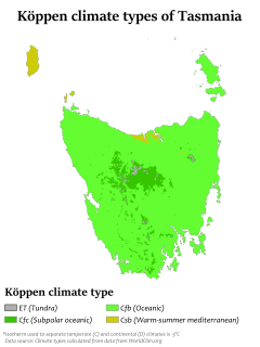
Tasmania has a cool temperate climate with four distinct seasons. The highest recorded maximum temperature in Tasmania is 42.2 °C (108.0 °F) at Scamander on 30 January 2009, during the 2009 southeastern Australia heat wave. Tasmania's lowest recorded minimum temperature is −14.2 °C (6.4 °F) on 7 August 2020, at Central Plateau.

West Park Oval

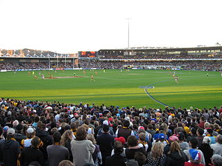
West Park Oval is an Australian Rules football, cycling and athletics venue located on the shores of Bass Strait in Burnie, Tasmania. It is the current home of the Burnie Dockers in the Tasmanian State League and previously in the NTFL and in the original TFL Statewide League.

Joe Littler Australian rules footballer

Harold Kennedy "Joe" Littler was an Australian rules footballer who played for South Melbourne in the Victorian Football League (VFL). He also had a long career in Tasmania playing in the Northern Tasmanian Football Association, North West Football Union (NWFU), and the North West Football Association (NWFA).

Victor Tasman Castles was an Australian rules footballer who played with South Melbourne in the Victorian Football League (VFL) during the 1940s.

Montello is a suburb of the city of Burnie in North West Tasmania. It is about 2 kilometres (1.2 mi) south-west of the centre of Burnie, and recorded a population of 1217 in the 2016 census.

References

  1. 1 2 3 "3218.0 – Regional Population Growth, Australia, 2017-18: Population Estimates by Significant Urban Area, 2008 to 2018". Australian Bureau of Statistics. Australian Bureau of Statistics. 27 March 2019. Retrieved 25 October 2019. Estimated resident population, 30 June 2018.
  2. "Data by region | Australian Bureau of Statistics". dbr.abs.gov.au. Retrieved 27 May 2021.
  3. Burnie Port Authority (1986), Port of Burnie, Tasmania : port information, Burnie Port Authority, ISBN   978-0-7246-1452-3
  4. "Archived copy". Archived from the original on 10 April 2013. Retrieved 7 April 2013.{{cite web}}: CS1 maint: archived copy as title (link)
  5. "Burnie Paper Mill Nearing Completion". The Advocate . Burnie, Tas.: National Library of Australia. 4 December 1937. p. 7. Retrieved 7 April 2013.
  6. "Burnie paper mill to shut", Australasian Business Intelligence, COMTEX News Network, Inc, 13 April 2010, ISSN   1320-6680
  7. "Burnie Port Information" . Retrieved 12 November 2020.
  8. Sean Ford (23 December 2013). "Single port body failed: Chamber". The Advocate. Archived from the original on 24 December 2013.
  9. "Burnie port upgrade". The West Australian. 15 February 2013. Archived from the original on 12 April 2013. Retrieved 16 March 2013.
  10. Metro Tasmania website Archived 1 May 2021 at the Wayback Machine
  11. "Council welcomes Burnie to Wynyard coastal pathway funding". www.rdatasmania.org.au. Retrieved 30 September 2021.
  12. "Climate statistics for Round Hill, Burnie". bom.gov.au. Bureau of Meteorology. Retrieved 28 October 2017.
  13. "Climate statistics for Round Hill, Burnie". bom.gov.au. Bureau of Meteorology. Archived from the original on 4 March 2016. Retrieved 16 July 2017.
  14. "Climate statistics for Elliott Research Station". bom.gov.au. Bureau of Meteorology. Archived from the original on 7 May 2018. Retrieved 16 July 2017.
  15. Ford, Sean (30 May 2019). "Elphinstone tops Tassie wealth list, two more make national cut". The Advocate. Retrieved 30 September 2021.
  16. "'I've found where I belong': Zima Anderson's life on Ramsay Street". 17 October 2019.