Mill Creek Mountain is a continuous mountain ridge that runs northeast through Hampshire and Hardy counties in the Eastern Panhandle region of the U.S. state of West Virginia. Rising to its greatest elevation of 2,650 feet (808 m) at High Knob, Mill Creek is a folded mountain ridge, belonging to the Ridge-and-Valley Appalachians. Mill Creek Mountain forms the western edge of the South Branch Potomac River Valley and is named for Mill Creek that carves through it at Mechanicsburg Gap allowing the Northwestern Turnpike to pass through as well. Along with Sawmill Ridge, Mill Creek Mountain forms the Trough along the South Branch.

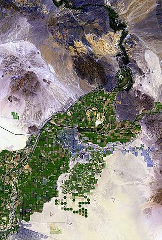
The Cargo Muchacho Mountains are located in the southeast Colorado Desert in the Lower Colorado River Valley, in Imperial County, California in the United States. Much of the range's geology was described by the geologist John T. Dillon.

Holston Mountain is a mountain ridge in Upper East Tennessee and southwest Virginia, in the United States. It is in the Blue Ridge Mountains part of the Appalachian Mountains. Holston Mountain is a very prominent ridge-type mountain in Tennessee's Ridge and Valley Region, about 28 miles (45 km) long, running from southwest to northeast, covering about 268 square miles (690 km2). Its highest summit is Holston High Point, on which a Federal Aviation Administration (FAA) aircraft navigational beacon is located, at an elevation of 4,280 feet (1,300 m) above mean sea level. The second and third highest points are Rye Patch Knob, at 4,260 feet (1,300 m) above mean sea level and Rich Knob, at 4,240 above mean sea level respectively. The fourth highest point is Holston High Knob where an old dismantled Cherokee National Forest fire tower marks the elevation at 4,136 feet (1,261 m) above mean sea level.

Waterrock Knob is a mountain peak in the U.S. state of North Carolina. It is the highest peak in the Plott Balsams and is the 16th-highest mountain in the Eastern United States.

Blue Knob is a summit in the eastern United States with a broad dome that is the northernmost 3,000-footer in the Allegheny Mountains. It is the highest point in Bedford County, Pennsylvania.

The Great Balsam Mountains, or Balsam Mountains, are in the mountain region of western North Carolina, United States. The Great Balsams are a subrange of the Blue Ridge Mountains, which in turn are a part of the Appalachian Mountains. The most famous peak in the Great Balsam range is Cold Mountain, which is the centerpiece of author Charles Frazier's bestselling novel Cold Mountain. Other notable peaks include Richland Balsam, which is the highest peak in the range, Black Balsam Knob, and Mount Pisgah.

Basin Mountain is a mountain in the Great Range of the Adirondacks in the U.S. state of New York. It is the ninth-highest peak in New York, with an elevation of 4,827 feet (1,471 m), and one of the 46 High Peaks in Adirondack Park. It is located in the town of Keene in Essex County. The peak was named either for the basins formed between knobs on its slopes or the large basin to its southeast formed by it and the surrounding mountains. The name Basin was most likely coined by Orson Schofield Phelps and Frederick W. Perkins in 1857 during an ascent of Mount Marcy. The earliest appearance of the name in writing was made by surveyor Verplanck Colvin in 1873.
Salt Pond Mountain is a mountain located in Giles County, Virginia. The mountain, which is part of the Ridge-and-valley province of the Appalachian Mountains, extends about seven miles (12 km) from southwest to northeast. The highest peak is Bald Knob, at the southeast end, south of Mountain Lake. Salt Pond Mtn. joins Johns Creek Mountain at the southwest end, and the Big Mountain – Potts Mountain ridge at the northeast end, just south of West Virginia.

Marks Knob is a mountain in the central Great Smoky Mountains, in the southeastern United States. It has an elevation of 6,169 feet (1,880 m), with 249 feet (76 m) of clean prominence. Its summit is a popular bushwhacking destination and one of the most difficult-to-reach summits of the Southern Sixers.
The Ossipee Mountains are a small mountain range in the New England state of New Hampshire, United States. The remains of an ancient volcanic ring dike, they lie north of Lake Winnipesaukee, east of Squam Lake, and south of the Sandwich Range, the southernmost of the White Mountains. 2,990 ft (910 m) Mount Shaw is their highest point.

Pilot Knob is a peak in Imperial County, California. Pilot Knob is located 8 miles (13 km) southeast of Ogilby, It rises to an elevation of 876 feet (267 m). Pilot Knob is a rocky landform, geologically a Volcanic plug, west of Yuma, Arizona–Winterhaven, California; it is connected to the Cargo Muchacho Mountains, the central portion of the mountains being about 7 miles (11 km) north. Pilot Knob was named for its prominence as a landmark for riverboat traffic in the 19th-20th centuries on the Colorado River which borders Winterhaven–Yuma. Pilot Knob is an Area of Critical Environmental Concern administered by the Bureau of Land Management.

Bald Knob is an unincorporated community in Boone County, West Virginia, United States. Bald Knob is located on West Virginia Route 85, 17 miles (27 km) southeast of Madison. Bald Knob had a post office, which closed on October 1, 2005. The community took its name from nearby Bald Knob peak.
Burnt House is an unincorporated community in Ritchie County, West Virginia, United States. Burnt House is located on West Virginia Route 47 and Grass Run, 11.8 miles (19.0 km) south-southeast of Harrisville. The Burnt House Post Office closed 5/23/1986.
Haynes Mountain is a mountain located in the Catskill Mountains of New York south-southwest of Pine Hill. Haynes Mountain is located south of Belle Ayr Mountain, south-southeast of Hirams Knob, and north of Eagle Mountain.
Steenburg Mountain is a mountain located in the Catskill Mountains of New York north-northwest of Windham. High Knob is located northwest, Sicklers Mountain is located west-southwest, South Mountain is located south, and Mount Pisgah is located southeast of Steenburg Mountain.
Acra Point is a mountain in Greene County, New York. It is located in the Catskill Mountains south of South Durham. Burnt Knob is located west-northwest, and Blackhead is located south of Acra Point.
The Knob is a mountain in Greene County, New York. It is located in the Catskill Mountains north-northeast of Ashland. Ashland Pinnacle is located north, and Huntersfield Mountain is located northwest of The Knob. The mountain has an elevation of 2,638 feet.

Pilot Knob is a 12,245-foot-elevation (3,732 meter) mountain summit located in Fresno County in the Sierra Nevada mountain range in northern California, United States. It is situated at the intersection of Piute Canyon and French Canyon, in the John Muir Wilderness, on land managed by Sierra National Forest. It is set 2.5 miles (4.0 km) south of Merriam Peak and three miles north of the Matthes Glaciers. Pilot Knob is the 360th-highest peak in California, and topographic relief is significant as the west aspect rises 2,800 feet above Hutchinson Meadow in approximately one mile. This mountain was likely named by the USGS during the 1907–09 survey for the Mt. Goddard Quadrangle, and the toponym has been officially adopted by the U.S. Board on Geographic Names.

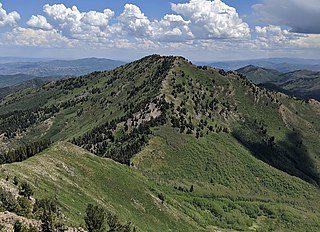
Gobblers Knob is a 10,246-foot elevation (3,123 m) mountain summit located in Salt Lake County, Utah, United States.


