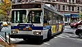
Bx15 and M125 buses

Last updated

bx15, m125
bx15
Third Avenue/125th Street Line [1]
LFSA 5441 on the Bx15.jpg
Overview
System MTA Regional Bus Operations
Operator New York City Transit Authority (NYCT)
Garage Kingsbridge Depot
Formerly West Farms Depot [2] (Bx15)
Tuskegee Airmen Depot (M125)
Vehicle
Began service1864 (streetcar line)
April 1, 1916 (Bronx-Harlem streetcar)
August 5, 1941 (Previously Bx29, and present Bx15 bus service) [3]
June 26, 2022 (M125 bus service)
Route
Locale The Bronx and Manhattan, New York, U.S.
Communities served Fordham, Belmont, Tremont, Morrisania, Melrose, Mott Haven (Bx15)
Mott Haven, East Harlem, Harlem, Manhattanville (M125)
Start Fordham Plaza, Bronx  Fordham Road (Bx15)
The Hub, Bronx  149th Street (M125)
Via Third Avenue [4] (Bx15), 125th Street (M125)
End The Hub, Bronx  149th Street (Bx15)
Manhattanville, Manhattan  – 12th Avenue (M125)
Length4.0 miles (6.4 km) (Bx15)
2.6 miles (4.2 km) (M125)
Other routes Bx41 Webster Av
M60 SBS 125th St/Astoria Bl/LaGuardia Airport
M100 B'way/Amsterdam Av
M101 3rd/Lexington Avs/125th St/Amsterdam Av
Service
Operates24 hours
Annual patronage2,276,211 (Bx15, 2022) [5]
855,646 (M125, 2022)
Timetable Bx15 M125
  Bx13
M116
 {{{system_nav}}}  Bx16
Q1 (Queens) 

The Bx15 and M125 bus routes constitute the Third Avenue/125th Street Line, a public transit line in New York City. The Bx15 runs between Fordham Plaza and the Hub in the Bronx, running primarily along Third Avenue. The M125 runs between the Hub in the Bronx and Manhattanville in Manhattan, running along Willis Avenue in the South Bronx and along 125th Street in Harlem, Manhattan.

Prior to 2022, the corridor was a single bus route, the Bx15. The route is the successor to a streetcar line of the Union Railway Company and later the Third Avenue Railway known as the Willis Avenue Line or Willis Avenue−125th Street Line. The streetcar line, the first street railway in the Bronx, was known as the Harlem Bridge, Morrisania, and Fordham Railroad. The route began operation on Third Avenue in the Bronx in 1864, and the company was incorporated as the Union Railway Company in 1892. The Union Railroad applied in 1904 for extensions of several streetcar lines into Manhattan, including an extension of the Willis Avenue Line across 125th Street. The Willis Avenue Line was ultimately extended in 1916 across the 125th Street Crosstown Line.

The streetcar line was replaced by bus service in 1941; the route was known as the Bx29 prior to 1984. From 1973 to 2013 the Bx15 shared Third Avenue with the Bx55, a limited-stop service which replaced rapid transit service on the Third Avenue Elevated line between the Hub and Williamsbridge. In 2013, the Bx55 was converted into the Bx15 Limited, extending the route south to Manhattan, but eliminating service north of Fordham Plaza. The Bx15 south of the Hub was expected to be split into a new M125 bus route in 2020, but was delayed due to the COVID-19 pandemic in New York City; the split took place on June 26, 2022.

Route description and service

A 2010-model Nova Bus LFS articulated on the Bx15 traveling on 125th Street towards West Harlem in 2020 2010 Nova Bus LFS 1207 on the Bx15 at 125 St and Park Ave.jpg
A 2010-model Nova Bus LFS articulated on the Bx15 traveling on 125th Street towards West Harlem in 2020

The current Bx15 bus route begins at Fordham Road and Third Avenue in today's Fordham Plaza. It runs south down Third Avenue to Third Avenue–149th Street station in the Hub, where it terminates. [6] The Bx15 connects the two largest shopping districts in the Bronx: Fordham Road and the Hub. [7]

The M125 bus route begins at the Hub, traveling south on Willis Avenue. At 138th Street, southbound buses turn west and travel on the Third Avenue Bridge into Manhattan, while northbound buses use the Willis Avenue Bridge from Manhattan. After crossing the bridge into Harlem, the M125 turns west along 125th Street, sharing the 125th Street Crosstown Line with several other bus routes. It terminates at the west shore of Manhattan, on 12th Avenue. [4] [6] [8] In Manhattan, the M125 shares the 125th Street Crosstown corridor with two other bus routes: the M101 local bus and the M60 Select Bus Service route to LaGuardia Airport [8]

On weekdays except early mornings and nights, the Bx15 Limited operates the entire route between 149th Street and Fordham Plaza, making limited stops. The Bx15 local runs between 149th Street and Fordham Plaza at all times. [4] [7] Local and limited buses typically run every 8 to 12 minutes all day, except during late nights, when local buses run every hour and limited service does not run. [9] The M125 also runs every 8 to 12 minutes all day, except during late nights when buses run every hour. The M125 makes all local stops. [10]

The Bx15 fleet is maintained from the Kingsbridge Depot. [2] The route exclusively uses articulated buses, namely Nova Bus LFS articulated models. [11] During weekday peak hours, Nova Bus LFS 40 foot (12 m) long buses run on the route to fill in for articulated models.

Ridership

In 2018, the latest year for which passenger numbers are available, the Bx15 and Bx15 Limited had a combined 7,004,278 passengers, [5] or an average of 21,777 per weekday. [12]

History

As a streetcar line

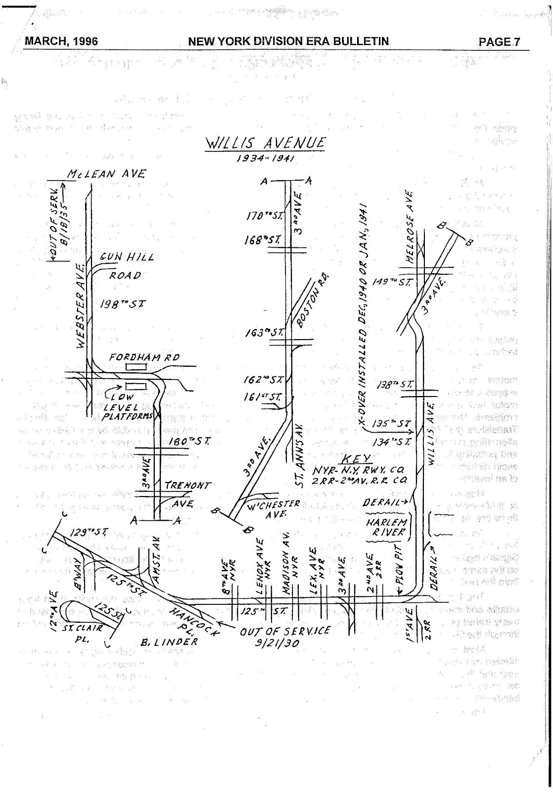
In 1863, the first street railway was constructed in the Bronx, known as the Harlem Bridge, Morrisania, and Fordham Railroad. The route ran from the Harlem Bridge (now Third Avenue Bridge) to Fordham via Third Avenue, and began operation in 1864. It was informally called the "Huckleberry Road". [13] In 1892, the company was incorporated as the Union Railway Company. On August 23 of that year, it was granted several streetcar franchises in the Bronx by the Board of Aldermen, as part of an expanded "Huckleberry System". This included a line from the Harlem River to the Westchester County border via Willis Avenue, Melrose Avenue, Webster Avenue, and Bronx River Road. [13] [14] [15] The line was completed by fall 1895. [14] The company would become a subsidiary of the Third Avenue Railway in 1898. [13]

In February 1904, the Union Railroad would apply for extensions of several streetcar lines into Manhattan. This included an extension of the Willis Avenue Line from 134th Street in Mott Haven over the recently constructed Willis Avenue Bridge (opened in 1901) [13] into East Harlem at 125th Street, connecting with lines of the Third Avenue Railway. [16] Ten years later on July 2, 1914, the company received a permit to extend Willis Avenue service across the bridge, then west along 125th Street to Fort Lee Ferry, which connected Manhattan with Fort Lee, New Jersey. The service was requested to eliminate the required transfer to other streetcar lines. [17] The new service was inaugurated on April 1, 1916, providing a link between the Bronx and New Jersey. The occasion was celebrated with a 7-day carnival in Harlem. [18] [19] Thereafter, the line became alternately known as the Willis Avenue−125th Street Line. [20]

In its final iteration, the line traveled between Fordham and western Harlem using Third Avenue, the Willis Avenue Bridge, and 125th Street. The line terminated at a loop at 12th Avenue (Riverside Drive) between 125th Street and Saint Clair Place (geographically 129th Street). At 12th Avenue there was a connection to the Fort Lee Ferry. [21] [22] [16] The line formerly proceeded further north along Webster Avenue to McClean Avenue, at the border with the city of Yonkers in Westchester County. This portion of the line was discontinued on August 18, 1935. [22] Between 149th Street and Gun Hill Road, the line ran directly underneath the Third Avenue Elevated line, a rapid transit line which formerly ran to Lower Manhattan. [16] The route between Fordham Plaza and the city line along Webster Avenue was also shared with the Webster and White Plains Avenues Line streetcars. [22] [16]

As a bus line

20th century

A Bx55 bus running underneath the former 174th Street El station in 1974 172ND ST., GENERAL VIEW TO THE WEST. - Interborough Rapid Transit Company, Third Avenue Elevated Line, Borough of the Bronx, New York, New York County, NY HAER NY,3-BRONX,13-42.tif
A Bx55 bus running underneath the former 174th Street El station in 1974

Beginning in the 1920s, many streetcar lines in the Bronx, Manhattan and the rest of the city began to be replaced by buses, particularly after the unification of the city's three primary transit companies in June 1940. [20] [23] [24] The conversion of the Willis Avenue Line occurred in 1941, as part of the conversion of the Third Avenue Bridge and Willis Avenue Bridge into one-way spans between the Bronx and Manhattan. The new traffic pattern was instituted on the morning of August 5, 1941, and bus service along the former streetcar route began that afternoon. [25] [26] The bus route would be numbered 29, later the "Bx29". [20] [27] [28] The bus route was operated by the Third Avenue Railway company until 1956, and by the New York City Omnibus Corporation (later under the brand Fifth Avenue Coach Lines) until 1962. That year, the New York City Transit Authority began operating the line under the subsidiary Manhattan and Bronx Surface Transit Operating Authority (MaBSTOA), which continues to operate the route under the Metropolitan Transportation Authority (MTA). [29]

On April 29, 1973, service on the IRT Third Avenue Line (by that time truncated to the Bronx) was eliminated and replaced by the Bx55 limited bus service, which provided free transfers to the subway at Third Avenue–149th Street and 161st Street–Yankee Stadium. [30] [31] [32] On February 19, 1984, the Bronx bus system was redesigned, and southbound Bx55 service was rerouted off of Washington Avenue between 189th Street and 163rd Street and onto Third Avenue. [32] [33] In addition, several bus routes were redesigned, with higher-priority routes given lower numbers. As part of the 1984 changes, the Bx29 was renumbered to the Bx15. [34] [35] Since the Bx55 already offered free transfers to the subway, it was one of the few routes in the city to allow free transfers to the subway prior to the introduction of the MetroCard in 1993, and one of the first routes to use the MetroCard. [36] [37] Paper tickets were used prior to the use of MetroCard for free transfers at Third Avenue–149th Street and 161st Street—Yankee Stadium. [38]

In June 1995, service along the Bx55 branch to Yankee Stadium via East 161st Street, stopping only at Washington Avenue and River Avenue, was discontinued to improve service for riders and reliability. While only 5% of riders used this branch, it received 21% of service on weekdays and 25% of service on weekends. Bx6 service was increased to mitigate the need to transfer to get to Yankee Stadium. In addition, free transfers were allowed between the Bx55 and intersecting bus routes, changing the route from a rapid transit replacement to a limited-stop branch of the Bx15. In 1995, New York City Transit was in the process of building a weather-protected intermodal terminal at Third Avenue–149th Street. [38] On September 10, 1995, as part of systemwide cuts in bus and subway service to reduce the MTA's budget deficit, late night Bx55 service north of Fordham Plaza was discontinued. [39] [40]

On September 8, 1996, [41] late night Bx55 service, between 1 a.m. and 4:30 a.m., was eliminated and merged with the Bx15. The frequency of Bx15 service along the entire route was reduced from running every 50 minutes to running every 60 minutes. Supplemental Bx15 service was provided between Fordham Road and 149th Street to maintain the Bx55's frequency. To maintain the transfer to the subway, bus-subway transfers were accepted on the Bx15 overnight. The change was made to eliminate duplicative service, which was lightly patronized. In addition, an unnecessary turn at 147th Street was eliminated; it had existed because a support pillar of the Third AvenueI Elevated, which had been demolished for some time, had prevented northbound buses from turning directly from Willis Avenue to Third Avenue. [42]

In December 1999, the MTA announced a plan to make a slight route change in southbound Bx15 service between East 138th Street and the Third Avenue Bridge. At the time, buses ran west on East 138th Street, south on Third Avenue, and south across the Third Avenue Branch. Buses had to cross multiple lanes of moving traffic to get into the leftmost lane so they could exit at East 128th Street in Manhattan. The change would have buses continue to turn left onto Third Avenue, but would reroute buses to turn left at a traffic island, south on Lincoln Avenue, west on East 133rd Street, and south directly onto the leftmost lane of the Third Avenue Bridge, eliminating a weaving maneuver. Two bus stops were added along Lincoln Avenue at East 136th Street and East 133rd Street to provide improved service in the area. The change was planned to take effect in January 2000. [43]

21st century

A non-articulated Bx15 entering the Third Avenue Bridge towards upper Manhattan. This was taken in 2007, before the Bx15's transfer from West Farms Depot to Kingsbridge Depot. Portmorris1.JPG
A non-articulated Bx15 entering the Third Avenue Bridge towards upper Manhattan. This was taken in 2007, before the Bx15's transfer from West Farms Depot to Kingsbridge Depot.

In June 2002, as part of an outside study, the Third Avenue corridor was identified for the implementation of bus rapid transit service, due to heavy ridership and slow travel speeds on the corridor. [44] In February 2004, selected weekday and all weekend Bx55 trips terminated at Fordham Plaza. [45] [46] On June 27, 2010, evening and weekend Bx55 service was eliminated. [46]

In 2009, as part of Phase II of the MTA and New York City Department of Transportation (DOT)'s Select Bus Service (SBS), both the Third Avenue and Webster Avenue bus corridors were studied for the implementation of a north-to-south bus rapid transit service through the South Bronx. [47] [48] The Bx41 Limited along Webster Avenue was selected for conversion to SBS since that corridor was wider, [49] and became the Bx41 SBS on June 30, 2013. [7] [48] On the same day, the Bx55 was discontinued and, on July 1, it was replaced by new Bx15 limited-stop service, which operated at all times except late nights and weekends. Service along 125th Street was replaced by Bx15 limited service, and by Bx15 local service when limited service did not run. Service north of Fordham Plaza along Webster Avenue was replaced by the Bx41 SBS. [45] [48] [50] The service changes coincided with the reconstruction of Fordham Plaza's terminal area beginning in 2013, closing Third Avenue to all non-bus through traffic and constructing a bus loop to "turn" terminating Bx15 buses. [51] [52] The bus loop was completed in 2014. [53]

As part of the MTA's 2017 Fast Forward Plan to speed up mass transit service, a draft plan for a reorganization of Bronx bus routes was proposed in draft format in June 2019, with a final version published in October 2019. The plan included splitting the section of the Bx15 south of the Hub into a new bus route labeled the M125. [54] This change was proposed to be implemented by mid-2020. [55] [56] Due to the COVID-19 pandemic in New York City, the changes were halted for over a year. [57] A final implementation date was announced in February 2022, [58] and the redesign took effect on June 26, 2022. [59] [60] With the change, an additional free transfer was provided to allow Bx15 riders to continue to transfer to the subway for free along 125th Street, though now with a middle leg on the M125. [61]

See also

Related Research Articles

<span class="mw-page-title-main">6 (New York City Subway service)</span> New York City Subway service

The 6 Lexington Avenue Local and <6> Pelham Bay Park Express are two rapid transit services in the A Division of the New York City Subway. Their route emblems, or "bullets", are colored forest green since they use the IRT Lexington Avenue Line in Manhattan. Local service is denoted by a (6) in a circular bullet, and express service is denoted by a <6> in a diamond-shaped bullet. On the R62A rolling stock, this is often indicated by LEDs around the service logo to indicate local or express service to riders. The LEDs illuminate in a green circle pattern for 6 local trains and in a red diamond pattern for <6> trains.

<span class="mw-page-title-main">Fordham station</span> Metro-North Railroad station in the Bronx, New York

Fordham station, also known as Fordham–East 190th Street station, is a commuter rail stop on the Metro-North Railroad's Harlem and New Haven Lines, serving Fordham Plaza in the Fordham neighborhood of the Bronx, New York City. The platforms are situated just below street level and feature two expanded side platforms that serve eight cars each, on the outer tracks. The station building sits above the tracks on the Fordham Road overpass, and still bears the name New York Central Railroad on its facade. The station is among the busiest rail stations in the Bronx.

<span class="mw-page-title-main">IRT Third Avenue Line</span> Former New York City rapid transit line

The IRT Third Avenue Line, commonly known as the Third Avenue Elevated, Third Avenue El, or Bronx El, was an elevated railway in Manhattan and the Bronx, New York City. Originally operated by the New York Elevated Railway, an independent railway company, it was acquired by the Interborough Rapid Transit Company (IRT) and eventually became part of the New York City Subway system.

<span class="mw-page-title-main">Third Avenue</span> North-south avenue in Manhattan and the Bronx, New York

Third Avenue is a north-south thoroughfare on the East Side of the New York City borough of Manhattan, as well as in the center portion of the Bronx. Its southern end is at Astor Place and St. Mark's Place. It transitions into Cooper Square, and further south, the Bowery, Chatham Square, and Park Row. The Manhattan side ends at East 128th Street. Third Avenue is two-way from Cooper Square to 24th Street, but carries only northbound (uptown) traffic while in Manhattan above 24th Street; in the Bronx, it is again two-way. However, the Third Avenue Bridge carries vehicular traffic in the opposite direction, allowing only southbound vehicular traffic, rendering the avenue essentially non-continuous to motor vehicles between the boroughs.

<span class="mw-page-title-main">M15 (New York City bus)</span> Bus route in Manhattan, New York

The First and Second Avenues Line, also known as the Second Avenue Line, is a bus line in Manhattan, New York City, running mostly along Second Avenue from Lower Manhattan to East Harlem. Originally a streetcar line along Second Avenue, it is now the M15 bus route, the busiest bus route in the city and United States, carrying over 9.6 million people annually. MTA Regional Bus Operations, under the New York City Bus and Select Bus Service brands, operates the local out of the Tuskegee Airmen Bus Depot and the SBS from the Mother Clara Hale Bus Depot. Service is operated exclusively with articulated buses.

<span class="mw-page-title-main">Third and Lexington Avenues Line</span> Bus routes in Manhattan, New York

The Third and Lexington Avenues Line, also known as the Third Avenue Line, is a public transit line in Manhattan, New York City, running from Lower Manhattan to Fort George in Washington Heights. Originally a streetcar line, it now consists of the M98, M101, M102, and M103 bus routes, operated by the New York City Transit Authority. The M98 bus route operates on Third Avenue between East 65th Street and East 127th Street, although it previously continued to 32nd Street. The M101, M102 and M103 bus routes run southbound on Lexington Avenue north of East 24th Street.

<span class="mw-page-title-main">M60 (New York City bus)</span> Bus route in Manhattan and Queens, New York

The M60 Select Bus Service is a bus route in New York City. It is part of MTA Regional Bus Operations, operated by the Manhattan and Bronx Surface Transit Operating Authority (MaBSTOA) under the New York City Transit brand. The M60 provides service between the Upper West Side of Manhattan and LaGuardia Airport in East Elmhurst, Queens, traveling between boroughs via the RFK-Triborough Bridge. It is the only direct public transit option between Manhattan and LaGuardia Airport.

<span class="mw-page-title-main">Bx41 (New York City bus)</span> Bus route in the Bronx and Manhattan

The Bx41 is a public transit line in New York City. It runs within the borough of the Bronx, operating along Melrose and Webster Avenue.

<span class="mw-page-title-main">Bx1 and Bx2 buses</span> Bus routes in the Bronx, New York

The Bx1 and Bx2 are two bus routes that run on the Grand Concourse in the Bronx, New York City. The routes, which are operated by the MTA Regional Bus Operations, also follow Sedgwick Avenue and Mosholu Parkway for a short distance at their northern end. As the numbers suggest, these were the first two bus routes in the Bronx.

<span class="mw-page-title-main">The Hub, Bronx</span> Commercial center in Bronx, New York, US

The Hub is a major commercial center for the South Bronx, New York. It is located where four roads converge: East 149th Street, and Willis, Melrose and Third Avenues. It is primarily located inside the neighborhood of Melrose but also lines the northern border of Mott Haven.

<span class="mw-page-title-main">Bx12 bus</span> Bus route in New York City

The Bx12 is a public transit line in New York City running along the 207th Street Crosstown Line, within the boroughs of Manhattan and the Bronx. The line runs along 207th Street in Upper Manhattan and along the continuous Fordham Road and Pelham Parkway in the Bronx.

<span class="mw-page-title-main">Select Bus Service</span> Bus service in New York City

Select Bus Service is a brand used by the Metropolitan Transportation Authority (MTA)'s Regional Bus Operations for limited-stop bus routes with some bus rapid transit features in New York City. The first SBS route was implemented in 2008 to improve speed and reliability on long, busy corridors.

The 129th Street station was a transfer station on the IRT Third Avenue Line in Manhattan, New York City, shared by elevated trains of both the Third Avenue Line and IRT Second Avenue Line. The next stop to the north was 133rd Street for the main line and Willis Avenue for the Willis Avenue spur, both of which were across a swing bridge above the Harlem River in the Bronx. The next stop to the south was 125th Street−Third Avenue for Third Avenue Line trains and 125th Street−Second Avenue for Second Avenue Line trains.

<span class="mw-page-title-main">149th Street station (IRT Third Avenue Line)</span> New York City Subway station in The Bronx (closed 1973)

The 149th Street station was a station on the demolished IRT Third Avenue Line in the Bronx, New York City. It was located in "The Hub" in the South Bronx, at the intersection of 149th Street, Third Avenue, Willis Avenue, and Melrose Avenue. Opened as an express station in 1887 and later operating as the line's southern terminus, the station closed in 1973 and was demolished by 1977 due to political pressure in the area.

<span class="mw-page-title-main">Fordham Road–190th Street station</span> New York City Subway station in Bronx (Closed 1973)

The Fordham Road–190th Street station was an express station on the demolished IRT Third Avenue Line in the Bronx, New York City. It was located at Fordham Road and Third Avenue, one block east of Webster Avenue, in the modern location of Fordham Plaza. Opened in 1901, the station was closed in 1973 and demolished in 1977 along with the rest of the Third Avenue Line. No trace of the station exists today.

<span class="mw-page-title-main">Bus lanes in New York City</span> Bus priority system

Since 1963, New York City has been using a system of bus lanes that are intended to give priority to buses, which contain more occupants than passenger and commercial vehicles. Most of these lanes are restricted to buses only at certain days and times, but some bus lanes are restricted 24/7. As of May 2021, there are 138.4 miles (222.7 km) of bus lanes within New York City.

<span class="mw-page-title-main">Bx28 and Bx38 buses</span> Bus routes in the Bronx, New York

The Bx28 and Bx38 constitute a public transit line in The Bronx. These routes primarily run on Gun Hill Road between the northern part of West Bronx and Co-op City.

<span class="mw-page-title-main">Bx7, Bx20, and M100 buses</span> Bus routes in Manhattan and The Bronx, New York

The Broadway-Kingsbridge Line is a public transit line in Manhattan, running primarily along Broadway in Upper Manhattan. Originally a streetcar line, it is now the Bx7, Bx20 and M100 bus routes, all operated by the MTA Regional Bus Operations under the New York City Transit Authority brand.

References

  1. "Bronx Bus Map Notes". mta.info. Metropolitan Transportation Authority. October 2018. Archived from the original on January 7, 2020. Retrieved March 19, 2020.
  2. 1 2 Newman, Andy (December 23, 2005). "The Slow, Ponderous Process of Restarting the Wheels". The New York Times. ISSN   0362-4331. Archived from the original on February 19, 2020. Retrieved February 19, 2020.
  3. Bill Twomey (May 28, 2002). South Bronx. Arcadia Publishing. ISBN   978-1-4396-2839-3. Archived from the original on April 18, 2022. Retrieved October 26, 2016.
  4. 1 2 3 MTA Regional Bus Operations. "Bx15 bus schedule".
  5. 1 2 "Facts and Figures". mta.info. August 28, 2011. Archived from the original on September 24, 2017. Retrieved June 19, 2016.
  6. 1 2 "Bronx Bus Map" (PDF). Metropolitan Transportation Authority. October 2018. Retrieved December 1, 2020.
  7. 1 2 3 "+selectbusservice: Bx41 on Webster Avenue Progress Report" (PDF). Metropolitan Transportation Authority, New York City Department of Transportation. August 25, 2014. Archived (PDF) from the original on June 27, 2015. Retrieved December 24, 2015.
  8. 1 2 "Manhattan Bus Map" (PDF). Metropolitan Transportation Authority. July 2019. Retrieved December 1, 2020.
  9. "Bronx Bus Service" (PDF). Metropolitan Transportation Authority. October 2018. Retrieved December 1, 2020.
  10. "Manhattan Bus Service" (PDF). Metropolitan Transportation Authority. July 2019. Retrieved December 1, 2020.
  11. "New York MTA Bus Roster (Depot) – The Insider's Guide". transiTALK Transportation Media Group. November 20, 2019. Archived from the original on December 15, 2019. Retrieved February 29, 2020.
  12. "Facts and Figures". mta.info. August 28, 2011. Archived from the original on July 7, 2013. Retrieved June 19, 2016.
  13. 1 2 3 4 S. Jenkins. The Story of the Bronx from the Purchase Made by the Dutch from the Indians in 1639 to the Present Day. Рипол Классик. pp. 238–241. ISBN   978-1-143-80870-8. Archived from the original on December 24, 2016. Retrieved October 26, 2016.
  14. 1 2 "Union Railway Hearing: Question of Revoking Its Charter Before the Alderman" (PDF). The New York Times. November 2, 1895. ISSN   0362-4331. Archived (PDF) from the original on June 27, 2022. Retrieved December 24, 2015.
  15. "Gift to the Huckleberry: Valuable Franchises Voted by the Alderman" (PDF). The New York Times. August 24, 1892. ISSN   0362-4331. Archived (PDF) from the original on June 27, 2022. Retrieved December 24, 2015.
  16. 1 2 3 4 "Union Railway Plans To Enter Manhattan: Petitions for Franchises to Effect Thirteen Connections" (PDF). The New York Times. February 24, 1904. ISSN   0362-4331. Archived (PDF) from the original on January 21, 2022. Retrieved December 24, 2015.
  17. "Admit Bronx Trolley Line: Cars May Run to Fort Le Ferry Without Giving Transfers" (PDF). The New York Times. July 3, 1914. ISSN   0362-4331. Archived (PDF) from the original on June 27, 2022. Retrieved December 24, 2015.
  18. New York State Public Service Commission (1917). Report of the Public Service Commission For The First District of The State of New York For the Year Ending December 31, 1916. p. 351. Archived from the original on June 27, 2022. Retrieved October 26, 2016.
  19. "7-Day Carnival Starts In Harlem: Will Celebrate the Union of the Bronx and Jersey by Trolley and Ferry" (PDF). The New York Times. April 2, 1916. ISSN   0362-4331. Archived (PDF) from the original on June 27, 2022. Retrieved December 24, 2015.
  20. 1 2 3 Sparberg, Andrew J. (October 1, 2014). From a Nickel to a Token: The Journey from Board of Transportation to MTA. Fordham University Press. ISBN   978-0-8232-6190-1.
  21. New York Legislature (1920). Report On The Traction Situation In New York City By The Public Service Commission for The First District In Response To a concurrent resolution passed by both Houses of the Legislature in 1920, calling upon the Public Service Commissioner for the results of his investigation and information as to whether it is possible for the traction companies to give adequate service at the present rate of fare. p. 116. Archived from the original on June 27, 2022. Retrieved October 26, 2016.{{cite book}}: |work= ignored (help)
  22. 1 2 3 Linder, Bernard (March 1996). "New York Division ERA Bulletin". 39 (3). Electric Railroaders Association: 7. Archived from the original on December 24, 2015. Retrieved December 24, 2015.{{cite journal}}: Cite journal requires |journal= (help)
  23. Seyfried, Vincent F. (1961). Story of the Long Island Electric Railway and the Jamaica Central Railways, 1894-1933. F. E. Reifschneider. Retrieved December 20, 2015 via Internet Archive.
  24. "Trolley Cars Here On Way To Oblivion By Next Year's End: 700 New Buses to Assume Travel Burden on Lines in Manhattan and Bronx" (PDF). The New York Times. September 15, 1945. ISSN   0362-4331. Archived from the original on June 27, 2022. Retrieved December 24, 2015.
  25. "One-Way Bridges To Ease Traffic: Willis Ave. Span Northbound Artery, 3d Ave. Southbound, Beginning Tomorrow" (PDF). The New York Times. August 4, 1941. ISSN   0362-4331. Archived from the original on June 27, 2022. Retrieved December 24, 2015.
  26. "Traffic Will Be One Way On Harlem River Bridges" (PDF). The New York Times. August 3, 1941. ISSN   0362-4331. Archived from the original on June 27, 2022. Retrieved December 24, 2015.
  27. "1976 Bronx Bus Map". New York City Transit Authority. 1976. Archived from the original on March 10, 2016. Retrieved March 3, 2016 via Ward Maps.
  28. "Old MTA bus timetables". Archived from the original on December 24, 2015. Retrieved December 25, 2015.
  29. Jackson, Kenneth T., ed. (2010). The Encyclopedia of New York City (2nd ed.). New Haven: Yale University Press. ISBN   978-0-300-11465-2.
  30. Seigel, Max H. (July 18, 1972). "City Plans to Raze 3d Ave. El in Bornx" (PDF). The New York Times. ISSN   0362-4331. Archived from the original on June 27, 2022. Retrieved September 24, 2015.
  31. "3d Avenue El Closes Saturday; Fleet of 60 Buses to Replace It" (PDF). The New York Times. April 22, 1973. ISSN   0362-4331. Archived from the original on June 27, 2022. Retrieved October 7, 2015.
  32. 1 2 "A Bit of Bronx's Past Clatters Out". New York Daily News. April 29, 1973. Archived from the original on February 19, 2020. Retrieved February 19, 2020.
  33. "1984 Bronx Bus Map". New York City Transit Authority. 1984. Archived from the original on June 27, 2022. Retrieved February 19, 2020 via Flickr.
  34. Reyes, Lennin (October 2, 2011). "Busses and Trains A Go-Go". Bronx Journal. Archived from the original on December 24, 2015. Retrieved December 24, 2015.
  35. Bronx Bus Service Changes Effective February 19, 1984. New York City Transit Authority. February 1984. pp.  1, 2, 3, 4.
  36. Faison, Seth (November 18, 1992). "Bronx Bus Line Riders Get Glimpse of Future". The New York Times. ISSN   0362-4331. Archived from the original on September 26, 2015. Retrieved September 24, 2015.
  37. "Transfer Scheme Ends". The New York Times. July 8, 1997. ISSN   0362-4331. Archived from the original on December 25, 2015. Retrieved October 7, 2015.
  38. 1 2 NYC Transit Committee Agenda February 1995. New York City Transit. February 15, 1995. pp.  D.92, D.93, D.94, D.95, D.96, D.101.
  39. "Transit Changes". New York Daily News. May 2, 1995. Archived from the original on February 19, 2020. Retrieved February 19, 2020.
  40. "In September, there will be some changes to bus and subway service". New York Daily News. September 11, 1995. Archived from the original on February 19, 2020. Retrieved February 19, 2020.
  41. "Bus Service Notices Updated June 24, 1997". mta.nyc.ny.us. Metropolitan Transportation Authority. June 24, 1997. Archived from the original on February 2, 1997. Retrieved June 28, 2019.
  42. NYC Transit Committee Agenda May 1996. New York City Transit. May 9, 1996. pp.  259, 260–261, 262, 263.
  43. July 2000 NYC Transit Committee Agenda. New York City Transit Authority. July 17, 2000. pp.  120, 121, 122-123.
  44. "Bus Rapid Transit For New York City" (PDF). Schaller Consulting, Transportation Alternatives, New York Public Interest Research Group. June 2002. p. 25. Archived (PDF) from the original on March 4, 2016. Retrieved December 24, 2015.
  45. 1 2 Reyes, Lennin (November 24, 2011). "Confusing Bus Riders One Cut at a Time". The Bronx Journal. Archived from the original on September 27, 2015. Retrieved September 26, 2015.
  46. 1 2 "2010 budget crisis information" (PDF). Metropolitan Transportation Authority. March 19, 2010. Archived from the original (PDF) on February 24, 2013.
  47. "Introduction to Bus Rapid Transit Phase II" (PDF). New York City Department of Transportation, Metropolitan Transportation Authority. 2009. p. 22. Archived (PDF) from the original on October 19, 2020. Retrieved December 25, 2015.
  48. 1 2 3 "Transit & Bus Committee Meeting April 2013" (PDF). Metropolitan Transportation Authority. April 2013. Archived from the original (PDF) on October 4, 2013. Retrieved December 24, 2015.
  49. See:
  50. "Planned Service Changes Bx15 LTD Bx15 Effective Monday, July 1, 2013 Bx15 LTD replaces the Bx55". mta.info. Metropolitan Transportation Authority. 2013. Archived from the original on July 3, 2013. Retrieved February 19, 2020.
  51. "Fordham Plaza: Conceptual Design Study" (PDF). New York City Department of Transportation, New York City Economic Development Corporation. 2010. Archived (PDF) from the original on September 14, 2015. Retrieved September 24, 2015.
  52. WXY Architecture and Urban Design (Summer 2010). "Fordham Plaza Conceptual Master Plan" (PDF). New York City Economic Development Corporation, New York City Department of Transportation. p. 15. Archived (PDF) from the original on October 26, 2015. Retrieved November 12, 2015.
  53. Romanowska, Kasia (September 3, 2014). "Reinventing Fordham Plaza". Norwood News. Archived from the original on November 17, 2015. Retrieved November 12, 2015.
  54. "Final Plan, Bronx Bus Network Redesign". Metropolitan Transportation Authority. December 2019. pp. 75–76. Archived from the original on October 28, 2019. Retrieved January 1, 2020.
  55. Spivack, Caroline (October 22, 2019). "MTA's Bronx bus redesign will chop 400 stops and add new routes". Curbed NY. Archived from the original on November 28, 2019. Retrieved December 1, 2019.
  56. "MTA releases final Bronx bus system overhaul proposal". ABC7 New York. October 22, 2019. Archived from the original on January 1, 2020. Retrieved December 1, 2019.
  57. Duggan, Kevin (September 12, 2021). "MTA delays bus network redesign completion until 2026, blames COVID-19 pandemic". amNewYork. Archived from the original on October 7, 2021. Retrieved October 12, 2021.
  58. Duggan, Kevin (February 20, 2022). "MTA sets June date for Bronx bus redesign rollout". amNewYork. Archived from the original on February 24, 2022. Retrieved March 15, 2022.
  59. Duggan, Kevin (June 26, 2022). "What to know about the Bronx bus redesign". amNewYork. Archived from the original on June 27, 2022. Retrieved June 27, 2022.
  60. "MTA launches redesigned bus network in the Bronx". CBS News. June 26, 2022. Archived from the original on June 27, 2022. Retrieved June 27, 2022.
  61. Metro, amNewYork (September 11, 2022). "Ask the MTA | Bus reroutes in the Bronx, and public safety in the subways | amNewYork". www.amny.com. Retrieved January 30, 2024.
Template:Attached KML/Bx15 and M125 buses
KML is not from Wikidata