
Benson is a town in Hamilton County, New York, United States. The population was 221 at the 2020 census. The town is on the southern border of Hamilton County and is northwest of Schenectady. The current Town Supervisor is John M. Stortecky.

Webb is the northernmost town in Herkimer County, New York, United States. As of the 2020 Census it had a population of 1,797.

Liberty Mountain Resort is a resort located in southern Pennsylvania. During the winter months the resort offers skiing, snowboarding, and snow tubing. The onsite hotel and lodge is open year-round and offers 114 rooms and multiple options for weddings and meetings. During the spring, summer, and fall the 18 hole Carroll Valley Golf Course at Liberty Mountain is open for a round of golf.

Hadley Mountain is a mountain located in the southern Adirondacks in the U.S. state of New York and is the second-highest peak in Saratoga County after neighboring Tenant Mountain. The Hadley Mountain Fire Observation Station was listed on the National Register of Historic Places on September 23, 2001 for its role as a Fire lookout tower with the New York State Forest Preserve. Hadley Mountain is the highest of the three peaks that form the West Mountain ridge.
Bearpen Mountain is a mountain located in the Catskill Mountains of New York. The mountain's highest peak is in Greene County, but its northwest subpeak at 42°16.42′N74°29.05′W is the highest point in Delaware County at 3,520 ft. Bearpen Mountain is flanked to the north by Roundtop, and to the southeast by Vly Mountain.
Round Top or Roundtop may refer to:

The Roundtop Trail is an American hiking trail in Sevier County and Blount County sections of the Great Smoky Mountains National Park. The trail traverses the crest of Roundtop, a 3,077-foot (938 m) mountain that straddles the park's northern boundary. This trail, which passes through a thick forest of pine and oak and provides vistas of the valleys to the north and the mountains to the south, is one of the least-used trails in the park.
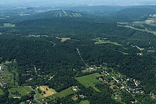
The Roundtop Mountain Resort is a resort located in York County, Pennsylvania. During the winter months the resort offers skiing, snowboarding, and snowtubing. During the spring, summer, and fall, Roundtop offers summer camp and paintball.
Little Roundtop Mountain is a summit located in the Adirondack Mountains of New York located in the Town of Benson north-northwest of the hamlet of Upper Benson.
Roundtop Mountain is a mountain located in Greene County, New York south of Haines Falls, New York. Located to the east is High Peak and located to the northwest is Clum Hill. Roundtop Mountain drains north into Kaaterskill Creek and south into Schoharie Creek.
Hack Flats is a flat located in the Catskill Mountains of New York south-southwest of Grand Gorge. White Man Mountain is located west, Roundtop is located east-northeast, and Red Mountain is located southwest of Hack Flats.
Red Mountain is a mountain located in the Catskill Mountains of New York south-southwest of Grand Gorge. White Man Mountain is located northeast of Red Mountain and Cator Roundtop is located southwest.
Red Kill Ridge is a mountain located in the Catskill Mountains of New York northeast of Denver. It is also referred to as Butternut Mountain. It is named after the nearby Red Kill. Cator Roundtop is located northwest, White Man Mountain is located north, and Red Mountain is located north of Red Kill Ridge.
Roundtop is a mountain located in the Catskill Mountains of New York east-northeast of Roxbury. Hack Flats is located west-southwest, Negro Hill is located north, and Bearpen Mountain is located southeast of Roundtop.
Negro Hill is a mountain located in the Catskill Mountains of New York northeast of Roxbury. Roundtop is located south-southwest, Clay Hill is located east and Ferris Hill is located northwest of Negro Hill.
Red Hill is a mountain located in the Catskill Mountains of New York east-south of Frost Valley. Woodhull Mountain is located northeast of Red Hill.
Mount Tobias is a mountain located in the Catskill Mountains of New York southeast of Phoenicia. Ticetonyk Mountain is located south, Tremper Mountain is located northwest, Roundtop Mountain is located southeast, and Tonshi Mountain is located southeast of Mount Tobias.
Roundtop Mountain is a mountain located in the Catskill Mountains of New York north-northwest of Wittenberg. Beetree Hill is located east-northeast, Johns Mountain is located east-northeast, and Mount Tobias is located north-northwest of Roundtop Mountain.

Roundtop Mountain is a stratovolcano located on the Aleutian island of Unimak in the U.S. state of Alaska. Its last eruption was sometime between 9,100 and 10,000 years ago. This geographic feature was first called "Dome" in 1897 by Lieutenant Commander J. F. Moser, of the U.S. Navy. Its name was reported as "Round Top" by the United States Coast and Geodetic Survey in 1902. Isanotski Peaks, the nearest higher neighbor, is positioned 5.9 mi (9 km) to the west-southwest.

