
Ulster County is a county in the U.S. state of New York. It is situated along the Hudson River. As of the 2020 census, the population was 181,851. The county seat is Kingston. The county is named after the Irish province of Ulster. The county is part of the Hudson Valley region of the state.

Shawangunk is a town in southwestern Ulster County, New York, United States. The population was 13,563 at the 2020 census. The town takes its name from its largest stream, the Shawangunk Kill. The name Shawangunk is from the language of the Lenape people. Kill is an abbreviation of the Dutch word for creek, Killitje. It is pronounced Shuh-Whan-Gung

Wawarsing is a town in Ulster County, New York, United States. The population was 12,771 at the 2020 census. The name Wawarsing was once believed to mean "a place where the streams wind" in the Lenape language, referring to the geography in the hamlet of Wawarsing; specifically, the joining of the Ver Nooy Kill and the Rondout Creek at Port Ben. The name Wawarsing was used by the Lenape to designate the current hamlet and the fields to the north and south of it for at least six miles in both directions. It is the only Lenape name known to refer to an exact location in Ulster County.
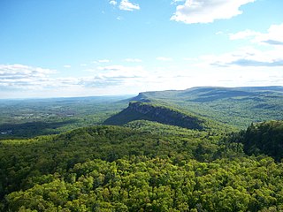
The Shawangunk Ridge, also known as the Shawangunk Mountains or The Gunks, is a ridge of bedrock in Ulster County, Sullivan County and Orange County in the state of New York, extending from the northernmost point of the border with New Jersey to the Catskills. The Shawangunk Ridge is a continuation of the long, easternmost section of the Appalachian Mountains; the ridge is known as Kittatinny Mountain in New Jersey, and as Blue Mountain as it continues through Pennsylvania. This ridge constitutes the western border of the Great Appalachian Valley.

Sam's Point Preserve, or Sam's Point Dwarf Pine Ridge Preserve, is a 4,600-acre (19 km2) preserve in Ulster County on the highest point of the Shawangunk Ridge in New York, on the Wawarsing, New York-Shawangunk town line. It is owned and managed by the New York State Office of Parks, Recreation and Historic Preservation after having previously been managed by The Nature Conservancy. Its unique environment features dwarf pitch pine trees along the ridgetop. Located within the park is Lake Maratanza, the highest lake on the ridge, and the Ellenville Fault Ice Caves.

Verkeerder Kill Falls is the highest waterfall in Sam's Point Preserve in the Shawangunk Mountains in the town of Shawangunk, Ulster County, New York. It is 187 feet (57 m) tall and is accessible via a three-mile-long (4.8 km) trail, part of the Long Path, which branches off from the main trail in Sam's Point Preserve. The waterfall is named after the stream. The waterfall may only be viewed from the top near an edge of a rocky outcrop.
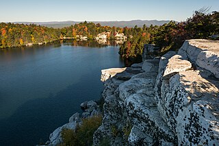
The Minnewaska State Park Preserve is a 22,275-acre (90.14 km2) preserve located on the Shawangunk Ridge in Ulster County, New York on US 44/NY 55, five miles (8.0 km) west of New York State Route 299. The park, which features scenic overlooks of the nearby Catskill Mountains, is primarily used for picnicking, hiking, mountain biking, snowshoeing and swimming. The park is managed by the Palisades Interstate Park Commission and the New York State Office of Parks, Recreation and Historic Preservation.
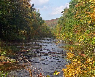
Rondout Creek is a 63.3-mile-long (101.9 km) tributary of the Hudson River in Ulster and Sullivan counties, New York, United States. It rises on Rocky Mountain in the eastern Catskills, flows south into Rondout Reservoir, part of New York City's water supply network, then into the valley between the Catskills and the Shawangunk Ridge, where it goes over High Falls and finally out to the Hudson at Kingston, receiving along the way the Wallkill River.

The Long Path is a 357-mile (575 km) long-distance hiking trail beginning in New York City, at the West 175th Street subway station near the George Washington Bridge and ending at Altamont, New York, in the Albany area. While not yet a continuous trail, relying on road walks in some areas, it nevertheless takes in many of the popular hiking attractions west of the Hudson River, such as the New Jersey Palisades, Harriman State Park, the Shawangunk Ridge and the Catskill Mountains. It offers hikers a diversity of environments to pass through, from suburbia and sea-level salt marshes along the Hudson to wilderness and boreal forest on Catskill summits 4,000 feet (1,220 m) in elevation.
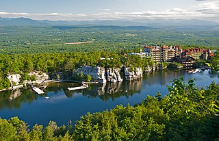
Lake Mohonk is located in Ulster County, New York, United States. It is located approximately 14 miles (23 km) northwest of Poughkeepsie. Activities on the lake are operated by Mohonk Mountain House.

Lake Maratanza is the highest lake in New York's Shawangunk Ridge at 2,245 feet (684 m) above sea level. It is within Sam's Point Preserve.
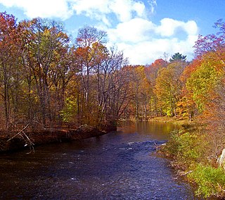
The Shawangunk Kill is a 47.2-mile-long (76.0 km) stream that flows northward through Orange, Sullivan and Ulster counties, New York, in the United States. It is the largest tributary of the Wallkill River.

The Silurian Shawangunk Formation is a mapped bedrock unit in eastern Pennsylvania, New Jersey, and New York. It is named for the Shawangunk Ridge for which it is the dominant rock type. The division of the Shawangunk between the Tuscarora Formation and Clinton Group has not been conclusively determined. The shift of nomenclature currently has the divide between Hawk Mountain and Lehigh Gap.

Thompson Ridge is a hamlet located within the town of Crawford, New York. The hamlet is served by a United States Post Office with the ZIP Code 10985. Thompson Ridge is located along NY 302 south of Pine Bush, Crawford's main population center.

Joppenbergh Mountain is a nearly 500-foot (152 m) mountain in Rosendale Village, a hamlet in the town of Rosendale, in Ulster County, New York. The mountain is composed of a carbonate bedrock overlain by glacially deposited material. It was named after Rosendale's founder, Jacob Rutsen, and mined throughout the late 19th century for dolomite that was used in the manufacture of natural cement. Extensive mining caused a large cave-in on December 19, 1899, that destroyed equipment and collapsed shafts within Joppenbergh. Though it was feared that several workers had been killed, the collapse happened while all the miners were outside, eating lunch. Since the collapse, the mountain has experienced shaking and periodic rockfalls.
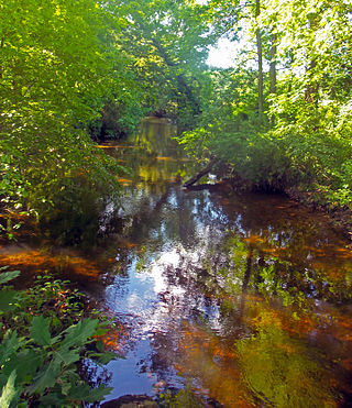
The Verkeerder Kill, sometimes Verkeerderkill and locally shortened to Kaidy Kill is an 8-mile-long (13 km) stream in Ulster County, New York, United States. It rises on the Shawangunk Ridge, in the town of Wawarsing, and flows southwards through the town of Shawangunk, toward the Shawangunk Kill, itself a major tributary of the Wallkill River. Ultimately it is a part of the Hudson River's watershed.
High Point is a mountain located in the Catskill Mountains of New York east of Ellenville. Shawangunk Ridge is located south, Mount Don Bosco is located southwest, and Napanoch Point is located north-northeast of High Point.
Mount Don Bosco is a mountain located in the Catskill Mountains of New York southeast of Ellenville. Shawangunk Ridge is located south, High Point is located northeast, Murray Hill is located east-northeast, Losees Hill is located south, and Mount Meenahga is located northwest of Mount Don Bosco.
Mount Meenahga is a mountain located on the Shawangunk Ridge of New York southeast of Ellenville. The Shawangunk Ridge is located south, High Point is located northeast, and Bear Hill is located southwest of Mount Meenahga.

