Malla Municipality is the fourth municipal section of the Loayza Province in the La Paz Department, Bolivia. Its seat is Malla.

Ch'api Qullu is a mountain in the Bolivian Cordillera Occidental situated on the western shore of the Uyuni salt pan. It is approximately 3,917 m high reaching a prominence of about 350 m. The mountain is located near the village of Canquella in the Potosí Department, Daniel Campos Province, Llica Municipality.

Wila Qullu, also Cerro Laguna, is a 4,948-metre-high (16,234 ft) mountain in the Andes located on the border of Bolivia and Chile in the Cordillera Occidental. Wila Qullu lies between the Salar de Huasco in the Tarapacá Region of Chile and the Salar de Uyuni in Bolivia. On the Bolivian side it is situated in the Potosí Department, Daniel Campos Province, Llica Municipality, Canquella Canton, north of the village of Pampa Anta.
Ch'uxña Quta is a mountain in the Bolivian Andes, about 4,920 metres (16,142 ft) high. It lies in the Kimsa Cruz mountain range, west of Wallatani Lake. It is situated in the La Paz Department, Loayza Province, Malla Municipality.
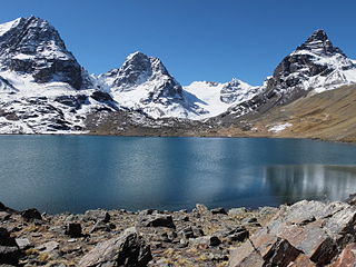
Wallatani is a 5,336-metre-high (17,507 ft) mountain in the west of the Kimsa Cruz mountain range in the Bolivian Andes. It is situated in the La Paz Department, Loayza Province, Malla Municipality. Wallatani lies west of Wallatani Lake and southeast of the mountain Ch'uxña Quta.
Qillqata is a 3,922-metre-high (12,867 ft) mountain in the Bolivian Andes. It lies in the La Paz Department, Loayza Province, Malla Municipality. Qillqata is situated south-west of Malla. The river Malla Jawira flows along its southern slopes.
Malla Jawira is a river in the La Paz Department in Bolivia. It is a right tributary of the Luribay River whose waters flow to the La Paz River.
The Ch'alla Jawira which upstream is named Ch'api K'uchu and downstream successively is called Tupa Jawira and Qura Jawira is a river in the La Paz Department in Bolivia. It is a right affluent of the Aqhuya Jawira whose waters flow to the Desaguadero River.
Pukarani is a mountain in the Bolivian Andes which reaches a height of approximately 3,720 m (12,200 ft). It is located in the La Paz Department, Loayza Province, Malla Municipality. Pukarani lies northwest of Chuqi Tira. The Malla Jawira flows along its south-western slopes.
Chuqi Tira is a mountain in the Bolivian Andes which reaches a height of approximately 4,000 m (13,000 ft). It is located in the La Paz Department, Loayza Province, Malla Municipality. Chuqi Tira lies southeast of Pukarani. The Malla Jawira flows along its southern and south-western slopes.
Jach'a Ch'apini is a mountain in the Bolivian Andes which reaches a height of approximately 3,500 m (11,500 ft). It is located in the La Paz Department, Loayza Province, Luribay Municipality. Jach'a Ch'apini lies at the Luribay River, southwest of Jach'a Qullu and northwest of Ch'apini.
Ch'apini is a 3,474-metre-high (11,398 ft) mountain in the Bolivian Andes. It is located in the La Paz Department, Loayza Province, Luribay Municipality. Ch'apini lies at the Luribay River, southeast of Jach'a Ch'apini.
Chullpani is a mountain in the Bolivian Andes which reaches a height of approximately 3,900 m (12,800 ft). It is located in the La Paz Department, Loayza Province, Luribay Municipality. Chullpani lies northeast of Ch'apini.
Ch'api Qullu is a 3,478-metre-high (11,411 ft) mountain in the Bolivian Andes. It is located in the La Paz Department, Loayza Province, Luribay Municipality. Ch'api Qullu lies northeast of Jach'a Ch'uñu Uma.
Jisk'a Uma is a mountain in the Bolivian Andes which reaches a height of approximately 3,940 m (12,930 ft). It is located in the La Paz Department, Loayza Province, Luribay Municipality. Jisk'a Uma lies northwest of Nasa Q'ara and southeast of Ch'apini.
P'iq'iñ Q'ara or P'iq'iñ Qala is a mountain in the Andes of Bolivia which reaches a height of approximately 4,960 m (16,270 ft). It is located in the La Paz Department, Loayza Province, Malla Municipality, north of Malla. The Malla Jawira flows along its eastern slopes.
Malla Qullu is a mountain in the La Paz Department in the Andes of Bolivia. It is located in the Loayza Province, Malla Municipality, northeast of Malla. Malla Qullu lies south of P'iq'iñ Q'ara. The Malla Jawira flows along its eastern slopes.
Turi Turini is a mountain in the La Paz Department in the Andes of Bolivia. It is located in the Loayza Province, Malla Municipality, northeast of Mallachuma.
Malla Jaqhi is a mountain in the Bolivian Andes which reaches a height of approximately 4,520 m (14,830 ft). It is located in the La Paz Department, Aroma Province, Sica Sica Municipality. Malla Jaqhi lies southwest of Llallawa.
Ch'apiri is a 4,302-metre-high (14,114 ft) mountain in the Andes of Bolivia. It is located in the Oruro Department, Sajama Province, Curahuara de Carangas Municipality. It lies east of a village of that name. The Ch'apiri River originates at the mountain.. It flows to Curahuara de Carangas in the north.