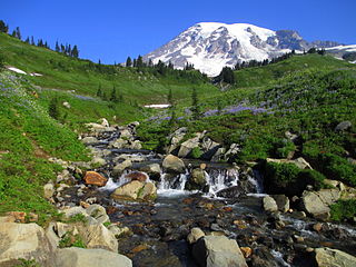
Mount Rainier National Park is an American national park located in southeast Pierce County and northeast Lewis County in Washington state. The park was established on March 2, 1899, as the fourth national park in the United States, preserving 236,381 acres including all of Mount Rainier, a 14,410-foot (4,390 m) stratovolcano. The mountain rises abruptly from the surrounding land with elevations in the park ranging from 1,600 feet to over 14,000 feet (490–4,300 m). The highest point in the Cascade Range, Mount Rainier is surrounded by valleys, waterfalls, subalpine meadows, and 91,000 acres of old-growth forest. More than 25 glaciers descend the flanks of the volcano, which is often shrouded in clouds that dump enormous amounts of rain and snow.
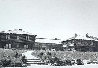
The Yakima Park Stockade Group, also known as North and South Blockhouses, Museum, and Stockade at Sunrise, is a building complex consisting of four log buildings at the Sunrise Visitors Center area in the northeast part of Mount Rainier National Park. The complex is architecturally significant as a particularly fine example of rustic frontier log architecture. The first of the blockhouses and the stockade were built in 1930, while the second blockhouse followed in 1943. It was declared a National Historic Landmark in 1987. It is in turn part of the Mount Rainier National Historic Landmark District, which encompasses the entire park and which recognizes the park's inventory of Park Service-designed rustic architecture.

The Zion – Mount Carmel Highway is a 25-mile (40 km) long road in Washington and Kane counties in southern Utah, United States, that is listed on the National Register of Historic Places and is a National Historic Civil Engineering Landmark.

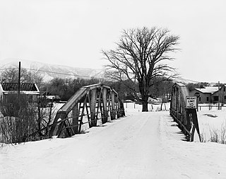
The Hayden Arch Bridge is a concrete arch bridge on old US 14/US 16 near Cody, Wyoming. It is the only example of its kind in Wyoming. Built in 1924–25, the single-span bridge spans 115 feet (35 m) with two smaller approach arches between rock canyon walls. The bridge carries the Cody-Yellowstone Highway across the Shoshone River with a shallow open-spandrel central arch and nominally arched approach spans. The bridge is named after C. E. Hayden, an engineer with the Wyoming State Highway Department, who designed the bridge and supervised its construction. It was built by H. S. Crocker of Denver, Colorado.

The historical buildings and structures of Zion National Park represent a variety of buildings, interpretive structures, signs and infrastructure associated with the National Park Service's operations in Zion National Park, Utah. Structures vary in size and scale from the Zion Lodge to road culverts and curbs, nearly all of which were designed using native materials and regional construction techniques in an adapted version of the National Park Service Rustic style. A number of the larger structures were designed by Gilbert Stanley Underwood, while many of the smaller structures were designed or coordinated with the National Park Service Branch of Plans and Designs. The bulk of the historic structures date to the 1920s and 1930s. Most of the structures of the 1930s were built using Civilian Conservation Corps labor.
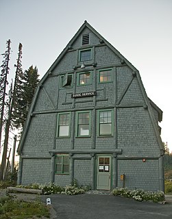
The Sunrise Comfort Station (S-310) is a comfort station in Mount Rainier National Park, Washington, USA. Built around 1930, the building was designed by Thomas Chalmers Vint of the National Park Service in association with landscape architect E.A. Davidson. The structure was part of a planned ensemble at what was then called Yakima Park, high on the northern flank of Mount Rainier. Similar structures may be found at the Ohanapecosh, Longmire and White River campgrounds in the park. The low building is framed in peeled logs on a stone foundation, set into a hillside and surrounded by native landscaping.

The Christine Falls Bridge is a reinforced concrete arch bridge in Mount Rainier National Park, spanning Van Trump Creek at Christine Falls. The bridge was built in 1927–1928 by contractor J. D. Tobin of Portland, Oregon, who built the Narada Falls Bridge at the same time. The arch has a three-centered profile and spans 56 feet (17 m). The bridge is 30 feet (9.1 m) wide. It was faced with rubble stonework and is an example of National Park Service Rustic design.

The Wonderland Trail is an approximately 93-mile (150 km) hiking trail that circumnavigates Mount Rainier in Mount Rainier National Park, Washington, United States. The trail goes over many ridges of Mount Rainier for a cumulative 22,000 feet (6,700 m) of elevation gain. The trail was built in 1915.

The Narada Falls Bridge is a reinforced concrete arch bridge in Mount Rainier National Park, spanning the Paradise River above Narada Falls. The bridge was built in 1927-1928 by contractor J.D. Tobin of Portland, Oregon, who built the Christine Falls Bridge at the same time. The arch spans 36 feet (11 m). The bridge is 20 feet (6.1 m) wide, with an additional 3.5 feet (1.1 m) on either side for sidewalks. It was faced with rubble stonework and is an example of National Park Service Rustic design. The bridge is not open for public traffic, and leads to the Narada park utility area

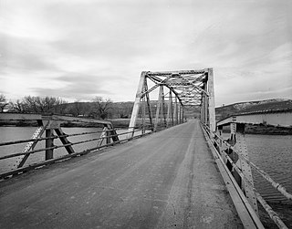
The White River Bridge was built in 1929 in Mount Rainier National Park as part of the Yakima Park Road project. The new road was planned to open up access to the northeastern portion of the park. The bridge, spanning the White River, was built by contractor John D. Tobin of Portland, Oregon, who had previously built the Narada Falls Bridge and the Christine Falls Bridges, both listed on the National Register of Historic Places. Plans for the bridge were drawn by the National Park Service Branch of Plans and Designs in the National Park Service Rustic style, with construction supervision by NPS landscape architect Ernest A. Davidson. The three-centered arch spans 60 feet (18 m), with a stone-faced concrete structure.
The Paradise Historic District comprises the historic portion of Paradise developed area of Mount Rainier National Park. The subalpine district surrounds its primary structure, the Paradise Inn, a rustic-style hotel built in 1917 to accommodate visitors to the park. The Paradise Inn is a National Historic Landmark. Five other buildings are included in the district. The district was placed on the National Register of Historic Places on March 13, 1991. It is part of the Mount Rainier National Historic Landmark District, which encompasses the entire park and which recognizes the park's inventory of Park Service-designed rustic architecture.

The Tipsoo Lake Comfort Station was designed by the National Park Service Branch of Plans and Designs in the National Park Service Rustic style and built in Mount Rainier National Park by the Civilian Conservation Corps in 1934. The design was supervised by Park Service Chief Architect Thomas Chalmers Vint, and is similar to the Sunrise Comfort Station in the central portion of the park. Located near the park's northern entrance, two comfort station were planned to be part of a developed area in the vicinity of Tipsoo and Chinook Pass, which was never developed beyond the toilet facilities and an entrance arch. One of these survives and remains in use. The public toilet facility features rough stonework to window sill level, with a framed wall above and a log-framed roof with cedar shingles.

The St. Andrews Patrol Cabin was built by the National Park Service in 1922 as part of a network of stations near the boundaries of Mount Rainier National Park for rangers on patrol. The one-room log structure stands along St. Andrews Creek and St. Andrews Creek Trail near the Westside Road and the western boundary of the national park. The exterior of the cabin features a porch to the front. The interior is finished with varnished logs and tongue and groove flooring. The cabin was placed on the National Register of Historic Places on March 13, 1991. It is part of the Mount Rainier National Historic Landmark District, which encompasses the entire park and which recognizes the park's inventory of Park Service-designed rustic architecture.

The Nisqually Entrance Historic District comprises the first public entrance to Mount Rainier National Park. The district incorporates the log entrance arch typical of all Mount Rainier entrances, a log frame ranger station and checking station, a comfort station and miscellaneous service structures, all built around 1926, as well as the 1915 Superintendent's Residence and the 1908 Oscar Brown Cabin, the oldest remaining structure in the park. The buildings in the district conform to the principles of the National Park Service Rustic style that prevailed in park design of the 1920s and 1930s.

The St. Andrews Creek Bridge was built in 1930-31 as part of the West Side Road in Mount Rainier National Park. The bridge spans 26 feet (7.9 m) and is almost 34 feet (10 m) wide, carrying a two-lane road on a stone-faced concrete bridge. The West Side Road was planned to link the Nisqually and Carbon River entrances to the park, but only 13 miles (21 km) were completed in six years.

The South Puyallup River Bridge was built in 1930–31 in Mount Rainier National Park as part of the West Side Road project, planned to link the park's Nisqually and Carbon River entrances. The stone-faced reinforced concrete bridge was designed by the National Park Service and the Bureau of Public Roads. It spans 42 feet (13 m) and is almost 35 feet (11 m) wide, carrying two lanes of traffic.
Architects of the National Park Service are the architects and landscape architects who were employed by the National Park Service (NPS) starting in 1918 to design buildings, structures, roads, trails and other features in the United States National Parks. Many of their works are listed on the National Register of Historic Places, and a number have also been designated as National Historic Landmarks.
The DFU Elk Mountain Bridge was a Warren pony truss bridge located near Elk Mountain, Wyoming, which carried Carbon County Road 120-1 over the Medicine Bow River. The bridge was built in 1823 by contractor D. B. Miller. While the bridge's design is mainly a Warren truss, the top chord of the bridge is reminiscent of a Parker truss. At 102 feet (31 m) long, the bridge is the longest of its design in the Wyoming county highway system.
The DUX Bessemer Bend Bridge was a Warren through truss bridge in Bessemer Bend, Wyoming, which carried Natrona County Road CN1-58 across the North Platte River. The bridge was built from 1921 to 1922. When nominated to the National Register of Historic Places in 1982, it was one of only three Warren through truss bridges remaining on Wyoming county highways. In addition, the bridge was located at the site of a historic river crossing on the Oregon Trail.

Wilkeson Arch is a monumental gateway structure at the west entrance to Wilkeson, Washington. The stone and timber structure was built in 1925 by the Wilkeson Booster Club, at a cost of $2000. It is similar in design to the Chinook Pass, Nisqually and White River entrance arches in nearby Mount Rainier National Park, deriving its style from the National Park Service Rustic style prevailing in the national park structures of the time. The arch was intended to promote tourism and the local products, coal and sandstone.

