The Yakima Park Stockade Group, also known as North and South Blockhouses, Museum, and Stockade at Sunrise, is a building complex consisting of four log buildings at the Sunrise Visitors Center area in the northeast part of Mount Rainier National Park. The complex is architecturally significant as a particularly fine example of rustic frontier log architecture. The first of the blockhouses and the stockade were built in 1930, while the second blockhouse followed in 1943. It was declared a National Historic Landmark in 1987. It is in turn part of the Mount Rainier National Historic Landmark District, which encompasses the entire park and which recognizes the park's inventory of Park Service-designed rustic architecture.

The Generals' Highway Stone Bridges, built in 1930, are part of the Generals' Highway from the General Grant Grove of giant sequoias in Kings Canyon National Park through Sequoia National Park. One bridge spans the Marble Fork of the Kaweah River in a wooded setting, while the other, similar bridge spans Clover Creek in a bare canyon.

The Floor of the Valley Road, also known as the Zion Canyon Scenic Drive, follows the canyon of the North Fork of the Virgin River, also known as Zion Canyon, through Zion National Park, Utah, USA. A precursor to the present nine-mile road was first built in 1916, but was later redesigned by the National Park Service Branch of Plans and Designs to highlight the natural features of the valley while presenting a natural-appearing built environment. The road begins at the south boundary of the park and ends at the Temple of Sinawava.

The Zion – Mount Carmel Highway is a 25-mile (40 km) long road in Washington and Kane counties in southern Utah, United States, that is listed on the National Register of Historic Places and is a National Historic Civil Engineering Landmark.

The historical buildings and structures of Zion National Park represent a variety of buildings, interpretive structures, signs and infrastructure associated with the National Park Service's operations in Zion National Park, Utah. Structures vary in size and scale from the Zion Lodge to road culverts and curbs, nearly all of which were designed using native materials and regional construction techniques in an adapted version of the National Park Service Rustic style. A number of the larger structures were designed by Gilbert Stanley Underwood, while many of the smaller structures were designed or coordinated with the National Park Service Branch of Plans and Designs. The bulk of the historic structures date to the 1920s and 1930s. Most of the structures of the 1930s were built using Civilian Conservation Corps labor.

The Kettle Falls Bridges is the collective name for a pair of steel cantilever bridges carrying State Route 20/U.S. Route 395 and the Kettle Falls International Railway across the Columbia River at Kettle Falls, Washington. The south bridge carries motor vehicle traffic while the similar northern span is used for rail.
The Sunrise Comfort Station (S-310) is a comfort station in Mount Rainier National Park, Washington, USA. Built around 1930, the building was designed by Thomas Chalmers Vint of the National Park Service in association with landscape architect E.A. Davidson. The structure was part of a planned ensemble at what was then called Yakima Park, high on the northern flank of Mount Rainier. Similar structures may be found at the Ohanapecosh, Longmire and White River campgrounds in the park. The low building is framed in peeled logs on a stone foundation, set into a hillside and surrounded by native landscaping.
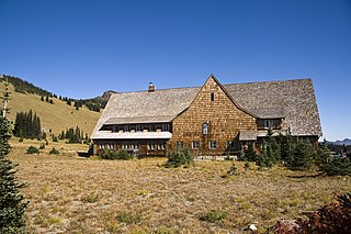
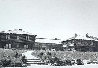
The Sunrise Historic District, also known as the community of Sunrise, Washington, is located at approximately 6,400 feet (2,000 m) on a ridge overlooking the northeast side of Mount Rainier in Mount Rainier National Park. The district comprises seven individual structures designed in accordance with the principles of the National Park Service Rustic style. The area is inhabited and open to the public only during a brief period in the summer season.

The White River Entrance to Mount Rainier National Park is a complex of buildings built between 1929 and 1931 to accommodate visitors arriving on the Yakima Park Highway, in the northeastern portion of the park. Like most of the structures in Mount Rainier, the buildings are designed in the National Park Service Rustic style, using natural stone and log materials. The historic district includes the 1933 Men's Mess Hall and Dormitory, believed to be the only surviving camp structure built by the Civilian Conservation Corps in the park.

The Chinook Pass Entrance Arch marks the east entrance to Mount Rainier National Park. The rectangular log entry arch is one of several placed at the entrances to the park. It was designed in 1933 by the National Park Service Branch of Plans and Designs, and was built in 1936 by the Civilian Conservation Corps. The arch consists of two stone abutments carrying horizontal logs over the road. The arch functions as a bridge, carrying a horse trail, which is now part of the Pacific Crest Trail.

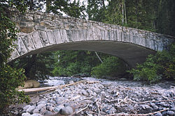
The Christine Falls Bridge is a reinforced concrete arch bridge in Mount Rainier National Park, spanning Van Trump Creek at Christine Falls. The bridge was built in 1927–1928 by contractor J. D. Tobin of Portland, Oregon, who built the Narada Falls Bridge at the same time. The arch has a three-centered profile and spans 56 feet (17 m). The bridge is 30 feet (9.1 m) wide. It was faced with rubble stonework and is an example of National Park Service Rustic design.

The Wonderland Trail is an approximately 93-mile (150 km) hiking trail that circumnavigates Mount Rainier in Mount Rainier National Park, Washington, United States. The trail goes over many ridges of Mount Rainier for a cumulative 22,000 feet (6,700 m) of elevation gain. The trail was built in 1915.

The Narada Falls Bridge is a reinforced concrete arch bridge in Mount Rainier National Park, spanning the Paradise River above Narada Falls. The bridge was built in 1927–1928 by contractor J. D. Tobin of Portland, Oregon, who built the Christine Falls Bridge at the same time. The arch spans 36 feet (11 m). The bridge is 20 feet (6.1 m) wide, with an additional 3.5 feet (1.1 m) on either side for sidewalks. It was faced with rubble stone masonry and is an example of National Park Service Rustic design. The bridge is not open for public traffic, and leads to the Narada park utility area.

The Narada Falls Comfort Station was built in Mount Rainier National Park by the National Park Service and the Civilian Conservation Corps in 1941–42. The public toilet building is close to Narada Falls in the south central portion of the park. Initial work by the Park Service encountered substantial rock excavation, with the subsequent cost overrun requiring the Park Service to use CCC labor to complete the project. The building features stone masonry walls to window sill level, woor framed upper walls, and a timber framed roof. The interior comprises a waiting room and a toilet facility. The design was by the Western Region Landscape Engineering Division, with plan approval by Thomas Chalmers Vint, NPS Chief of Planning.

The St. Andrews Creek Bridge was built in 1930-31 as part of the West Side Road in Mount Rainier National Park. The bridge spans 26 feet (7.9 m) and is almost 34 feet (10 m) wide, carrying a two-lane road on a stone-faced concrete bridge. The West Side Road was planned to link the Nisqually and Carbon River entrances to the park, but only 13 miles (21 km) were completed in six years.

The South Puyallup River Bridge was built in 1930–31 in Mount Rainier National Park as part of the West Side Road project, planned to link the park's Nisqually and Carbon River entrances. The stone-faced reinforced concrete bridge was designed by the National Park Service and the Bureau of Public Roads. It spans 42 feet (13 m) and is almost 35 feet (11 m) wide, carrying two lanes of traffic.

The Yosemite Valley Bridges are eight bridges in the Yosemite Valley of Yosemite National Park, most of them spanning the Merced River. Five of them were built in 1928, with the remainder built between 1921 and 1933. The bridges feature a concrete structure faced with local stone, in an elliptical or three-centred arch configuration. They are notable for their uniform character and for their conformance to tenets of the National Park Service rustic style. Design work for the seven newer bridges was by George D. Whittle of the San Francisco District Office of the U.S. Bureau of Public Roads for the National Park Service. Concrete bridges were chosen at the urging of Thomas Chalmers Vint of the Park Service, in lieu of alternative designs for steel truss bridges, or suspension bridges suggested by the park superintendent.
Architects of the National Park Service are the architects and landscape architects who were employed by the National Park Service (NPS) starting in 1918 to design buildings, structures, roads, trails and other features in the United States National Parks. Many of their works are listed on the National Register of Historic Places, and a number have also been designated as National Historic Landmarks.

The Orient Bridge, which spans the Kettle River between Ferry County, Washington and Stevens County, Washington, was built in 1909. It was listed on the National Register of Historic Places.

The New Hampton Pony Pratt Truss Bridge is a historic pony Pratt truss bridge on Shoddy Mill Road in New Hampton of Lebanon Township, Hunterdon County, New Jersey. It crosses the Musconetcong River between Lebanon Township, Hunterdon County and Washington Township, Warren County. It was designed by Francis C. Lowthorp and built in 1868 by William Cowin of Lambertville, New Jersey. The bridge was added to the National Register of Historic Places on July 26, 1977 for its significance in engineering, industry and transportation. It is one of the few early examples of iron Pratt truss bridges remaining in the United States. It was later documented by the Historic American Engineering Record in 1991. It was added as a contributing property to the New Hampton Historic District on April 6, 1998.