
The San Carlos Apache Indian Reservation, in southeastern Arizona, United States, was established in 1872 as a reservation for the Chiricahua Apache tribe as well as surrounding Yavapai and Apache bands removed from their original homelands under a strategy devised by General George Crook of setting the various Apache tribes against one another. Once nicknamed "Hell's Forty Acres" during the late 19th century due to poor health and environmental conditions, modern San Carlos Apaches operate a Chamber of Commerce, the Apache Gold and Apache Sky Casinos, a Language Preservation program, a Culture Center, and a Tribal College.

Black Hills National Forest is located in southwestern South Dakota and northeastern Wyoming, United States. The forest has an area of over 1.25 million acres (5,066 km2) and is managed by the Forest Service. Forest headquarters are located in Custer, South Dakota. There are local ranger district offices in Custer, Rapid City, and Spearfish in South Dakota, and in Sundance, Wyoming.

New York State Route 278 (NY 278) is a state highway in Rensselaer County, New York, in the United States. The route, 1.51 miles (2.43 km) in length, is located in a rural section of the town of Brunswick. It climbs uphill from a southern terminus at NY 2 in the hamlet of Clums Corners to its northern end at NY 7. The road was taken over by the state of New York in 1905 and designated NY 278 c. 1938.

John Philip Clum was an Indian agent for the San Carlos Apache Indian Reservation in the Arizona Territory. He implemented a limited form of self-government on the reservation that was so successful that other reservations were closed and their residents moved to San Carlos. Clum later became the first mayor of Tombstone, Arizona Territory, after its incorporation in 1881. He also founded the still-operating The Tombstone Epitaph on May 1, 1880. He later served in various postal service positions across the United States.

Berlin Mountain is a 2,818-foot-tall (859 m) prominent peak in the Taconic Mountains of western New England and is located adjacent to Massachusetts's border with New York State. It is the highest point in Rensselaer County. The summit and west side of the mountain are located in New York; the east side lies within Williamstown, Massachusetts. The mountain is a bald, notable for its grassy summit and expansive views of the Hudson River Valley to the west. The 37-mile (60 km) Taconic Crest Trail traverses the mountain. Several other hiking trails approach the summit from the east. Much of the upper slopes and summit are within protected conservation land. Historically the lower slopes of the mountain were farmed heavily throughout the 19th Century. In addition to agriculture, there are several remnants of charcoal kilns located on the mountain that produced fuel for iron smelting.

Clums Corners is a hamlet in the town of Brunswick in Rensselaer County, New York, United States. It is located at the intersection of New York Route 2, New York Route 278, and Tamarac Road. Tamarac Secondary and Elementary Schools are located nearby. The site is so named for the Clum family—specifically James Clum and later his son Orlin—who ran a blacksmith shop during the late 19th century and early 20th century.
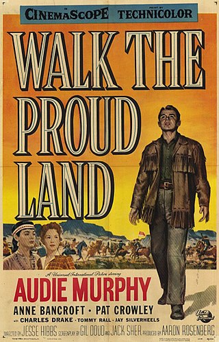
Walk the Proud Land is a 1956 American CinemaScope Technicolor Western film directed by Jesse Hibbs and starring Audie Murphy and future Academy Award winner Anne Bancroft. Filmed at Old Tucson Studios, it recounts the first successful introduction of limited self-government by John Clum (1851–1932), Indian agent for the San Carlos Apache Indian Reservation in the Arizona Territory and is based on the 1936 biography Apache Agent by his son Woodworth Clum (1878-1946).

Haines Falls is a hamlet located east of Tannersville in the Town of Hunter, in Greene County, New York, United States. Haines Falls is located at 42°11′45″N74°5′49″W. The hamlet of Haines Falls was always a mountain resort town, unlike Hunter and Palenville which had tanneries. Haines Falls is at the head of Kaaterskill Clove and is the former site of the Catskill Mountain House, Kaaterskill Hotel, and Laurel House which sat atop the famous Kaaterskill Falls. In 1825, Thomas Cole, founder of the Hudson River School of landscape painters, did his first Catskill mountain paintings in Haines Falls: Lake with Dead Trees at South Lake and the Kaaterskill Falls.

McCauley Mountain is a summit and ski resort in the Town of Webb, Herkimer County, New York. It is located just outside the hamlet of Old Forge, in the south-western area of the Adirondack Mountains.

Clay Beauford was an American army officer, scout and frontiersman. An ex-Confederate soldier in his youth, he later enlisted in the U.S. Army and served with the 5th U.S. Cavalry during the Indian Wars against the Plains Indians from 1869 to 1873. He acted as a guide for Lieutenant Colonel George Crook in his "winter campaign" against the Apaches and received the Medal of Honor for his conduct.

Rum Hill is a mountain located in Central New York Region of New York northwest of the Hamlet of Pierstown. Red House Hill is located southeast, Metcalf Hill is located south, Allen Lake and Mohegan Hill are located north-northwest and Otsego Lake is located east of Rum Hill.
Klock Hill is a mountain located in Central New York region of New York southwest of Burlington, New York.
Dairy Hill is a 1,844-foot-tall (562 m) summit located in Central New York Region of New York located in the Town of Norway in Herkimer County, southeast of Norway. The mountain is the former location of a 79-foot-6-inch-tall (24.23 m) steel fire lookout tower.
Frost Hill is a mountain in the Finger Lakes Region of New York. It is located west of Bristol Springs in Ontario County. At an elevation of 2,284 feet (696 m), the mountain is the highest point in Ontario County. It is about 1.25 miles (2.01 km) southwest of the 2,150-foot (660 m) Worden Hill, where Bristol Mountain Ski Resort is.
Roundtop Mountain is a mountain located in Greene County, New York south of Haines Falls, New York. Located to the east is High Peak and located to the northwest is Clum Hill. Roundtop Mountain drains north into Kaaterskill Creek and south into Schoharie Creek.
Red Hill is a mountain located in the Catskill Mountains of New York east-south of Frost Valley. Woodhull Mountain is located northeast of Red Hill.
Morgan Hill is a mountain in the central part of the state of New York. It is located north-northeast of Truxton in Cortland County with a small portion in Onondaga County. The portion of the mountain within Onondaga County is the highest point in the county.
Gallis Hill is a 794-foot-tall (242 m) mountain in the Catskill Mountains region of New York. It is located northwest of Kingston in Ulster County. Jockey Hill is located north-northeast, and Morgan Hill is located west of Gallis Hill. In 1927, the Conservation Department built a steel fire lookout tower on the mountain. In 1950, the tower was closed and disassembled then moved to Overlook Mountain, where it still remains today.
Leonard Hill is a 2,592-foot-tall (790 m) mountain in Schoharie County, New York. It is located east-southeast of North Blenheim. Safford Hill is located northwest and Hubbard Hill is located southeast of Leonard Hill. In 1948, the Conservation Commission built an 80-foot-tall (24 m) steel fire lookout tower on the mountain. The tower ceased fire watching operations at the end of the 1988 season and was officially closed in early 1989. The tower remains on the summit, but is closed to the public. A local group is planning to restore the tower and reopen it to the public.
Washburn Mountain is a 1,496-foot-tall (456 m) mountain in New York. It is located south-southeast Copake Falls in Columbia County. From 1932 to 1964, the mountain was the location of a 60-foot-tall (18 m) steel fire lookout tower now located on Beebe Hill. Alander Mountain is located southeast of Washburn Mountain.

