College Hill, St. Louis

Last updated
College Hill
Arch and Water Tower (10121677403).jpg
Arch visible in background with Bissell Water Tower, October 2013
STL Neighborhood Map 66.PNG
Location (red) of College Hill within St. Louis
Country United States
State Missouri
City St. Louis
Wards 21, 3
Government
  Aldermen
Area
  Total0.39 sq mi (1.0 km2)
Population
 (2020) [1]
  Total1,243
  Density3,200/sq mi (1,200/km2)
ZIP code(s)
Part of 63107
Area code(s) 314
Website stlouis-mo.gov

College Hill is a neighborhood of the City of St. Louis, Missouri. The name College Hill was given to this area because it was the location of the Saint Louis University College Farm. This area, bounded generally by Warne Ave., O'Fallon Park, I-70, Grand Boulevard, and W. Florissant Ave., was acquired by the University for garden and recreation purposes in 1836. It was subdivided in the early 1870s.

Contents

The Bissell Mansion, the Old Water Tower at 20th Street and East Grand Avenue, and the Red Water Tower at Bissell Street and Blair Avenue are mainstays in this old Northside neighborhood and are testimony of a rich historical heritage. The housing of this neighborhood dates back between 1880 and 1920. Townhouses and four family flats predominate the neighborhood, with a mixture of single-family brick dwellings. The houses have large yards and are ideal for landscaping. The homes located near the crest of the hillside bluff enjoy a view of the river and its valleys. Nearly half of the housing dwellings are owner-occupied. Historically the area's commercial center has been concentrated along East Grand around the Old Water Tower with a strip along W. Florissant Avenue.

History

College Hill Farm

Much of what is presently identified as College Hill grew out of a 300-acre farmstead purchased by Saint Louis University in 1836. At that time, the university was engaged in transferring the location of its seminary from Florissant to the City of St. Louis. Although the university constructed a building for such purposes on Washington Avenue by the early 1830s, residential development in and around the area prompted trustees to search for a more suitable location, which would provide ample space for growth. What soon became known as College Hill Farm (in relation to the university’s ownership) was partially developed when plans were laid out in 1836. During the initial phases of construction, the project’s contractor died, and plans were placed on hold. Though Saint Louis University intended to continue the College Hill campus project, this was abandoned when in 1843, plans turned toward developing a central downtown campus. A second attempt by the university to use the College Hill property arose in 1858, when at least one building was constructed to support a theological school. The effort was abandoned two years later when the theology program transferred to Boston. In 1867, the university purchased what became its current campus, a parcel measuring 400 feet on Grand Avenue by 360 feet on Lindell Avenue for a cost of $52,600. The acquisition was funded through the subdivision and sale of the university’s College Hill property. [2]

Lowell

Prior to its associations with Saint Louis University, for which College Hill was named, a portion of the neighborhood was the Town of Lowell, platted in 1849 by E.C. Hutchinson, Josephine Hall, Edward F. Pittman, Robert Hall, and Wm. Garnett. Lowell consisted of a 40-block area between the Mississippi River and Bellefontaine Road, from Grand Avenue to Adelaide, formerly O’Fallon Avenue. The university’s holdings (College Hill Farm) adjoined Lowell at the west, extending south from O’Fallon Park between the Bellefontaine Road and Penrose, formerly Belle Street, and E. Prairie, formerly Bryan, and Adelaide, formerly O’Fallon Avenue. [3]

In 1876, the City of St. Louis expanded its boundaries, incorporating Lowell, by which time the university farmstead had been subdivided and sold for development. By the early 1880s, all but a single parcel bounded by Bellefontaine Road (east), E. Linton Avenue (north), Blair Street (west; formerly Henry Street) and DeSoto Avenue (south) had been subdivided into small lots. The larger undivided parcel remained under the ownership of Saint Louis University and supported a single building (likely constructed for the theological school). [4] [5]

The street grid for Lowell follows the Mississippi River, and is at a slightly different angle than the grid in Hyde Park. The Lowell grid extends into the O'Fallon Park and Walnut Part East neighborhoods, but eventually intersects with the St. Charles Rock Road grid. Streets on the Lowell grid include College Avenue and Obear Street.

Architecture

O'Fallon Park

The largest land owner in the area was Colonel John O'Fallon, whose holdings of over 600 acres (2.4 km2) embraced the present O'Fallon Park. This was the site of the mansion. It was said that during excavations for its foundations during the 1850s that Indian and mound builder's artifacts were discovered. The house was quite large and contained more than fifty rooms in its four stories. Colonel O'Fallon was born in Kentucky in 1791 and came to St. Louis as a young man to work as an Indian agent under his uncle, General William Clark.

After making a fortune in the Indian trade, O'Fallon purchased the large tract on Bellfontaine Road. He chose the highest point on the property for the location of his mansion which he named "Athlone" after his father's Irish birthplace. Keeping the present park sit as his estate, O'Fallon sold off the remainder at a large profit. He augmented his fortune in railroading and banking and later donated one million dollars to local schools and colleges. Following Colonel O'Fallon's death in 1865, the estate was sold to the city for a park in 1875 for $260,000. The mansion was partially burned in the same year and was razed in 1893.

O'Fallon Park became popular as a driving park and picnic grounds in the late decades of the nineteenth century. During the 1890s the lake was constructed and an observatory for sight seeing was erected. An island was placed in the lake in 1904 and retaining walls were erected around it to hold its earthen banks. Boating was introduced on the lake following the erection of the boat house in 1908. Electric lighting came to the park in 1914 and some plaster statuary was placed there after the World's Fair. The statues have long since disappeared.

The park originally covered 150 acres (0.61 km2) and was expanded in 1917 when the Catholic Archdiocese donated an adjacent area of eight and a half acres. This was a former cemetery which became a bird sanctuary after its acquisition by the City. The park's area was reduced by five and a half acres in 1954 when the State Highway Department acquired the right of way for the Mark Twain Expressway. [6]

Bissell Point Water Works

Bissell Point Pumping Station during the Flood of June 1903 "Flood of June 1903 from Stand Pipe No. 2".jpg
Bissell Point Pumping Station during the Flood of June 1903

The vicinity of East Grand Avenue is tied to the development of the City Water Works system. The need for a new waterworks became apparent in 1863, when the City's existing facility had become incapable of furnishing a plentiful water supply. In that year the state passed an act for the new waterworks, creating a Board of Commissioners to administer it and authorizing insurance of $3,000,000 in bonds for construction.

In 1865, the Board appointed James P. Kirkwood as Chief Engineer. Mr. Kirkwood devised a plan to locate a low service pumping station, settling basins, filter beds at Chain of Rocks, with a high service station at Baden and reservoirs at Compton Hill and near Wellston. This plan was rejected in 1866 in favor of a plant at Bissell Point, with basins but no filtering works. The site at Bissell Point was originally a portion of the Lewis and Bissell estate. In 1867, Kirkwood was succeeded as engineer by Thomas J. Whitman, who supervised construction of the Bissell Point plant (Whitman was a brother of the poet Walt Whitman).

Upon completion in 1869 the Bissell Point high service pumping station consisted of handsome, one and two story buildings of brick with cut stone trim. On a pediment above the main entrance were two sculptured figures symbolizing the "Union of the Waters" of the Missouri and Mississippi Rivers. The plan included an engine room and boiler house with an ornamental smokestack 134 feet (41 m) high. Large settling basins were located on the site. [6]

Water Towers

STL Bissell and Blair Water Tower 01.JPG
STL North Grand Water Tower.JPG
The "new" Bissell Water Tower (left) and the "old" Grand Avenue Water Tower (right) are national historic landmarks in the College Hill neighborhood.

Two standpipe water towers which were connected to the Bissell Point plant are on the National Register of Historic Places. The Grand Avenue Water Tower, built in 1871, and the Bissell Tower, built in 1887.

The Bissell Point plant included a standpipe, which is the present Grand Avenue Water Tower at 20th Street and East Grand Avenue, and the reservoir at Compton Hill. Designed by George I. Barnett, the first architect to receive training abroad, [7] the tower on East Grand was placed in service in 1871, and was considered to be the largest perfect Corinthian column in existence, reaching a height of 154 feet (47 m). In the late 1920s lights were placed on top of the Corinthian tower to serve as aviation beacons. They were extinguished in World War II as a security precaution and were reactivated in 1949 to guide flyers to Lambert Field. The lights are presently not in use and the tower itself has not been used for its original purpose for many years.

Another water tower landmark in the area is the Red Water Tower or Bissell Tower. The 206-foot (63 m) high tower was built in 1887 at a cost of $79,789, and designed by architect William S. Eames, who was then the assistant city water commissioner. Sometimes called the "New Red" tower, it was erected as a stand pipe to augment the "Old Water Tower" on Grand, and help counter the water surge from the new high service pumps at Bissell Point. Named for its red brick construction, it was described in the 1980 RCGA commerce magazine, "Also visible from Interstate 70 is the minaret-like Bissell Water Tower, built in 1887 at the intersection of Bissell and Blair sts. in the center of a populous northside residential area. At the top of the square tower, brick is corbelled out to support a round observation deck with a pitched roof. An elaborate cornice and terra cotta balustrade (baked clay moulded into decorative patterns) expand on the decor of the tower." [8] Standpipe water towers were made obsolete by new pumping technology within the next decades, and the Bissell Tower was taken out of service in 1913. [8] [9]

After Bissell Point plant was retired from service in 1960, its site was sold and subsequently became the location of the Metropolitan Sewer District's north sewage treatment plant, which began operations in 1970. A portion of the site is occupied by a city incinerator and garage.

The two north side water towers, as well as 1898's Compton Hill Tower, have been declared to be local and national landmarks and represent nearly half of all such surviving structures in the nation. Admirers of the north side towers have successfully resisted action to raze them and some funds are reported to be available for their restoration. In 1997 the Gateway Foundation had lighting added to the towers to light them at night. The effect has been stunning. The towers are now visible at night from the interstates and from many vantage points in their respective neighborhoods. [6]

Schools

The public schools which serve the area are Bryan Hill School at 2128 Gano Avenue, which was erected in 1912, and Lowell School at 1409 Linton Avenue, built in 1926 (now home to KIPP St. Louis Triumph Academy Charter School).

In September 2001, 1 of the 3 St. Louis Academies opened in College Hill at East Linton Avenue and 21st Street; this was the site of the former Perpetual Help Catholic School. [10]

Transportation

The College Hill area is currently served by four Bi-State bus lines. They are the Sarah Line, West Florissant Line, Grand Avenue Line, Vandeventer Line, and Broadway Line. The Sarah and Vandeventer Lines serve the western part of the City, including access to both St. Louis and Washington Universities. The West Florissant line provides transportation to North St. Louis County and Downtown St. Louis. The Broadway bus also provides transportation to parts of North County, Downtown, and South City. Once Downtown, passengers can transfer to the St. Louis Metro for access to the Airport, Clayton, and the East Side (Illinois). The Grand Avenue Line will provide transportation to points along Grand Avenue, including Grand Center, St. Louis University, and access to Grand Avenue stop of Metro.

Quick and easy access to Interstate 70, College Hill's northern border, is also available at the Adelaide Avenue, West Florissant, Broadway, and East Grand entrances and exits. Within minutes you can access the Downtown, the airport, and Interstates 55, 44 and 170. This quick access makes arriving at urban and outlying suburban destination convenient. [11]

Demographics

Historical population
CensusPop.Note
1990 5,439
2000 2,917−46.4%
2010 1,871−35.9%
2020 1,243−33.6%
Sources: [12] [13]

In 2020, College Hill's racial makeup was 92.2% Black, 4.3% White, 0.5% Native American, 1.7% Asian, 1.6% two or more races, and 0.2% some other races. 0.6% of College Hill's population was of Hispanic or Latino origin. [14]

Crime

In 2015, The Guardian declared College Hill the most dangerous neighborhood in St. Louis. [15]

Related Research Articles

<span class="mw-page-title-main">Water tower</span> Elevated structure supporting a tank

A water tower is an elevated structure supporting a water tank constructed at a height sufficient to pressurize a distribution system for potable water, and to provide emergency storage for fire protection. Water towers often operate in conjunction with underground or surface service reservoirs, which store treated water close to where it will be used. Other types of water towers may only store raw (non-potable) water for fire protection or industrial purposes, and may not necessarily be connected to a public water supply.

<span class="mw-page-title-main">Michigan Avenue (Chicago)</span> Major north-south thoroughfare in Chicago, Illinois, United States

Michigan Avenue is a north-south street in Chicago that runs at 100 east on the Chicago grid. The northern end of the street is at Lake Shore Drive on the shore of Lake Michigan in the Gold Coast Historic District. The street's southern terminus is at Sibley Boulevard in the southern suburb of Dolton, but like many other Chicago streets, it exists in several disjointed segments.

<span class="mw-page-title-main">Neighborhoods of Minneapolis</span> Official communities and neighborhood of Minneapolis

The U.S. city of Minneapolis is officially defined by the Minneapolis City Council as divided into eleven communities, each containing multiple official neighborhoods. Informally, there are city areas with colloquial labels. Residents may also group themselves by their city street suffixes, North, Northeast, South, Southeast, and Southwest.

<span class="mw-page-title-main">Spring Hill, Somerville, Massachusetts</span> United States historic place

Spring Hill is the name of a ridge in the central part of the city of Somerville, Massachusetts, and the residential neighborhood that sits atop it. It runs northwest to southeast, roughly bounded by Highland Avenue, Somerville Avenue, Elm Street, and Willow Avenue. Summer Street runs along the hill's crest.

<span class="mw-page-title-main">Neighborhoods of Milwaukee</span>

The neighborhoods of Milwaukee include a number of areas in southeastern Wisconsin within the state's largest city at nearly 600,000 residents.

<span class="mw-page-title-main">Baden, St. Louis</span> Neighborhood of St. Louis in Missouri, United States

Baden is a neighborhood of St. Louis, Missouri.

<span class="mw-page-title-main">Compton Heights, St. Louis</span> Neighborhood of St. Louis, Missouri, United States

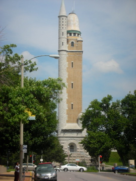
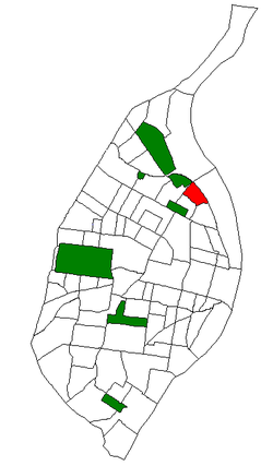
Compton Heights is a neighborhood of St. Louis, Missouri. It is bordered by Interstate 44 to the north, Nebraska Avenue to the east, Shenandoah Avenue to the south, and Grand Boulevard to the west. Compton Hill Reservoir Park, home to the landmark Compton Water Tower, lies within the neighborhood. Compton Heights was one of the country's earliest planned residential developments of the nineteenth century. Its 1889 layout adhered to a plan that viewed nature as a neighbor, rather than as an enemy to be subjugated by a rectilinear grid. This is seen today in the neighborhood's wide setbacks and curving streets that create remarkable vistas, punctuated by more than 200 homes of extraordinary and varied interest. The entire neighborhood is a national historic district.

<span class="mw-page-title-main">O'Fallon, St. Louis</span> Neighborhood of St. Louis in Missouri, United States

O'Fallon is a neighborhood of St. Louis, Missouri. The neighborhood is located on the north side of the City of St. Louis, nestled between O'Fallon Park and Fairground Park. It is bounded by West Florissant, Harris Avenue, Algernon Street and Adelaide on the north, Pope Avenue on the northwest, Kossuth and Natural Bridge Avenues on the south via Fair Avenue, Warne on the east, and Newstead on the west. The O'Fallon neighborhood is located in the 21st Ward which is currently represented by Alderman John Collins-Muhammad.

<span class="mw-page-title-main">Southwest Garden, St. Louis</span> Neighborhood of St. Louis in Missouri, United States

Southwest Garden is a neighborhood of St. Louis, Missouri, located south of The Hill and Forest Park Southeast, west of the Missouri Botanical Garden and Tower Grove Park, east of Lindenwood Park and Clifton Heights, and north of North Hampton.

<span class="mw-page-title-main">Tower Grove East, St. Louis</span> Neighborhood of St. Louis in Missouri, United States

Tower Grove East is a neighborhood of St. Louis, Missouri. The Tower Grove East neighborhood is bordered by Shenandoah Avenue to the north, Nebraska Avenue to the east, Gravois Avenue to the south, and south Grand Boulevard to the west.

<span class="mw-page-title-main">Roxbury High Fort</span> United States historic place

Roxbury High Fort is a historic fort site on Beech Glen Street at Fort Avenue in the Roxbury neighborhood of Boston, Massachusetts. The site now contains a small park and the Cochituate Standpipe, also known as Fort Hill Tower, built in 1869. The fort site was added to the National Register of Historic Places in 1973. The site inspired the name of the Fort Hill neighborhood, which surrounds the area of the High Fort.

<span class="mw-page-title-main">Compton Hill Reservoir Park</span> Public park in St Louis, Missouri

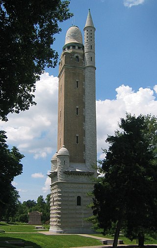
Compton Hill Reservoir Park is a 36-acre (15 ha) public park located in the Compton Heights neighborhood of St. Louis, Missouri, USA. Located on one of the highest elevations within the city, the park surrounds a 28-million-US-gallon (110,000 m3) reservoir used to provide water for many of the city's residents.

<span class="mw-page-title-main">Architecture of St. Louis</span>

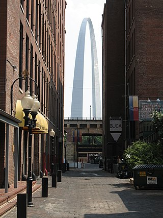
The architecture of St. Louis exhibits a variety of commercial, residential, and monumental architecture. St. Louis, Missouri is known for the Gateway Arch, the tallest monument constructed in the United States. Architectural influences reflected in the area include French Colonial, German, early American, European influenced, French Second Empire, Victorian, and modern architectural styles.

<span class="mw-page-title-main">O'Fallon Park</span>

O'Fallon Park is a municipal park in St. Louis, Missouri, that opened in 1908.

Number streets of St. Louis, Missouri, start at the Mississippi River and increase as they go west. They are primarily found Downtown and in Downtown West.

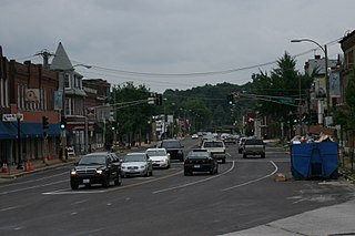
The streets of St. Louis, Missouri, United States, and the surrounding area of Greater St. Louis are under the jurisdiction of the City of St. Louis Street Department. According to the department's Streets Division, there are 1,000 miles (1,600 km) of streets and 600 miles (970 km) of alleys within the city.

<span class="mw-page-title-main">Grand Boulevard (St. Louis)</span>

Grand Boulevard is a major, seven to five-lane wide, north-south thoroughfare that runs through the center of St. Louis, Missouri. It runs north through Carondelet Park in the south portion of the city to the Mississippi River north of the McKinley Bridge, about midway between Forest Park and the Mississippi River. Neighborhoods that it runs through include Dutchtown, Tower Grove East, Tower Grove South, Compton Heights, Tiffany, Midtown, Jef-Vander-Lou, Fairground, and College Hill.

<span class="mw-page-title-main">Grand Avenue Water Tower</span> United States historic place

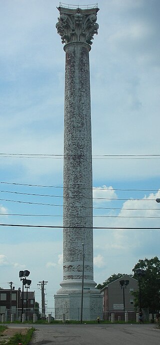
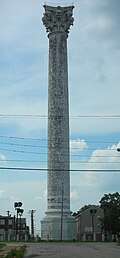
The Grand Avenue Water Tower is a water tower located at the intersection of Grand Blvd and 20th street in the College Hill neighborhood of St. Louis, Missouri. It is the oldest extant water tower in St. Louis, pre-dating both the Bissell Street Water Tower and the Compton Hill Water Tower.

<span class="mw-page-title-main">Bissell Street Water Tower</span> United States historic place

Bissell Street Water Tower is a historic standpipe water tower located at the junction of Bissell Street and Blair Avenue in St. Louis, Missouri. The tower was completed in 1886 and was in service until 1912. It is one of three remaining historic standpipes in Saint Louis, along with the Grand Avenue Water Tower and the Compton Hill Water Tower.

<span class="mw-page-title-main">St. Francis Xavier College Church</span> Historic church in Missouri, United States

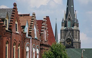
St. Francis Xavier College Church is a Catholic church in the Midtown neighborhood of St. Louis, Missouri, United States. The church was built by the Society of Jesus in 1836: the current building dates from 1884. It serves as a parish church in the Archdiocese of St. Louis and for the Saint Louis University community. It is a contributing property in the Midtown Historic District on the National Register of Historic Places and it is listed as a City Landmark in St. Louis.

References

  1. "2020 Census Neighborhood Results".
  2. "Neighborhood Development and Early History, 1836 – 1890" (PDF). Retrieved May 26, 2019.
  3. "Neighborhood Development and Early History, 1836 – 1890" (PDF). Retrieved May 26, 2019.
  4. "Early (Pre 1900) St. Louis Places of Worship".
  5. "Neighborhood Development and Early History, 1836 – 1890" (PDF). Retrieved May 26, 2019.
  6. 1 2 3 "College Hill - Some Historic Elements". Archived from the original on 2011-06-07.
  7. History American Buildings Survey: North Grand Water Tower, North Grand & 20th Streets, Saint Louis, Saint Louis City County (sic), MO
  8. 1 2 Harris, NiNi (January 1986). "Treasured Towers". In Hannon, Robert E. (ed.). St. Louis: Its Neighborhoods and Neighbors, Landmarks and Milestones. St. Louis, MO: Buxton & Skinner Printing Co.{{cite book}}: CS1 maint: date and year (link)
  9. History American Buildings Survey: Red Water Tower, Blair & Bissell Streets, Saint Louis, Saint Louis City County (sic), MO
  10. "College Hill Schools". Archived from the original on 2011-06-07.
  11. "College Hill Transit". Archived from the original on 2011-06-07.
  12. "Baden Neighborhood Statistics". St Louis, MO. Retrieved 26 January 2023.
  13. "Neighborhood Census Data". City of St. Louis. Retrieved 26 January 2023.
  14. City of St. Louis (PL 94-171)
  15. Kendizor, Sarah (August 19, 2015). "'We're surrounded by murders': a day in St Louis's most dangerous neighborhood". The Guardian. Archived from the original on 2015-08-19.

38°40′23″N90°12′35″W / 38.6730°N 90.2098°W / 38.6730; -90.2098