Colony of Niger

Last updated
Colony of Niger
Colonie du Niger (French)
1922–1960
Flag of France.svg
Anthem:  La Marseillaise
AOFMap1936.jpg
French West Africa in 1936. Note the Colonie du Niger, lacking the earlier Tibesti area of Chad, includes the later eastern Upper Volta
StatusConstituent of French West Africa
Capital Zinder
(1922–1926)
Niamey
(1926–1960)
Common languages French
Religion
Islam, Christianity
Government Colony
(1922–1946)
Overseas territory
(1946–1958)
Autonomous republic
(1958–1960)
Lieutenant Governor  
 1922–1929
Jules Brévié
 1958–1959
Louis Félix Rollet
High Commissioner  
 1959–1960
Jean Colombani
Prime Minister  
 1957–1958
Djibo Bakary
 1958–1960
Hamani Diori
History 
 Established
13 October 1922
 Status changed to overseas territory
13 October 1946
  Autonomy
19 December 1958
 Independence
3 August 1960
Area
1940 [1] 1,292,405 km2 (499,000 sq mi)
1948 [2] 1,218,994 km2 (470,656 sq mi)
Population
 1936 [2]
1,747,000
 1940 [1]
1,809,576
 1948 [2]
2,029,000
Currency French West African franc
(1922–1945)
CFA franc
(1945–1960)
ISO 3166 code NE
Preceded by
Succeeded by
Flag of France.svg Upper Senegal and Niger
First Republic of Niger (1960–1974) Flag of Niger.svg
Today part of Niger

The Colony of Niger (French : Colonie du Niger) was a French colonial possession covering much of the territory of the modern West African state of Niger, as well as portions of Mali, Burkina Faso and Chad. It existed in various forms from 1900 to 1960 but was titled the Colonie du Niger only from 1922 to 1960.

Contents

Military territory

While French took control of some of the areas of modern Niger began in the 1890s, a formal Zinder Military Territory was formed on 23 July 1900. This military territory only governed what is modern southern Niger, with only nominal rule east of Zinder or north of Tanout. Its Commandant was based at the village of Sorbo-Haoussa near Niamey, where the headquarters was moved in 1903. Administratively, it was part of the Senegambia and Niger Colony from 1902 to 1904 and Upper Senegal and Niger colony from 1904 to 1911. While commanded by officers of the French Troupes de marine, its budget and administration was dependent on the Lieutenant Governor at Kayes (latter Bamako), and military decision making—as well as contact with authorities in the Metropole or other colonies was through the Governor General in Dakar. [3] The area also appears on French maps as the "Third Military Territory". On 22 June 1910 the territory was renamed Niger Military Territory, and included parts of modern northeast Mali (Gao Cercle) and Northern Chad (Tibesti Cercle). On 21 June 1911 the Cercle of Gao ceded to French Sudan, and throughout the late nineteen-teens, efforts were made to establish permanent French posts in the north and east, in Bilma, N'guigmi and elsewhere. In 1911, the headquarters of the territory was moved to Zinder, reflecting both the relative peacefulness of the west of the territory, and the fear of incursion from the British to the South and the Italians from Libya. Despite this, French control of the northern and eastern areas remained minimal. Along with Mauritania, Niger remained the only part of French West Africa to remain under military rule.

Civilian colonial rule

On 13 October 1922 the civilian Colony of Niger took control of most of southern and western areas, with a lieutenant governor reporting to the Governor General of French West Africa. The 1919 creation of French Upper Volta as a civil colony removed the areas of modern Niger west of the Niger River. [4] In 1926, the capital was moved again to Niamey from Zinder. In 1930, Tibesti Cercle ceded to Chad Colony in French Equatorial Africa, and in 1932, the colony of French Upper Volta was divided amongst its neighbors, with the Cercles of Dori and Fada N'gourma ceded to Niger Colony.

World War II

Niger Colony officials, unlike neighboring Chad, remained loyal to the French Vichy government after 1940, and thus closed its southern border (to Nigeria) and eastern border until 1944.

Decolonization

On 31 December 1946 the Military Territories of N'Guigmi and Agadez were ceded to Niger Colony, leaving only Bilma Cercle as the last military-run section of modern Niger. This area in the far north east only came under French civilian administration in 1956.

In 1947, French Upper Volta was reconstituted, and the Cercles of Dori and Fada N'Gourma ceded to Upper Volta Colony. While there were minor border changes after 1947, the modern borders of Niger were roughly established with this change.

Following the 1956 Loi Cadre, rudiments of internal rule were created with the Territorial Assembly of Niger elected by popular vote, but holding only advisory and administrative powers. In 1958 the French Community succeed the French Union. On 25 August 1958 the Lieutenant Governor became High Commissioner of Niger, but remained Head of State of a quasi-independent state which controlled some purely internal administration.

The Constitution of 25 February 1959 was ratified by the Constituent Assembly of Niger, a body created for this purpose from the Territorial Assembly of Niger elected in December 1958. On 12 March 1959 the Constituent Assembly became the Legislative Assembly of Niger, with the head of government, Hamani Diori, retaining the title of President of the Council. Nominal executive powers were vested in the Assembly, with the constitution establishing elements, such as the flag of Niger, the national anthem of Niger and the coat of arms of Niger, along with language on naming of political bodies, rights and powers which have been retained in subsequent texts.

Following the Algerian War and the collapse of the French Fourth Republic, the colonies of the French Union became fully independent in 1960. Niger ratified its first fully independent constitution on 8 November 1960, and Jean Colombani stepped down as high commissioner on 10 November 1960.

See also

Notes

  1. 1 2 The Americana Annual 1946
  2. 1 2 3 Britannica Book Of The Year 1953
  3. Colin Newbury. The formation of the government general of French West Africa. Journal of African history, vol.1, no.1 (1960), pp.111–128.
  4. See the photo of the 1927 map at Don d’ouvrages aux Archives nationales Archived February 17, 2008, at the Wayback Machine from the French Embassy at Niamey, showing the outline of Niger colonie and military territories.

Related Research Articles

<span class="mw-page-title-main">French Sudan</span> French colonial territory in West Africa from 1880 to 1960; now Mali

French Sudan was a French colonial territory in the Federation of French West Africa from around 1880 until 1959, when it joined the Mali Federation, and then in 1960, when it became the independent state of Mali. The colony was formally called French Sudan from 1890 until 1899 and then again from 1921 until 1958, and had a variety of different names over the course of its existence. The colony was initially established largely as a military project led by French troops, but in the mid-1890s it came under civilian administration.

<span class="mw-page-title-main">French West Africa</span> Colonial federation from 1895 to 1958

French West Africa was a federation of eight French colonial territories in West Africa: Mauritania, Senegal, French Sudan, French Guinea, Ivory Coast, Upper Volta, Dahomey and Niger. The federation existed from 1895 until 1958. Its capital was Saint-Louis in Senegal until 1902, and then Dakar until the federation's collapse in 1960.

<span class="mw-page-title-main">Upper Senegal and Niger</span> French colony in West Africa (1904-21)

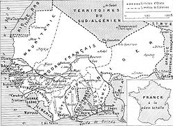
Upper Senegal and Niger was a colony in French West Africa, created on 21 October 1904 from colonial Senegambia and Niger by the decree "For the Reorganisation of the general government of French West Africa".

<span class="mw-page-title-main">Departments of Niger</span>

The regions of Niger are subdivided into 63 departments. Before the devolution program on 1999–2005, these departments were styled arrondissements. Confusingly, the next level up (regions) had, before 2002-2005 been styled departments. Prior to a revision in 2011, there had been 36 departments. A draft law in August 2011 would expand that number to 63. Until 2010, arrondissements remained a proposed subdivision of departments, though none were used. The decentralisation process, begun in the 1995-1999 period replaced appointed Prefects at Departmental or Arrondissement level with elected councils, first elected in 1999. These were the first local elections held in the history of Niger. Officials elected at commune level are then selected as representatives at Departmental, regional, and National level councils and administration. The Ministry of Decentralisation was created to oversee this task, and to create a national consultative council of local officials.

<span class="mw-page-title-main">Outline of Niger</span> Overview of and topical guide to Niger

The following outline is provided as an overview of and topical guide to Niger:

<span class="mw-page-title-main">Regions of Niger</span>

Niger is divided into eight regions, each of which is named after its capital.

<span class="mw-page-title-main">Téra Department</span> Department in Tillabéri Region, Niger

Téra is a department of the Tillabéri Region in Niger. Its capital lies at the city of Téra. As of 2011, the department had a total population of 579,658 people.

<span class="mw-page-title-main">Sawaba</span> Political party in Niger

The Union of Popular Forces for Democracy and Progress–Sawaba is a political party in Niger, founded as the Nigerien Democratic Union in 1954. The original party, founded by Nigerien Progressive Party (PPN) co-leader Djibo Bakary when he was expelled from the PPN. In the mid-1950s it created a broad coalition led by urban leftists but forged of conservative rural notables, especially from Hausa areas, which dominated the nascent Nigerien independence movement. In this period it was renamed Mouvement Socialiste Africain–Sawaba, and then simply Sawaba. In pushing for complete independence from France in a 1958 referendum, the party fractured. At independence in 1960 it found itself in opposition and outlawed by Niger's first president, Hamani Diori. From exile, the party attempted an abortive guerrilla campaign in the mid-1960s, and then largely disappeared. Its leadership returned to Niger following the 1974 military coup, but soon found themselves arrested, in exile, or marginalised. Following the return of democracy in 1991, the now elderly Bakary re-founded the party as UDFP–Sawaba. In the 1993 elections it took only a small numbers of votes. Within the year the party had split, with a new faction (UDFR–Sawaba) joining the government coalition. Despite Bakary's death in 1998 and their continued electoral underachievement, both parties holding the Sawaba name continue.

<span class="mw-page-title-main">Administrative divisions of Niger</span>

Niger is governed through a four layer, semi-decentralised series of administrative divisions. Begun 1992, and finally approved with the formation of the Fifth Republic of Niger on 18 July 1999, Niger has been enacting a plan for decentralisation of some state powers to local bodies. Prior to the 1999-2006 project, Niger's subdivisions were administered via direct appointment from the central government in Niamey. Beginning with Niger's first municipal elections of 2 February 1999, the nation started electing local officials for the first time. Citizens now elect local committee representatives in each commune, chosen by subdivisions of the commune: "quarters" in towns and "villages" in rural areas, with additional groupings for traditional polities and nomadic populations. These officials choose mayors, and from them are drawn representatives to the department level. The departmental council, prefect, and representatives to the regional level are chosen here using the same procedure. The system is repeated a regional level, with a regional prefect, council, and representatives to the High Council of Territorial Collectives. The HCCT has only advisory powers, but its members have some financial, planning, educational and environmental powers. The central government oversees this process through the office of the Minister of State for the Interior, Public Safety and Decentralization.

<span class="mw-page-title-main">France–Niger relations</span> Bilateral relations

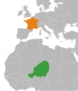
France–Niger relations are the foreign relations between France and Niger. Their relations are based on a long shared history and the more than sixty year rule of Niger by the French colonial empire, beginning with the French conquest in 1898. Niger obtained independence from France in 1960, and a history of French influenced culture and French language have been a point of commonality in the creation of a distinctive Nigerien culture from the diverse pre-colonial nationalities which make up modern Niger. France benefited economically from their time as a colonial power, and still relies on imports from Niger for elements of their economy.

<span class="mw-page-title-main">1946−47 Nigerien General Council election</span>

General Council elections were held in Niger on 15 December 1946, with a second round of voting on 5 January 1947. The General Council had been established by decree on 25 October 1946.

<span class="mw-page-title-main">Chad–Niger border</span> International border

The Chad–Niger border is 1,196 km in length and runs from the tripoint with Libya in the north, to the tripoint with Nigeria in the south.

<span class="mw-page-title-main">Mali–Niger border</span> International border

The Mali–Niger border is 828 km in length and runs from the tripoint with Burkina Faso in the west to the tripoint with Algeria in the east.

<span class="mw-page-title-main">Burkina Faso–Niger border</span> International border

The Burkina Faso–Niger border is 622 km in length and runs from the tripoint with Mali in the north to the tripoint with Benin in the south.

<span class="mw-page-title-main">Algeria–Niger border</span> International border

The Algeria–Niger border is 951 kilometres in length and runs from the tripoint with Mali in the west to the tripoint with Libya in the east.

<span class="mw-page-title-main">Libya–Niger border</span> International border

The Libya–Niger border is 342 kilometres in length and runs from the tripoint with Algeria in the west to the tripoint with Chad in the east.

<span class="mw-page-title-main">Ivory Coast–Mali border</span> International border

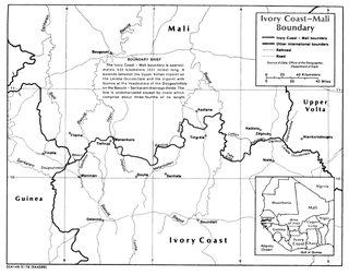
The Ivory Coast–Mali border is 599 km in length and runs from the tripoint with Guinea in the west to the tripoint with Burkina Faso in the east.

<span class="mw-page-title-main">Burkina Faso–Mali border</span> International border

The Burkina Faso–Mali border is 1,325 km in length and runs from the tripoint with Ivory Coast in the west to the tripoint with Niger in the east.

<span class="mw-page-title-main">Burkina Faso–Ivory Coast border</span> International border

The Burkina Faso–Ivory Coast border is 545 km in length and runs from the tripoint with Mali in the west to the tripoint with Ghana in the east.

Bibata Adamou Dakaou is a Nigerien former educator and politician. She was one of the first group of women elected to the National Assembly in 1989.

References