
The Flag of Niger

The following outline is provided as an overview of and topical guide to Niger:
Contents
- General reference
- Geography of Niger
- Location
- Environment of Niger
- Regions of Niger
- Demography of Niger
- Government and politics of Niger
- Branches of the government of Niger
- Foreign relations of Niger
- Law and order in Niger
- Military of Niger
- Local government in Niger
- History of Niger
- Culture of Niger
- Art in Niger
- Languages of Niger
- People of Niger
- Religion in Niger
- Sports in Niger
- Economy and infrastructure of Niger
- Education in Niger
- Health in Niger
- See also
- References
- External links
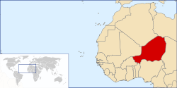
Niger – landlocked sovereign country located in West Africa. [1] It was named for the Niger River. It borders Nigeria and Benin to the south, Burkina Faso and Mali to the west, Algeria and Libya to the north and Chad to the east. The capital city is Niamey.


