Related Research Articles
Beaver Creek may refer to:
Beaver River may refer to:

Dawson Creek is a city in northeastern British Columbia, Canada. The municipality of 24.37 square kilometres (9.41 sq mi) had a population of 12,978 in 2016. Dawson Creek derives its name from the creek of the same name that runs through the community. The creek was named after George Mercer Dawson by a member of his land survey team when they passed through the area in August 1879. Once a small farming community, Dawson Creek became a regional centre after the western terminus of the Northern Alberta Railways was extended there in 1932. The community grew rapidly in 1942 as the US Army used the rail terminus as a transshipment point during construction of the Alaska Highway. In the 1950s, the city was connected to the interior of British Columbia via a highway and a railway through the Rocky Mountains. Since the 1960s, growth has slowed, but the area population has increased.

The Village of Pouce Coupe is a small town in northeastern British Columbia, Canada, and a member municipality of the Peace River Regional District. It was originally named 'Pouskapie's Prairie', after the name of the local native band chief. The 2.06-square-kilometre (0.80 sq mi) municipality is home to 792 residents.

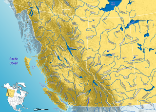
The Peace River is a 1,923-kilometre-long (1,195 mi) river in Canada that originates in the Rocky Mountains of northern British Columbia and flows to the northeast through northern Alberta. The Peace River joins the Athabasca River in the Peace-Athabasca Delta to form the Slave River, a tributary of the Mackenzie River. The Finlay River, the main headwater of the Peace River, is regarded as the ultimate source of the Mackenzie River. The combined Finlay–Peace–Slave–Mackenzie river system is the 13th longest river system in the world.

The Dane-zaa are an Athabaskan-speaking group of First Nations people. Their traditional territory is around the Peace River in Alberta and British Columbia, Canada. Today, about 1,600 Dane-zaa reside in British Columbia and an estimated half of them speak the Dane-zaa language. Approximately 2,000 Dane-zaa live in Alberta.

The Peace River Regional District is a regional district in northeastern British Columbia, Canada. The regional district comprises seven municipalities and four electoral areas. Its member municipalities are the cities of Fort St. John and Dawson Creek, the district municipalities of Tumbler Ridge, Chetwynd, Taylor, and Hudson's Hope, and the village of Pouce Coupe. The district's administrative offices are in Dawson Creek.

The Methow River is a tributary of the Columbia River in northern Washington in the United States. The river's 1,890-square-mile (4,900 km2) watershed drains the eastern North Cascades, with a population of about 5,000 people. The Methow's watershed is characterized by relatively pristine habitats, as much of the river basin is located in national forests and wildernesses. Many tributaries drain the large Pasayten Wilderness. An earlier economy based on agriculture is giving way to one based on recreation and tourism.

The Peace River Country is an aspen parkland region centring on the Peace River in Canada. It extends from northwestern Alberta to the Rocky Mountains in northeastern British Columbia, where a certain portion of the region is also referred to as the Peace River Block.
The Beatton River is a tributary of the Peace River, flowing generally east, then south through north-eastern British Columbia, Canada. The river rises at Pink Mountain, about 10 kilometres (6 mi) west of the Alaska Highway hamlet of the same name, and flows 240 kilometres (150 mi) generally east, then south, draining into the Peace River just downstream of Fort St. John. The river meanders mostly through the boreal forest and muskeg of the Peace Plain. Its major tributaries are the Doig and Blueberry Rivers.

The Hart Ranges are a major subrange of the Canadian Rockies located in northeastern British Columbia and western Alberta. The mountains constitute the southernmost portion of the Northern Rocky Mountains.
Petitot is a river in northern Alberta and British Columbia, Canada. It is a tributary of the Liard River.

The Pouce Coupe River is a major tributary of the Peace River in Alberta and British Columbia, Canada. Its name is officially spelled Pouce Coupé River, but it is commonly written without the acute accent.
The Schooler Creek Group is a stratigraphic unit of Middle to Late Triassic age in the Western Canadian Sedimentary Basin. It is present in northeastern British Columbia. It was named for Schooler Creek, a left tributary of Williston Lake, and was first described in two oil wells northwest of Fort St. John, by F.H. McLearn in 1921. Exposures along Williston Lake serve as a type locality in outcrop.
The Doig Formation is a geologic formation of middle Triassic age in the Western Canadian Sedimentary Basin. It takes the name from Doig River, a tributary of the Beatton River, and was first described in the Texaco N.F.A. Buick Creek No. 7 well by J.H. Armitage in 1962..
Grouard, also known as Grouard Mission, is a hamlet in northern Alberta within Big Lakes County. It was previously an incorporated municipality between 1909 and 1944.

The Redwillow River is a tributary of the Wapiti River in northern Alberta and north-eastern British Columbia, Canada. It flows through the Pouce Coupe Prairie, in the south of Peace River Country.
Dane-zaa, known in the language as Dane-zaa Ẕáágéʔ and once known as Beaver, is an Athabascan language of western Canada. It means "people-regular language." About one-tenth of the Dane-zaa people speak the language.
Toad Formation, Grayling Formation, and Toad-Grayling Formation are obsolete names for the strata of the Early to Middle Triassic Doig and Montney Formations. They were applied in the foothills and Rocky Mountains of northeastern British Columbia, on the western edge of the Western Canada Sedimentary Basin. Although the names are considered obsolete, their usage persists.
Lynx Creek, a creek in Arizona that feeds Lynx Lake
References
- ↑ Aboriginal Canada. "Doig River". Archived from the original on 2012-07-29. Retrieved 2009-03-20.
| Rivers |  | |
|---|---|---|
| Waterfalls | ||
| Lakes | ||
| Reservoirs | ||
| Glaciers | ||
| Other | ||