In the United States, a metropolitan statistical area (MSA) is a geographical region with a relatively high population density at its core and close economic ties throughout the region. Such regions are not legally incorporated as a city or town would be and are not legal administrative divisions like counties or separate entities such as states. As a result, sometimes the precise definition of a given metropolitan area will vary between sources. The statistical criteria for a standard metropolitan area were defined in 1949 and redefined as a metropolitan statistical area in 1983.

Coffee County is a county located in the southeastern part of the U.S. state of Alabama. As of the 2020 census, the population was 53,465. Its name is in honor of General John Coffee.

Dale County is a county located in the southeastern part of the U.S. state of Alabama. As of the 2020 census the population was 49,326. Its county seat and largest city is Ozark. Its name is in honor of General Samuel Dale.

Henry County is a county in the southeastern part of the U.S. state of Alabama. As of the 2020 census, its population was 17,146. Its county seat is Abbeville. The county was named for Patrick Henry (1736–1799), famous orator and Governor of Virginia.
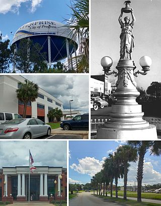
Enterprise is a city in the southeastern part of Coffee County and the southwestern part of Dale County in Southeastern Alabama, United States. Its population was 28,711 at the 2020 census. Enterprise is the primary city of the Enterprise micropolitan statistical area. It was originally a part of Enterprise–Ozark micropolitan area before being split; for a longer while it was originally part of the Dothan-Enterprise-Ozark combined statistical area but is now its own separate primary statistical area in later censuses.

Clayhatchee is a town in Dale County, Alabama, United States. At the 2010 census the population was 589, up from 501 in 2000. It was incorporated in April 1967. It is part of the Ozark Micropolitan Statistical Area.

Dothan( DOH-thən) is a city in and the county seat of Houston County in the U.S. state of Alabama. A slight portion of the city extends into Dale and Henry counties. It had a population of 71,072 at the 2020 census, making it Alabama's eighth-largest city by population and the 5th largest in Alabama by total area. It is near the state's southeastern corner, about 20 miles (32 km) west of Georgia and 16 miles (26 km) north of Florida. It is named after the biblical city where Joseph's brothers threw him into a cistern and sold him into slavery in Egypt.

Grimes is a town in Dale County, Alabama, United States. At the 2010 census the population was 558, up from 459 in 2000. It is part of the Enterprise–Ozark Micropolitan Statistical Area.

Ozark is a city in and the county seat of Dale County, Alabama. As of the 2010 census, the population of the city was 14,907.

The Louisville metropolitan area is the 43rd largest metropolitan statistical area (MSA) in the United States. It had a population of 1,395,855 in 2020 according to the latest official census, and its principal city is Louisville, Kentucky.
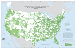
United States micropolitan statistical areas, as defined by the Office of Management and Budget (OMB), are labor market and statistical areas in the United States centered on an urban cluster with a population of at least 10,000 but fewer than 50,000 people. The micropolitan area designation was created in 2003. Like the better-known metropolitan statistical areas, a micropolitan area is a geographic entity used for statistical purposes based on counties and county equivalents. On July 21, 2023, the Office of Management and Budget released revised delineations of the various CBSAs in the United States, which recognized 542 micropolitan areas in the United States, four of which are in Puerto Rico.

The Nashville metropolitan area is a metropolitan statistical area in north-central Tennessee. Its principal city is Nashville, the capital of and largest city in Tennessee. With a population of over 2 million, it is the most populous metropolitan area in Tennessee. It is also the largest metropolitan area in Tennessee in terms of land area.

The United States Office of Management and Budget has defined the 12-county Denver–Aurora, CO Combined Statistical Area comprising the Denver–Aurora–Lakewood, CO Metropolitan Statistical Area, the Boulder, CO Metropolitan Statistical Area, and the Greeley, CO Metropolitan Statistical Area. The United States Census Bureau estimates that the population was 3,214,218 as of July 1, 2012, an increase of +3.99% since the 2010 United States Census, and ranking as the 16th most populous metropolitan combined statistical area and the 17th most populous primary statistical area of the United States. The population estimate for 2020 was 3,652,385.

The U.S. State of Alabama currently has 37 statistical areas that have been delineated by the Office of Management and Budget (OMB). On July 21, 2023, the OMB delineated 9 combined statistical areas, 15 metropolitan statistical areas, and 13 micropolitan statistical areas in Alabama.

The Knoxville metropolitan area, commonly known as Greater Knoxville, is a metropolitan statistical area (MSA) centered on Knoxville, Tennessee, the third largest city in Tennessee and the largest city in East Tennessee. It is the third largest metropolitan area in Tennessee. In 2020, the Knoxville metro area had a population of 879,773, and a population of 903,300 including Grainger County. The Knoxville–Morristown–Sevierville Combined Statistical Area (CSA) had a population of 1,156,861 according to the census bureau in 2020.

The Montgomery, Alabama Metropolitan Statistical Area is a metropolitan area in central Alabama. As of 2020, the MSA had a population of 386,047, ranking it 142nd among United States Metropolitan Statistical Areas. That number is up +3.07% from the 2010 census number of 374,536. In September of 2018 the OMB formed the Montgomery-Selma-Alexander City CSA. It's made up of the 4 county Montgomery MSA and the Selma, AL and Alexander City, AL micropolitan areas. The 7 county CSA has a population of 522,873 as of the 2020 census.
The Dothan–Enterprise–Ozark Combined Statistical Area was a CSA made up of five counties in the southeastern corner of the U.S. state of Alabama. The once statistical area includes one metropolitan area and originally one micropolitan area which then was split off as two. As of the 2010 census, the CSA had a population of 245,838. Currently an updated area called the Dothan-Ozark Combined Statistical area is used instead and Enterprise micropolitan area is now split as its own statistical area.

The Enterprise–Ozark Micropolitan Statistical Area, as defined by the United States Census Bureau, was an area consisting of two counties in southeastern Alabama, anchored by the cities of Enterprise and Ozark. As of the 2000 census, the μSA had a population of 92,744.

The La Crosse–Onalaska Metropolitan Statistical Area, as defined by the United States Census Bureau, is an area consisting of La Crosse County, Wisconsin and Houston County, Minnesota, anchored by the cities of La Crosse and Onalaska. The area is part of what is commonly referred to as the Coulee Region or 7 Rivers Region. As of the 2020 census, the MSA had a population of 139,627, and in 2022 estimates placed the total population at 139,094.

The Talladega-Sylacauga Micropolitan Statistical Area is a micropolitan statistical area that consisted of two counties in Alabama, anchored by the cities of Talladega and Sylacauga, as defined by the United States Census Bureau and the United States Office of Management and Budget. The area is also included in the Birmingham-Hoover-Talladega, Alabama Combined Statistical Area. As of the 2010 census, the μSA had a population of 93,830.

