East Rockhill Township, Bucks County, Pennsylvania

Last updated
East Rockhill Township
15090992247 bb9f62f10d k-1024x683.jpg
East Rockhill Seal.png
Bucks county - East Rockhill Township.png
Location of East Rockhill Township in Bucks County
USA Pennsylvania location map.svg
Red pog.svg
East Rockhill Township
Location in Pennsylvania and the United States
Usa edcp location map.svg
Red pog.svg
East Rockhill Township
East Rockhill Township (the United States)
Coordinates: 40°26′18″N75°16′16″W / 40.43833°N 75.27111°W / 40.43833; -75.27111
CountryUnited States
StatePennsylvania
County Bucks
Area
[1]
  Total13.09 sq mi (33.9 km2)
  Land12.91 sq mi (33.4 km2)
  Water0.18 sq mi (0.5 km2)
Elevation
446 ft (136 m)
Population
 (2010)
  Total5,706
  Estimate 
(2016) [2]
5,730
  Density440/sq mi (170/km2)
Time zone UTC-5 (EST)
  Summer (DST) UTC-4 (EDT)
Area codes 215, 267 and 445
FIPS code 42-017-21760
Website eastrockhilltownship.org

East Rockhill Township is a township in Bucks County, Pennsylvania, United States. The original Rockhill Township was established in 1740 and was divided into East and West Rockhill Townships in 1890. The population was 5,706 at the 2010 Census. East Rockhill is part of Pennridge School District. Pennridge Airport is located in East Rockhill Township.

Contents

History

The Levi Sheard Mill and Sheard's Mill Covered Bridge are listed on the National Register of Historic Places. [3] It was also the location of the formerly listed Mood's Covered Bridge.

Geography

According to the United States Census Bureau, the township has a total area of 13.1 square miles (34 km2), of which 12.9 square miles (33 km2) is land and 0.2 square miles (0.52 km2) (1.14%) is water. Tohickon Creek flows along the northern edge of the township into Lake Nockamixon at its northeastern edge and eastward into the Delaware River and drains most of East Rockhill. The southeastern side of the township is drained by the East Branch Perkiomen Creek into the Perkiomen Creek and Schuylkill River.

East Rockhill's villages include Hagersville, Rich Hill, Rockhill, Rockhill Station, Rock Ridge, Smoketown (also in West Rockhill), Sterners Mill, Weisel, and White Horse. [4]

Natural features include the East Branch Perkiomen Creek, Rock Hill, Three Mile Run, and Tohickon Creek. [4]

Adjacent municipalities

Demographics

Historical population
CensusPop.Note
1930 1,520
1940 1,350−11.2%
1950 1,62620.4%
1960 1,99022.4%
1970 2,86644.0%
1980 2,9713.7%
1990 3,75326.3%
2000 5,19938.5%
2010 5,7069.8%
2020 5,8192.0%
[5] [6]

As of the 2010 census, the township was 95.8% White, 0.7% Black or African American, 0.2% Native American, 0.6% Asian, and 1.2% were two or more races. 1.6% of the population were of Hispanic or Latino ancestry. [7]

As of the census [8] of 2000, there were 5,199 people, 1,828 households, and 1,427 families residing in the township. The population density was 401.5 inhabitants per square mile (155.0/km2). There were 1,883 housing units at an average density of 145.4 per square mile (56.1/km2). The racial makeup of the township was 97.19% White, 0.81% African American, 0.40% Native American, 0.38% Asian, 0.06% Pacific Islander, 0.19% from other races, and 0.96% from two or more races. Hispanic or Latino of any race were 1.25% of the population.

There were 1,828 households, out of which 40.4% had children under the age of 18 living with them, 68.6% were married couples living together, 5.8% had a female householder with no husband present, and 21.9% were non-families. 17.1% of all households were made up of individuals, and 5.4% had someone living alone who was 65 years of age or older. The average household size was 2.82 and the average family size was 3.21.

In the township the population was spread out, with 28.8% under the age of 18, 6.3% from 18 to 24, 32.5% from 25 to 44, 23.6% from 45 to 64, and 8.9% who were 65 years of age or older. The median age was 36 years. For every 100 females there were 102.1 males. For every 100 females age 18 and over, there were 101.0 males.

The median income for a household in the township was $59,663, and the median income for a family was $70,645. Males had a median income of $43,134 versus $30,473 for females. The per capita income for the township was $24,594. About 2.0% of families and 4.9% of the population were below the poverty line, including 3.0% of those under age 18 and 7.6% of those age 65 or over.

Transportation

PA 313 westbound and PA 563 northbound in East Rockhill Township 2022-09-30 16 41 53 View west along Pennsylvania State Route 313 and north along Pennsylvania State Route 563 (Dublin Pike) just northwest of East Rock Road in East Rockhill Township, Bucks County, Pennsylvania.jpg
PA 313 westbound and PA 563 northbound in East Rockhill Township

As of 2022 there were 48.33 miles (77.78 km) of public roads in East Rockhill Township, of which 11.19 miles (18.01 km) were maintained by the Pennsylvania Department of Transportation (PennDOT) and 37.14 miles (59.77 km) were maintained by the township. [9]

The main highways serving East Rockhill Township are Pennsylvania Route 313 and Pennsylvania Route 563. PA 313 follows a southeast-northwest alignment following Dublin Pike across northeastern portions of the township. PA 563 follows a north-south alignment utilizing Ridge Road, Dublin Pike and Mountain View Drive across the eastern portion of the township. The two highways have a concurrency along a portion of Dublin Pike.

Climate

According to the Köppen climate classification system, East Rockhill Twp has a Hot-summer, Humid continental climate (Dfa). Dfa climates are characterized by at least one month having an average mean temperature ≤ 32.0 °F (0.0 °C), at least four months with an average mean temperature ≥ 50.0 °F (10.0 °C), at least one month with an average mean temperature ≥ 71.6 °F (22.0 °C) and no significant precipitation difference between seasons. Although most summer days are slightly humid in East Rockhill Twp, episodes of heat and high humidity can occur with heat index values > 104 °F (40 °C). Since 1981, the highest air temperature was 101.5 °F (38.6 °C) on July 22, 2011, and the highest daily average mean dew point was 74.3 °F (23.5 °C) on August 12, 2016. The average wettest month is July, which corresponds with the annual peak in thunderstorm activity. Since 1981, the wettest calendar day was 6.73 inches (171 mm) on August 27, 2011. During the winter months, the average annual extreme minimum air temperature is −2.8 °F (−19.3 °C). [10] Since 1981, the coldest air temperature was −13.7 °F (−25.4 °C), on January 22, 1984. Episodes of extreme cold and wind can occur with wind chill values < −14 °F (−26 °C). The average annual snowfall (Nov-Apr) is between 30 inches (76 cm) and 36 inches (91 cm). Ice storms and large snowstorms depositing ≥ 12 inches (30 cm) of snow occur once every few years, particularly during nor’easters from December through February.

Climate data for East Rockhill Twp, Elevation 469 ft (143 m), 1981-2010 normals, extremes 1981-2018
MonthJanFebMarAprMayJunJulAugSepOctNovDecYear
Record high °F (°C)69.9
(21.1)
77.5
(25.3)
86.1
(30.1)
92.6
(33.7)
93.9
(34.4)
94.6
(34.8)
101.5
(38.6)
98.6
(37.0)
96.4
(35.8)
88.4
(31.3)
79.6
(26.4)
74.1
(23.4)
101.5
(38.6)
Average high °F (°C)37.8
(3.2)
41.2
(5.1)
49.7
(9.8)
61.9
(16.6)
71.9
(22.2)
80.4
(26.9)
84.4
(29.1)
82.8
(28.2)
76.0
(24.4)
64.5
(18.1)
53.4
(11.9)
41.9
(5.5)
62.3
(16.8)
Daily mean °F (°C)29.2
(−1.6)
31.9
(−0.1)
39.6
(4.2)
50.5
(10.3)
60.3
(15.7)
69.3
(20.7)
73.7
(23.2)
72.1
(22.3)
64.8
(18.2)
53.2
(11.8)
43.5
(6.4)
33.6
(0.9)
51.9
(11.1)
Average low °F (°C)20.5
(−6.4)
22.6
(−5.2)
29.5
(−1.4)
39.1
(3.9)
48.7
(9.3)
58.2
(14.6)
63.1
(17.3)
61.5
(16.4)
53.5
(11.9)
41.9
(5.5)
33.5
(0.8)
25.2
(−3.8)
41.5
(5.3)
Record low °F (°C)−13.7
(−25.4)
−6.1
(−21.2)
1.7
(−16.8)
15.9
(−8.9)
30.9
(−0.6)
39.7
(4.3)
46.0
(7.8)
40.8
(4.9)
33.7
(0.9)
22.7
(−5.2)
10.2
(−12.1)
−3.2
(−19.6)
−13.7
(−25.4)
Average precipitation inches (mm)3.50
(89)
2.85
(72)
3.81
(97)
4.12
(105)
4.33
(110)
4.38
(111)
4.80
(122)
3.90
(99)
4.54
(115)
4.34
(110)
3.76
(96)
4.05
(103)
48.38
(1,229)
Average relative humidity (%)68.465.460.959.563.669.569.772.372.971.770.470.767.9
Average dew point °F (°C)20.1
(−6.6)
21.6
(−5.8)
27.2
(−2.7)
36.9
(2.7)
47.9
(8.8)
58.9
(14.9)
63.2
(17.3)
62.7
(17.1)
55.9
(13.3)
44.3
(6.8)
34.5
(1.4)
25.1
(−3.8)
41.6
(5.3)
Source: PRISM [11]

Ecology

According to the A. W. Kuchler U.S. potential natural vegetation types, East Rockhill Twp would have a dominant vegetation type of Appalachian Oak (104) with a dominant vegetation form of Eastern Hardwood Forest (25). [12] The plant hardiness zone is 6b with an average annual extreme minimum air temperature of −2.8 °F (−19.3 °C). [10] The spring bloom typically begins by April 14 and fall color usually peaks by October 26.

See also

Related Research Articles

<span class="mw-page-title-main">Bedminster Township, Pennsylvania</span> Township in Pennsylvania, United States

Bedminster Township is a township in Bucks County, Pennsylvania, United States. The population was 6,574 at the 2010 census. It is part of the Delaware Valley metropolitan region. Bedminster is part of Pennridge School District.

<span class="mw-page-title-main">Bridgeton Township, Pennsylvania</span> Township in Pennsylvania, United States

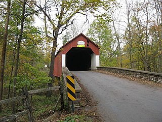
Bridgeton Township is a township in Bucks County, Pennsylvania, United States. The population was 1,277 at the 2010 census. The township was originally a part of adjacent Nockamixon Township, but a division was arranged and signed on May 24, 1890. This accord split an area of Nockamixon which ran west from the banks of the Delaware River to approximately one third the breadth of the original township. This smaller area was named "Bridgeton", since it was the site of Upper Black Eddy–Milford Bridge covered wooden truss bridge built in 1842, which connected the towns of Upper Black Eddy, Pennsylvania and Milford, New Jersey. The original covered bridge was replaced by a truss bridge in 1933.

<span class="mw-page-title-main">Bristol Township, Bucks County, Pennsylvania</span> Township in Pennsylvania, United States

Bristol Township is a township in Bucks County, Pennsylvania, United States. The population was 54,582 at the 2010 census, making it the 13th largest municipality in the state. Bristol Township, along with Bristol Borough, is a cultural hub for Lower Bucks County, hosting celebrations of African and Latino heritage. Parts of the township consist of the neighborhoods of Fairless Hills and Levittown. It is located within the Delaware Valley.

<span class="mw-page-title-main">Buckingham Township, Bucks County, Pennsylvania</span> Township in Pennsylvania, United States

Buckingham Township is a township in Bucks County, Pennsylvania, United States. The population was 20,075 at the 2010 census. Buckingham takes its name from Buckingham in Buckinghamshire, England. Buckingham Township was once known as Greenville and was once the historic county seat of the English Bucks County.

<span class="mw-page-title-main">Doylestown Township, Pennsylvania</span> Township in Pennsylvania, United States

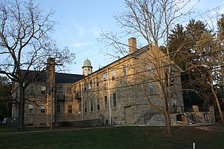
Doylestown Township is a township in Bucks County, Pennsylvania, United States. The population was 17,565 at the 2010 census. Adjacent to the county seat, the township hosts many county offices and the county correctional facility. Doylestown Central Park is a park in the township.

<span class="mw-page-title-main">Durham Township, Bucks County, Pennsylvania</span> Township in Pennsylvania, United States

Durham Township is a township in Bucks County, Pennsylvania, United States. The population was 1,144 at the 2010 census.

<span class="mw-page-title-main">Haycock Township, Bucks County, Pennsylvania</span> Township in Pennsylvania, United States

Haycock Township is a township in Bucks County, Pennsylvania, United States. The population was 2,225 at the 2010 census.

<span class="mw-page-title-main">Hilltown Township, Bucks County, Pennsylvania</span> Township in Pennsylvania, United States

Hilltown Township is a township in Bucks County, Pennsylvania, United States. The population was 15,029 at the 2010 census. Most of Hilltown is part of Pennridge School District, while a small portion in Line Lexington is part of North Penn School District.

<span class="mw-page-title-main">Lower Southampton Township, Pennsylvania</span> Township in Pennsylvania, United States

Lower Southampton Township is a township in Bucks County, Pennsylvania, United States. The population was 20,599 at the 2020 census.

<span class="mw-page-title-main">Milford Township, Bucks County, Pennsylvania</span> Township in Pennsylvania, United States

Milford Township is a township in Bucks County, Pennsylvania, United States. The population was 9,902 at the 2010 census. It is home to the Quakertown interchange of the Pennsylvania Turnpike Northeast Extension.

<span class="mw-page-title-main">Nockamixon Township, Pennsylvania</span> Township in Pennsylvania, United States

Nockamixon Township is a township in Bucks County, Pennsylvania, United States. The population was 3,441 at the 2010 census.

<span class="mw-page-title-main">Perkasie, Pennsylvania</span> Borough in Pennsylvania, United States

Perkasie is a borough in Bucks County, Pennsylvania, United States. Perkasie is 21.5 miles (34.6 km) southeast of Allentown and 39.2 miles (63.1 km) north of Philadelphia.

<span class="mw-page-title-main">Plumstead Township, Pennsylvania</span> Township in Pennsylvania, United States

Plumstead Township is a township in Bucks County, Pennsylvania, United States. The population was 12,442 at the 2010 census.

<span class="mw-page-title-main">Richland Township, Bucks County, Pennsylvania</span> Township in Pennsylvania, United States

Richland Township is a township in Bucks County, Pennsylvania, United States. The population was 11,100 at the 2010 census.

<span class="mw-page-title-main">Springfield Township, Bucks County, Pennsylvania</span> Township in Pennsylvania, United States

Springfield Township is a township in Bucks County, Pennsylvania, United States. The population was 5,035 at the 2010 census.

<span class="mw-page-title-main">Tinicum Township, Bucks County, Pennsylvania</span> Township in Pennsylvania, United States

Tinicum Township is a township in Bucks County, Pennsylvania, United States. The population was 3,995 at the 2010 census.

<span class="mw-page-title-main">Upper Southampton Township, Pennsylvania</span> Township in Pennsylvania, United States

Upper Southampton Township is a township in Bucks County, Pennsylvania, United States. The population was 15,152 at the 2010 census.

<span class="mw-page-title-main">West Rockhill Township, Pennsylvania</span> Township in Pennsylvania, United States

West Rockhill Township is a township in Bucks County, Pennsylvania, United States. The original Rockhill Township was established in 1740 and was divided into East Rockhill and West Rockhill Townships in 1890. The population was 5,256 at the 2010 census. West Rockhill Township is part of Pennridge School District.

<span class="mw-page-title-main">Smithfield Township, Monroe County, Pennsylvania</span> Place in Pennsylvania, United States

Smithfield Township is a township in Monroe County, Pennsylvania, United States. The population was 8,001 at the 2020 census.

<span class="mw-page-title-main">Marlborough Township, Pennsylvania</span> Township in Pennsylvania, United States

Marlborough Township is a township in Montgomery County, Pennsylvania, United States. The population was 3,178 at the 2010 census.

References

  1. "2016 U.S. Gazetteer Files". United States Census Bureau. Retrieved Aug 13, 2017.
  2. "Population and Housing Unit Estimates" . Retrieved June 9, 2017.
  3. "National Register Information System". National Register of Historic Places . National Park Service. July 9, 2010.
  4. 1 2 MacReynolds, George, Place Names in Bucks County, Pennsylvania, Doylestown, Bucks County Historical Society, Doylestown, PA, 1942, P1.
  5. "DVRPC > Site Search". Archived from the original on 2019-04-09. Retrieved 2017-01-31.
  6. "Census 2020".
  7. "Census 2010: Pennsylvania". Usatoday.Com. Retrieved 2013-07-22.
  8. "U.S. Census website". United States Census Bureau . Retrieved 2008-01-31.
  9. "East Rockhill Township map" (PDF). PennDOT. Retrieved March 11, 2023.
  10. 1 2 "USDA Interactive Plant Hardiness Map". United States Department of Agriculture . Retrieved October 22, 2019.
  11. "PRISM Climate Group, Oregon State University" . Retrieved October 22, 2019.
  12. "U.S. Potential Natural Vegetation, Original Kuchler Types, v2.0 (Spatially Adjusted to Correct Geometric Distortions)" . Retrieved October 22, 2019.