Hilltown Township, Bucks County, Pennsylvania

Last updated

Hilltown Township
Green Hills longwise BucksCo PA.jpg
Green Hills, home of Pearl Buck
Hilltown township seal.jpg
Bucks county - Hilltown Township.png
Location of Hilltown Township in Bucks County
USA Pennsylvania location map.svg
Red pog.svg
Hilltown Township
Location in Pennsylvania and the United States
Usa edcp location map.svg
Red pog.svg
Hilltown Township
Hilltown Township (the United States)
Coordinates: 40°22′36″N75°15′05″W / 40.37667°N 75.25139°W / 40.37667; -75.25139
CountryUnited States
StatePennsylvania
County Bucks
Area
[1]
  Total27.03 sq mi (70.0 km2)
  Land26.97 sq mi (69.9 km2)
  Water0.07 sq mi (0.2 km2)
Elevation
397 ft (121 m)
Population
 (2010)
  Total15,029
  Estimate 
(2016) [2]
15,243
  Density560/sq mi (210/km2)
Time zone UTC-5 (EST)
  Summer (DST) UTC-4 (EDT)
ZIP code
18927
Area codes 215, 267 and 445
FIPS code 42-017-34952
Website www.hilltown.org

Hilltown Township is a township in Bucks County, Pennsylvania, United States. The population was 15,029 at the 2010 census. Most of Hilltown is part of Pennridge School District, while a small portion in Line Lexington is part of North Penn School District.

Contents

History

The Uneek Havana Cigar Company at Blooming Glen and Green Hills Farm are listed on the National Register of Historic Places. Green Hills Farm is also designated a National Historic Landmark. [3] The Reuben and Elizabeth Strassburger Farmstead, owned by the Hilltown Historical Society is also listed on the National Register of Historic Places. It consists of three pre-Civil War buildings, each containing museum-like interiors.

Geography

According to the United States Census Bureau, the township has a total area of 26.9 square miles (70 km2), all land. It is located in the Delaware watershed and is drained by the East Branch Perkiomen Creek and Neshaminy Creek.

Its villages include Bean, Bethon, Blooming Glen, Deep Run, Fair Hill, Fricks, Griers Corner (also in Bedminster and Plumstead Townships,) Hilltown, Keystone Point, Kulps Corner (also in Bedminster Township), Leidytown, Line Lexington (also in New Britain Township and Montgomery County,) Loux Corner (Albrights Corner), Mount Pleasant, Naces Corner, New Galena, Pennville, Snoveltown, Thomas Corner, and Unionville (also in Montgomery County). [4]

Natural features in the township include Deep Run, Hardiaken Creek, Mill Creek, Perkiomen Creek (East Branch), and Pleasant Spring Creek. [4]

Neighboring municipalities

Hilltown Township surrounds the borough of Silverdale.

Demographics

Historical population
CensusPop.Note
1930 2,808
1940 3,18213.3%
1950 3,68815.9%
1960 5,54950.5%
1970 7,28131.2%
1980 9,32628.1%
1990 10,58213.5%
2000 12,10214.4%
2010 15,02924.2%
2020 16,2848.4%
[5] [6]

As of the 2010 census, the township was 92.7% White, 2.0% Black or African American, 0.1% Native American, 3.1% Asian, 0.1% Native Hawaiian, and 1.3% were two or more races. 2.8% of the population were of Hispanic or Latino ancestry. [7]

As of the census [8] of 2000, there were 12,102 people, 4,275 households, and 3,390 families residing in the township. The population density was 449.7 inhabitants per square mile (173.6/km2). There were 4,370 housing units at an average density of 162.4 per square mile (62.7/km2). The racial makeup of the township was 95.94% White, 1.54% African American, 0.09% Native American, 1.08% Asian, 0.02% Pacific Islander, 0.33% from other races, and 0.99% from two or more races. Hispanic or Latino of any race were 1.46% of the population.

There were 4,275 households, out of which 37.5% had children under the age of 18 living with them, 69.1% were married couples living together, 7.0% had a female householder with no husband present, and 20.7% were non-families. 16.4% of all households were made up of individuals, and 6.8% had someone living alone who was 65 years of age or older. The average household size was 2.81 and the average family size was 3.17.

In the township the population was spread out, with 27.2% under the age of 18, 6.1% from 18 to 24, 30.6% from 25 to 44, 24.1% from 45 to 64, and 12.1% who were 65 years of age or older. The median age was 37 years. For every 100 females, there were 97.5 males. For every 100 females age 18 and over, there were 94.4 males.

The median income for a household in the township was $63,178, and the median income for a family was $69,183. Males had a median income of $46,145 versus $30,566 for females. The per capita income for the township was $25,800. About 3.3% of families and 4.1% of the population were below the poverty line, including 4.8% of those under age 18 and 3.6% of those age 65 or over.

Transportation

PA 309 southbound in Hilltown Township 2022-10-14 12 40 37 View south along Pennsylvania State Route 309 (Sellersville Bypass) from the overpass for Fairhill Road in Hilltown Township, Bucks County, Pennsylvania.jpg
PA 309 southbound in Hilltown Township

As of 2022 there were 135.75 miles (218.47 km) of public roads in Hilltown Township, of which 45.31 miles (72.92 km) were maintained by the Pennsylvania Department of Transportation (PennDOT) and 90.44 miles (145.55 km) were maintained by the township. [9]

Pennsylvania Route 309 is the most prominent highway serving Hilltown Township. It follows the Sellersville Bypass on a southeast-to-northwest alignment through the southwestern portion of the township. Pennsylvania Route 113 follows Souderton Road along a southwest-to-northeast alignment through northern and western sections of the township. Pennsylvania Route 152 follows a southeast-to-northwest alignment utilizing several roads across the central portion of the township. Finally, Pennsylvania Route 313 follows a southeast-to-northwest alignment mostly along Dublin Pike along the northeastern edge of the township.

The southwestern portion of Hilltown Township is served by SEPTA bus Route 132, which runs between the Montgomery Mall and Telford. [10]

Climate

According to the Köppen climate classification system, Hilltown Twp has a Hot-summer, Humid continental climate (Dfa). Dfa climates are characterized by at least one month having an average mean temperature ≤ 32.0 °F (0.0 °C), at least four months with an average mean temperature ≥ 50.0 °F (10.0 °C), at least one month with an average mean temperature ≥ 71.6 °F (22.0 °C) and no significant precipitation difference between seasons. Although most summer days are slightly humid in Hilltown Twp, episodes of heat and high humidity can occur with heat index values > 104 °F (40 °C). Since 1981, the highest air temperature was 101.3 °F (38.5 °C) on 07/22/2011, and the highest daily average mean dew point was 74.0 °F (23.3 °C) on 08/12/2016. The average wettest month is July which corresponds with the annual peak in thunderstorm activity. Since 1981, the wettest calendar day was 6.66 inches (169 mm) on 08/27/2011. During the winter months, the average annual extreme minimum air temperature is −3.1 °F (−19.5 °C). [11] Since 1981, the coldest air temperature was −13.5 °F (−25.3 °C) on 01/22/1984. Episodes of extreme cold and wind can occur with wind chill values < −14 °F (−26 °C). The average annual snowfall (Nov-Apr) is between 30 inches (76 cm) and 36 inches (91 cm). Ice storms and large snowstorms depositing ≥ 12 inches (30 cm) of snow occur once every few years, particularly during nor’easters from December through February.

Climate data for Hilltown Twp, Elevation 561 ft (171 m), 1981-2010 normals, extremes 1981-2018
MonthJanFebMarAprMayJunJulAugSepOctNovDecYear
Record high °F (°C)69.9
(21.1)
77.2
(25.1)
85.6
(29.8)
92.6
(33.7)
93.6
(34.2)
94.4
(34.7)
101.3
(38.5)
98.5
(36.9)
96.2
(35.7)
87.9
(31.1)
79.7
(26.5)
74.3
(23.5)
101.3
(38.5)
Average high °F (°C)37.7
(3.2)
41.1
(5.1)
49.4
(9.7)
61.8
(16.6)
71.6
(22.0)
80.1
(26.7)
84.1
(28.9)
82.5
(28.1)
75.7
(24.3)
64.3
(17.9)
53.3
(11.8)
41.9
(5.5)
62.1
(16.7)
Daily mean °F (°C)28.9
(−1.7)
31.7
(−0.2)
39.3
(4.1)
50.3
(10.2)
60.0
(15.6)
69.0
(20.6)
73.5
(23.1)
71.9
(22.2)
64.5
(18.1)
53.2
(11.8)
43.4
(6.3)
33.4
(0.8)
51.7
(10.9)
Average low °F (°C)20.2
(−6.6)
22.3
(−5.4)
29.2
(−1.6)
38.8
(3.8)
48.5
(9.2)
57.9
(14.4)
62.8
(17.1)
61.3
(16.3)
53.4
(11.9)
42.0
(5.6)
33.5
(0.8)
24.9
(−3.9)
41.3
(5.2)
Record low °F (°C)−13.5
(−25.3)
−5.9
(−21.1)
1.4
(−17.0)
15.6
(−9.1)
30.4
(−0.9)
39.5
(4.2)
46.0
(7.8)
40.7
(4.8)
33.6
(0.9)
22.5
(−5.3)
10.0
(−12.2)
−3.7
(−19.8)
−13.5
(−25.3)
Average precipitation inches (mm)3.42
(87)
2.79
(71)
3.86
(98)
4.06
(103)
4.37
(111)
4.40
(112)
4.84
(123)
3.97
(101)
4.57
(116)
4.27
(108)
3.74
(95)
3.98
(101)
48.27
(1,226)
Average relative humidity (%)68.465.160.859.063.569.769.572.073.471.470.470.467.8
Average dew point °F (°C)19.8
(−6.8)
21.3
(−5.9)
26.9
(−2.8)
36.5
(2.5)
47.6
(8.7)
58.7
(14.8)
62.9
(17.2)
62.4
(16.9)
55.8
(13.2)
44.2
(6.8)
34.4
(1.3)
24.8
(−4.0)
41.4
(5.2)
Source: PRISM [12]

Ecology

According to the A. W. Kuchler U.S. potential natural vegetation types, Hilltown Twp would have a dominant vegetation type of Appalachian Oak (104) with a dominant vegetation form of Eastern Hardwood Forest (25). [13] The plant hardiness zone is 6b with an average annual extreme minimum air temperature of −3.1 °F (−19.5 °C). [11] The spring bloom typically begins by April 15 and fall color usually peaks by October 26.

Related Research Articles

<span class="mw-page-title-main">Bedminster Township, Pennsylvania</span> Township in Pennsylvania, United States

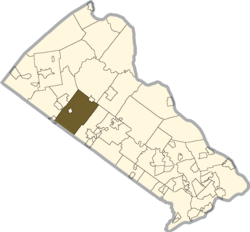
Bedminster Township is a township in Bucks County, Pennsylvania, United States. The population was 6,574 at the 2010 census. It is part of the Delaware Valley metropolitan region. Bedminster is part of Pennridge School District.

<span class="mw-page-title-main">Bridgeton Township, Pennsylvania</span> Township in Pennsylvania, United States

Bridgeton Township is a township in Bucks County, Pennsylvania, United States. The population was 1,277 at the 2010 census. The township was originally a part of adjacent Nockamixon Township, but a division was arranged and signed on May 24, 1890. This accord split an area of Nockamixon which ran west from the banks of the Delaware River to approximately one third the breadth of the original township. This smaller area was named "Bridgeton", since it was the site of Upper Black Eddy–Milford Bridge covered wooden truss bridge built in 1842, which connected the towns of Upper Black Eddy, Pennsylvania and Milford, New Jersey. The original covered bridge was replaced by a truss bridge in 1933.

<span class="mw-page-title-main">Buckingham Township, Bucks County, Pennsylvania</span> Township in Pennsylvania, United States

Buckingham Township is a township in Bucks County, Pennsylvania, United States. The population was 20,075 at the 2010 census. Buckingham takes its name from Buckingham in Buckinghamshire, England. Buckingham Township was once known as Greenville and was once the historic county seat of the English Bucks County.

<span class="mw-page-title-main">Doylestown Township, Pennsylvania</span> Township in Pennsylvania, United States

Doylestown Township is a township in Bucks County, Pennsylvania, United States. The population was 17,565 at the 2010 census. Adjacent to the county seat, the township hosts many county offices and the county correctional facility. Doylestown Central Park is a park in the township.

<span class="mw-page-title-main">Dublin, Pennsylvania</span> Borough in Pennsylvania, United States

Dublin is a borough in Bucks County, Pennsylvania, United States. The population was 2,158 at the 2010 census. Dublin is part of Pennridge School District.

<span class="mw-page-title-main">Durham Township, Bucks County, Pennsylvania</span> Township in Pennsylvania, United States

Durham Township is a township in Bucks County, Pennsylvania, United States. The population was 1,144 at the 2010 census.

<span class="mw-page-title-main">East Rockhill Township, Bucks County, Pennsylvania</span> Township in Pennsylvania, United States

East Rockhill Township is a township in Bucks County, Pennsylvania, United States. The original Rockhill Township was established in 1740 and was divided into East and West Rockhill Townships in 1890. The population was 5,706 at the 2010 Census. East Rockhill is part of Pennridge School District. Pennridge Airport is located in East Rockhill Township.

<span class="mw-page-title-main">Haycock Township, Bucks County, Pennsylvania</span> Township in Pennsylvania, United States

Haycock Township is a township in Bucks County, Pennsylvania, United States. The population was 2,225 at the 2010 census.

<span class="mw-page-title-main">Lower Southampton Township, Pennsylvania</span> Township in Pennsylvania, United States

Lower Southampton Township is a township in Bucks County, Pennsylvania, United States. The population was 20,599 at the 2020 census.

<span class="mw-page-title-main">Middletown Township, Bucks County, Pennsylvania</span> Place in Pennsylvania, United States

Middletown Township is a township in Bucks County, Pennsylvania, United States. The population was 46,040 at the 2020 census. Many sections of Levittown are located in the southern end of the township. The municipality surrounds the boroughs of Langhorne, Langhorne Manor, Penndel and Hulmeville; much of the township beyond Levittown uses Langhorne as a mailing address. It is located within the Delaware Valley.

<span class="mw-page-title-main">Milford Township, Bucks County, Pennsylvania</span> Township in Pennsylvania, United States

Milford Township is a township in Bucks County, Pennsylvania, United States. The population was 9,902 at the 2010 census. It is home to the Quakertown interchange of the Pennsylvania Turnpike Northeast Extension.

<span class="mw-page-title-main">New Britain Township, Pennsylvania</span> Township in Pennsylvania, United States

New Britain Township is a township in Bucks County, Pennsylvania, United States. The population was 11,070 at the 2010 census.

<span class="mw-page-title-main">Newtown Township, Bucks County, Pennsylvania</span> Township in Pennsylvania, United States

Newtown Township is a township in Bucks County, Pennsylvania, United States. The population was 19,299 at the 2010 census.

<span class="mw-page-title-main">Perkasie, Pennsylvania</span> Borough in Pennsylvania, United States

Perkasie is a borough in Bucks County, Pennsylvania, United States. Perkasie is 21.5 miles (34.6 km) southeast of Allentown and 39.2 miles (63.1 km) north of Philadelphia.

<span class="mw-page-title-main">Plumstead Township, Pennsylvania</span> Township in Pennsylvania, United States

Plumstead Township is a township in Bucks County, Pennsylvania, United States. The population was 12,442 at the 2010 census.

<span class="mw-page-title-main">Tinicum Township, Bucks County, Pennsylvania</span> Township in Pennsylvania, United States

Tinicum Township is a township in Bucks County, Pennsylvania, United States. The population was 3,995 at the 2010 census.

<span class="mw-page-title-main">Upper Southampton Township, Pennsylvania</span> Township in Pennsylvania, United States

Upper Southampton Township is a township in Bucks County, Pennsylvania, United States. The population was 15,152 at the 2010 census.

<span class="mw-page-title-main">Warrington Township, Bucks County, Pennsylvania</span> Township in Pennsylvania, United States

Warrington Township is a township in Bucks County, Pennsylvania, United States. Warrington Township is a northern suburb of Philadelphia. The population was 25,639 at the 2020 census.

<span class="mw-page-title-main">West Rockhill Township, Pennsylvania</span> Township in Pennsylvania, United States

West Rockhill Township is a township in Bucks County, Pennsylvania, United States. The original Rockhill Township was established in 1740 and was divided into East Rockhill and West Rockhill Townships in 1890. The population was 5,256 at the 2010 census. West Rockhill Township is part of Pennridge School District.

<span class="mw-page-title-main">Franconia Township, Montgomery County, Pennsylvania</span> Township in Pennsylvania, United States

Franconia Township is a township in Montgomery County, Pennsylvania, United States. The population was 13,064 at the 2010 census.

References

  1. "2016 U.S. Gazetteer Files". United States Census Bureau. Retrieved August 13, 2017.
  2. "Population and Housing Unit Estimates" . Retrieved June 9, 2017.
  3. "National Register Information System". National Register of Historic Places . National Park Service. July 9, 2010.
  4. 1 2 MacReynolds, George, Place Names in Bucks County, Pennsylvania, Doylestown, Bucks County Historical Society, Doylestown, PA, 1942, P1.
  5. "DVRPC > Site Search". Archived from the original on April 9, 2019. Retrieved March 21, 2014.
  6. "Census 2020".
  7. "Census 2010: Philadelphia gains, Pittsburgh shrinks in population". USA Today . Archived from the original on March 14, 2011.
  8. "U.S. Census website". United States Census Bureau . Retrieved January 31, 2008.
  9. "Hilltown Township map" (PDF). PennDOT. Retrieved March 11, 2023.
  10. SEPTA Official Transit & Street Map Suburban (PDF) (Map). SEPTA. Retrieved May 2, 2016.
  11. 1 2 "USDA Interactive Plant Hardiness Map". United States Department of Agriculture . Retrieved October 25, 2019.
  12. "PRISM Climate Group, Oregon State University" . Retrieved October 25, 2019.
  13. "U.S. Potential Natural Vegetation, Original Kuchler Types, v2.0 (Spatially Adjusted to Correct Geometric Distortions)" . Retrieved October 25, 2019.