Fairburn, Georgia

Last updated

Fairburn, Georgia
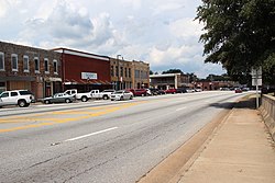
US Route 29 in Fairburn, Georgia.JPG
Downtown Fairburn
Flag of Fairburn, Georgia.png
Seal of Fairburn, Georgia.png
Fulton County Georgia Municipalities Map Fairburn Highlighted.svg
Location in Fulton County and the state of Georgia
Metro atlanta.jpg
Red pog.svg
Fairburn
Coordinates: 33°32′59″N84°35′29″W / 33.54972°N 84.59139°W / 33.54972; -84.59139 [1]
Country United States
State Georgia
County Fulton
Government
  Type Mayor–council government
  MayorMario Avery [2]
  City AdministratorTony Phillips [3]
Area
[4]
  Total17.12 sq mi (44.34 km2)
  Land16.91 sq mi (43.79 km2)
  Water0.21 sq mi (0.55 km2)
Elevation
[1]
1,027 ft (313 m)
Population
 (2020)
  Total16,483
  Density974.86/sq mi (376.40/km2)
   Demonym
Fairburnite
Time zone UTC-5 (Eastern (EST))
  Summer (DST) UTC-4 (EDT)
ZIP code
30213
Area code 770
FIPS code 13-28380 [5]
GNIS feature ID2403586 [1]
Website www.fairburn.com

Fairburn is a city in Fulton County, Georgia, United States, with a population of 16,483, according to the 2020 census. [6] Though it has a rich history of its own, the city is now a closely linked suburb of Atlanta, which lies just 17 miles to the north.

Contents

Name

The community is named after Fairburn, in England. [7]

History

Fairburn is located along a railroad line and was the county seat of Campbell County starting in 1871. It was chosen as county seat in a referendum in 1871 that was spurred by the original seat of Campbellton refusing to allow the Atlanta and West Point Railroad line through on account of the anticipated noise in the 1850s. The railroad instead passed through Fairburn. Campbellton then faded away as Fairburn grew. The government of Campbell County went bankrupt in 1931 during the Great Depression and, along with Milton County to the north, was absorbed into Fulton County when 1932 began. Fairburn's population was 305 in 1870, with 208 white and 97 black residents. [8]

Geography

Fairburn is located along Interstate 85, which leads northeast 20 miles (32 km) to downtown Atlanta and southwest 142 miles (229 km) to Montgomery, Alabama. Georgia State Route 74 also runs through the city, leading south 13 miles (21 km) to Peachtree City. Some areas in nearby Fayette County have a Fairburn mailing address.

According to the 2010 census, the city has a total area of 17.1 square miles (44.3 km2), of which 16.9 square miles (43.8 km2) is land and 0.2 square miles (0.5 km2), or 1.24%, is water. [9]

Demographics

Historical population
CensusPop.Note
1860 298
1870 3052.3%
1880 56384.6%
1890 69523.4%
1900 7619.5%
1910 1,39583.3%
1920 1,60014.7%
1930 1,372−14.2%
1940 1,5029.5%
1950 1,88925.8%
1960 2,47030.8%
1970 3,14327.2%
1980 3,46610.3%
1990 4,01315.8%
2000 5,46436.2%
2010 12,950137.0%
2020 16,48327.3%
U.S. Decennial Census [10]
Fairburn racial composition as of 2020 [11]
RaceNum.Perc.
White (non-Hispanic)1,5409.34%
Black or African American (non-Hispanic)12,60176.45%
Native American 160.1%
Asian 2201.33%
Pacific Islander 40.02%
Other/Mixed 4542.75%
Hispanic or Latino 1,64810.0%

As of the 2020 United States census, there were 16,483 people, 5,051 households, and 3,442 families residing in the city.

Education

Culture

Fairburn is home to the Georgia Renaissance Festival, in operation during the springtime. The city of Fairburn hosts the "Fairburn Festival" each fall, featuring a parade, local food and crafts vendors and musical performances.[ citation needed ]

Related Research Articles

<span class="mw-page-title-main">Fulton County, Georgia</span> County in Georgia, United States

Fulton County is a county in the north-central portion of the U.S. state of Georgia. As of the 2020 United States census, the population was 1,066,710, making it the state's most populous county. Its county seat and most populous city is Atlanta, the state capital. About 90% of the city of Atlanta is within Fulton County; the remaining portion is in DeKalb County. Fulton County is part of the Atlanta–Sandy Springs–Roswell metropolitan statistical area.

<span class="mw-page-title-main">Douglas County, Georgia</span> County in Georgia, United States

Douglas County is a county located in the north central portion of the U.S. state of Georgia. As of the 2020 U.S. Census, the population was 144,237, having more than doubled since 1990. The county seat is Douglasville. The city of Villa Rica, and a small portion of Austell are both also located in Douglas County. Douglas County is included in Metro Atlanta. It has attracted new residents as jobs have increased in the Atlanta area.

<span class="mw-page-title-main">Cherokee County, Georgia</span> County in Georgia, United States

Cherokee County is located in the US state of Georgia. As of the 2020 Census, the population was 266,620. The county seat is Canton. The county Board of Commissioners is the governing body, with members elected to office. Cherokee County is included in the Atlanta Metropolitan Area.

<span class="mw-page-title-main">Campbellton, Florida</span> Town in Florida, United States

Campbellton is a town in Jackson County, Florida, United States. The town is part of the Florida Panhandle in North Florida, and has a predominately African American majority. The population was 191 at the 2020 census.

<span class="mw-page-title-main">Alma, Georgia</span> City in Georgia, United States

Alma is a city in Bacon County, Georgia, United States, and the county seat. As of the 2020 census, the city had a population of 3,433.

<span class="mw-page-title-main">Winder, Georgia</span> City in Georgia, United States

Winder is a city and the county seat of Barrow County, Georgia, United States. It is located east of Atlanta and is part of the Atlanta metropolitan area. The population was 18,338 at the 2020 census.

<span class="mw-page-title-main">Jackson, Georgia</span> City in Georgia, United States

Jackson is a city in and the county seat of Butts County, Georgia, United States. The population was 5,045 in 2010, up from 3,934 at the 2000 census. In 2020, its population was 5,557. The community was named after governor James Jackson.

<span class="mw-page-title-main">Temple, Georgia</span> City in Georgia, United States

Temple is a city in Carroll and Haralson counties in the U.S. state of Georgia. The population was 5,089 at the 2020 census, up from 4,228 in 2010, a 20.36% increase.

<span class="mw-page-title-main">Douglasville, Georgia</span> City in Georgia, United States

The city of Douglasville is the county seat of and largest city in Douglas County, Georgia, United States. As of the 2020 census, the city had a population of 34,650, up from 30,961 in 2010 and 20,065 in 2000.

<span class="mw-page-title-main">Swainsboro, Georgia</span> City in Georgia, United States

Swainsboro is a city in Emanuel County, Georgia, United States. As of the 2020 census, the city had a population of 7,425. The city is the county seat of Emanuel County.

<span class="mw-page-title-main">Blue Ridge, Georgia</span> City in Georgia, United States

Blue Ridge is a city in Fannin County, Georgia, United States. As of the 2020 census, the city had a population of 1,253. The city is the county seat of Fannin County and the largest city in the county as well.

<span class="mw-page-title-main">Tyrone, Georgia</span> Town in Georgia, United States

Tyrone is a town in Fayette County, Georgia, United States. The population was 7,658 in 2020. The estimated population in 2018 was 7,388. It is a part of the Atlanta metropolitan area.

<span class="mw-page-title-main">East Point, Georgia</span> City in Georgia, United States

East Point is a suburban city located southwest of Atlanta in Fulton County, Georgia, United States. As of the 2020 census, the city had a population of 38,358. The city name is derived from being at the opposite end of the former Atlanta and West Point Railroad from West Point.

<span class="mw-page-title-main">Union City, Georgia</span> City in Georgia, United States

Union City is a city in Fulton County, Georgia, United States. The population was 26,830 at the 2020 census.

<span class="mw-page-title-main">Suwanee, Georgia</span> City in the United States

Suwanee is a city in Gwinnett County and a part of the Atlanta metropolitan area in the U.S. state of Georgia. As of the 2010 census, the population was 15,355; this had grown to an estimated 20,907 as of 2019. In 2020, its population was 20,786.

<span class="mw-page-title-main">West Point, Georgia</span> City in Georgia, United States

West Point is a city in Troup and Harris counties in the U.S. state of Georgia. It is located approximately halfway between Montgomery, Alabama and Atlanta along Interstate 85. As of 2020, its population was 3,719. Most of the city is in Troup County, which is part of the LaGrange micropolitan statistical area, and hence part of the Atlanta-Athens-Clarke County-Sandy Springs, GA combined statistical area. A sliver in the south is in Harris County, which is part of the Columbus metropolitan statistical area.

<span class="mw-page-title-main">Hampton, Georgia</span> City in Georgia, United States

Hampton is a city in southwestern Henry County, Georgia, United States. The population as of the 2020 census was 8,368. It is a southeastern suburb in the Atlanta metropolitan area.

<span class="mw-page-title-main">Greenville, Georgia</span> City in Georgia, United States

Greenville is a city and the county seat of Meriwether County, Georgia, United States. The population was 794 at the 2020 census, down from 876 in 2010. The city is located 60 miles (97 km) southwest of Atlanta and is part of the Atlanta metropolitan area.

<span class="mw-page-title-main">Manchester, Georgia</span> City in Georgia, United States

Manchester is a town in Meriwether and Talbot counties in the U.S. state of Georgia, although primarily in Meriwether. The population was 3,584 at the 2020 census, down from 4,230 in 2010. It is the most populous community in Meriwether County. CSX Transportation runs a railroad yard in Manchester.

<span class="mw-page-title-main">Chattahoochee Hills, Georgia</span> City in Georgia, United States

Chattahoochee Hills is a city in southern Fulton County, Georgia, United States. It is the incorporated part of a region called "Chattahoochee Hill Country", an area encompassing approximately 60,000 acres (240 km2) southwest of Atlanta, bordered on the northwest side by the Chattahoochee River.

References

  1. 1 2 3 U.S. Geological Survey Geographic Names Information System: Fairburn, Georgia
  2. Fairburn official web site. Retrieved September 29, 2018.
  3. Fairburn official web site. Retrieved January 27, 2020.
  4. "2020 U.S. Gazetteer Files". United States Census Bureau. Retrieved December 18, 2021.
  5. "U.S. Census website". United States Census Bureau . Retrieved January 31, 2008.
  6. "Race, Hispanic or Latino, Age, and Housing Occupancy: 2010 Census Redistricting Data (Public Law 94-171) Summary File (QT-PL), Fairburn city, Georgia". United States Census Bureau . Retrieved October 28, 2011.
  7. Krakow, Kenneth K. (1975). Georgia Place-Names: Their History and Origins (PDF). Macon, GA: Winship Press. p. 76. ISBN   0-915430-00-2.
  8. "Fairburn" . Retrieved November 19, 2023.
  9. "Geographic Identifiers: 2010 Demographic Profile Data (G001), Fairburn city, Georgia". United States Census Bureau . Retrieved October 28, 2011.
  10. "Census of Population and Housing". Census.gov. Retrieved June 4, 2015.
  11. "Explore Census Data". data.census.gov. Retrieved December 13, 2021.
  12. "Fairburn Branch." Atlanta-Fulton Public Library System. Retrieved on February 24, 2010.