Financial Historic District | |
Location | Original boundary: 15th Street, from Pennsylvania Avenue to I Street NW, Boundary increase: K Street, 14th & G Streets NW Washington, D.C.. U.S. |
---|---|
Area | 10.7 acres (4.3 ha) |
Architect | Multiple |
Architectural style | Multiple |
NRHP reference No. | 84003900 [1] (original) 100000540 (increase) |
Significant dates | |
Added to NRHP | October 12, 2006 |
Boundary increase | January 12, 2017 |
Designated DCIHS | October 5, 1984 July 28, 2016 |
The Financial Historic District, previously known as the Fifteenth Street Financial Historic District, is a historic district in Washington, D.C. The boundaries of the historic district include 38 buildings, 2 of which are non-contributing properties. Before 2016, the historic district included 20 buildings. The construction of the Treasury Building just east of the White House played a significant role in the financial district's development. Major banks and other financial institutions wanted to be close to the Treasury Building; therefore, many of the historic district's buildings were constructed along 15th Street NW, from Pennsylvania Avenue to I Street.
Many of the buildings on 15th Street were constructed in the Beaux-Arts style, inspired by the City Beautiful movement of the late 1890s and early 1900s. Additional architectural styles represented in the historic district include neoclassical, Colonial Revival, and Renaissance Revival. Architects who designed these buildings included local and national prominent people. Those represented in the historic district include local architects Jules Henri de Sibour, Appleton P. Clark Jr., Waddy Butler Wood, George S. Cooper, Mihran Mesrobian, Paul J. Pelz, George Oakley Totten Jr., and B. Stanley Simmons. Architects from other parts of the country that designed buildings in the historic district include James H. Windrim, Bruce Price, York and Sawyer, Voorhees, Gmelin and Walker, Cass Gilbert, and Carrère and Hastings, amongst others.
The historic district was added to the District of Columbia Inventory of Historic Sites (DCIHS) in 1984, one month after Rhodes' Tavern was demolished after a long legal battle to save the building. The historic district was listed on the National Register of Historic Places (NRHP) in 2006. In 2016 and 2017, the historic district was renamed the Financial Historic District and expanded to better include the historic financial center in downtown Washington, D.C.
Amongst the contributing buildings in the historic district are three National Historic Landmarks: the Lafayette Building, the Treasury Building, and the United Mine Workers of America Building. In addition, there are around 20 additional contributing properties that are individually listed on the NRHP.
The original historic district was called the Fifteenth Street Financial Historic District. The boundary included buildings along 15th Street NW between Pennsylvania Avenue and McPherson Square in downtown Washington, D.C. [2] The historic district's boundary was modified in 2016 and now includes buildings along 14th Street, F Street, G Street, H Street, I Street, K Street, Madison Place, New York Avenue, and Vermont Avenue, all in the NW quadrant. [2] [3] [4]
The modified boundaries began with the property line behind The Investment Building on the northwest corner of 15th and K Streets, which is the northwest boundary of the historic district. The boundary passes across 15th Street to the property lines behind buildings facing K Street and Vermont Avenue. It then heads south on Vermont Avenue, crossing K Street, and going behind property lines facing McPherson Square. The boundary crosses I Street and goes behind properties facing 15th Street before crossing H Street. It runs behind the properties facing 15th Street and crosses New York Avenue behind the National Savings and Trust Company. [3]
The boundary takes an easterly turn and runs along New York Avenue until 14th Street. It then runs south until the Colorado Building, where it reaches behind the property's line. The boundary crosses G Street and runs behind the Federal-American National Bank on the southeast corner of 14th and G Streets. These two buildings are the eastern boundary of the historic district. The boundary crosses G Street mid-block and runs behind property lines of buildings on the northwest corner of 14th and F Streets, which are not included in the historic district. Mid-block on F Street, the boundary crosses the street and goes behind the properties facing 15th Street, at the southern terminus of the district, Pennsylvania Avenue. [3]
The boundary then runs west, south of the statue of Alexander Hamilton, until reaching Executive Avenue beside the White House. It runs north along this street until the rear property line of the Freedman's Bank Building on Pennsylvania Avenue and Madison Place, before heading north once again. It excludes other buildings on Madison Place that face Lafayette Square, running behind their property lines. Once at H Street, the boundary runs west until Vermont Avenue. It then runs north until I Street, where it again turns west to include the United Mine Workers of America Building and run behind the property lines of buildings facing McPherson Square. The western boundary then runs north and meets at the original northwest boundary location. [3]
The financial history of the historic district began in 1799 when the first U.S. Treasury building was constructed on 15th Street NW, east of the White House. In 1824, the Second Bank of the United States built a branch on the corner of 15th Street and Pennsylvania Avenue NW, though the bank lost its federal charter in 1836. The building was later occupied by Corcoran and Riggs, the precursor to Riggs Bank. That same year construction started on the new Treasury Building after the first one was destroyed by arson. [2]
The east wing and central portion of the new Greek Revival Treasury Building was designed by Robert Mills, who would later design the Washington Monument. The building was constructed across the street from Rhodes' Tavern, erected in 1799 and home to the Bank of the Metropolis, which moved one block north in 1836. The tavern was then occupied by Riggs Bank from 1837 to 1845. The gradual transition of 15th Street NW to a financial district occurred in the 19th century, mostly due to the Treasury Building and banks desiring to be near it. The Corcoran Building was constructed in the late 1840s on a lot between F Street and Pennsylvania Avenue NW. [2]
Residences that had been built in the financial area were razed and replaced with commercial properties as the downtown area of the city shifted west from 4th Street and Pennsylvania Avenue. The Treasury Building was enlarged from 1855–1861 after Ammi B. Young and Alexander Hamilton Bowman designed the south wing. During the Civil War the Treasury Building was enlarged again after Isaiah Rogers designed the west wing. The final expansion of the Treasury Building, the north wing, was designed by Alfred B. Mullett and completed in 1869. The building became the central feature of the city's banking industry and represents the first phase of the financial district's growth. [2]
The Corcoran Building was demolished and replaced with a larger version in 1875. Beginning in the 1880s, the current financial district grew rapidly. The National Savings and Trust Company, designed by James H. Windrim in 1888, is an example of Queen Anne style architecture and one of the most imposing buildings in the historic district. [5] The next imposing financial building that opened at the intersection of 15th Street and Pennsylvania Avenue NW was the headquarters of Riggs National Bank. The neoclassical building was designed by York and Sawyer in 1898. [6]
After the World's Columbian Exposition in 1893, the City Beautiful movement began, and Beaux-Arts architecture became a popular style throughout the country, especially in Washington, D.C. This represented the second phase of the financial district's development. The first Beaux-Arts building in the financial district, the Bond Building at 14th and New York Avenue NW, was designed by George S. Cooper. Banks had a desire to build imposing, grand headquarters and branches to display their financial success, and Beaux-Arts was seen as the grandest style of the time. In addition to the Bond Building, this was shown in the 1900s with construction of the Colorado Building at 14th and G Streets NW, designed by Ralph S. Townsend in 1902; the National Metropolitan Bank Building built in 1907 and designed by B. Stanley Simmons; and the W. B. Hibbs and Company Building, constructed in 1908 and designed by Bruce Price and Jules Henri de Sibour. [2]
Buildings constructed in the 1900s in the financial district that are not Beaux-Arts include the neoclassical style Keith-Albee Building, designed by de Sibour, and the Union Trust Building, designed by Wood, Donn & Deming. The one vernacular style building on 15th Street is the Swartzell, Rheem and Hensey Company Building, completed in 1908 and designed by Paul J. Pelz. [2]
The 1910s saw continued growth in the city's banking industry; therefore new elaborate buildings were constructed in the financial district. The Southern Building, designed by D. H. Burnham & Company in the Renaissance Revival style, features terra cotta details. The Federal-American National Bank, designed by de Sibour and Alfred Bossom, is a neoclassical building that is one of three surviving banking properties at the intersection of 14th and G Streets NW, the others being the Colorado Building and Commercial National Bank, designed by Waddy Butler Wood. Another neoclassical building constructed that decade is the Liberty National Bank, designed by Holmes and Winslow. [2] [3]
Additional buildings that were constructed in the 1910s and are examples of the Renaissance Revival style are the Woodward Building, designed by Harding & Upman, and the United Mine Workers of America Building, designed by George Oakley Totten Jr. Beaux-Arts buildings constructed in the 1910s include Hotel Washington, which replaced the Corcoran Building and was designed by Carrère and Hastings, and the Treasury Annex, which replaced the Freedman's Savings Bank at the corner of Madison Place and Lafayette Square and was designed by Cass Gilbert. [2] [3]
The early 20th century saw a gradual shift of McPherson Square transitioning from being a residential area to a commercial one. The Davidson Building, designed by Simmons, was constructed in 1917 in the colonial revival style. It would become the first of many new commercial properties facing the square. Another Colonial Revival commercial property, the Colonial Mortgage Building, was built in 1924 and designed by George N. Ray. It was during the 1920s that many of the buildings in the financial district were constructed. [2] [3]
The Denrike Building, designed by Appleton P. Clark Jr., is a Gothic Revival property in the financial district and was completed in 1926. Renaissance Revival buildings completed in the 1920s are the Bowen Building and The Investment Building, both designed by de Sibour, the Shoreham Building, designed by Mihran Mesrobian, and Second National Bank, designed by Clark Jr. Neoclassical buildings constructed in the 1920s are the Edmonds Building, designed by Eugene Waggaman, the B.F. Saul Building, designed by George N. Ray, the Washington Building, designed by Coolidge, Shepley, Bulfinch and Abbott, the Peyser Building, designed by Ray, and the Southern Railway Building, designed by Wood. One exception to the common architectural styles represented in the financial district is the Securities Building, which was designed in the Jacobethan style and designed by the Wardman Construction Company. [2] [3]
Only three buildings in the financial district that were constructed in the 1930s remain: the neoclassical American Security Building designed by York and Sawyer, the Art Deco Walker Building designed by Porter and Lockie, and the neoclassical Lafayette Building, designed by A.R. Clas Associates and Holabird & Root. The last building to be included in the historic district is the modernist Wire Building, designed by Alvin L. Aubinoe and completed in 1949. [2] [3]
In the 1960s, 1510 H Street NW was heavily damaged due to an adjoining construction accident to the property and was later demolished in the 1980s. [3] [7] On October 15, 1966, the Pennsylvania Avenue National Historic Site was added to the National Register of Historic Places (NRHP). A portion of the Fifteenth Street Historic District was included in the National Historic Site, with the Treasury Building and Hotel Washington designated as contributing properties. [8]
In the late 1970s and 1980s, a dispute occurred between historic preservationists and real estate developers that wanted to demolish Rhodes Tavern, then the oldest commercial building in downtown Washington, D.C. A court ruled in 1980 that the tavern could be demolished to make way for a $75 million mixed-use project called Metropolitan Square. The following year the District of Columbia Court of Appeals rejected an appeal of the decision. [9] In late 1981 the United States Supreme Court refused to hear a petition that would overturn the D.C. Court of Appeals's decision. There was a potential compromise to move the building, but preservationists insisted it stay in the same place. [10]
Legal battling between the two sides continued into the mid-1980s. After the U.S. Supreme Court again denied an appeal by preservationists in 1984, the group realized they were out of legal options. The Fifteenth Street Historic District the city listed on the District of Columbia Inventory of Historic Sites (DCIHS) in 1984 did not take legal effect until October 5, 1984. [11] [12] The building was demolished in September 1984 after the D.C. Court of Appeals lifted an injunction that prevented local officials from razing Rhodes Tavern. [13] The façades of the Keith-Albee Building and the National Metropolitan Bank Building were preserved, and construction of Metropolitan Square was later completed. [3] [14] Fifteen years later a memorial plaque was added to the site where Rhodes Tavern once stood. [15]
In 1988, there was another legal battle about historic preservation in the historic district when city officials approved a demolition request for the Woodward Building, despite it being a contributing property. A leader of a local historic preservation group said "There is no sanctity left in historic designations if this sort of thing can happen. It just makes a mockery of the preservation law." [16] With assistance from the Committee of 100 on the Federal City, preservationists continued a legal battle for the next two years. The building was ultimately saved. [17] [18]
The Fifteenth Street Historic District that had been listed on the DCIHS on October 5, 1984, was added to the NRHP on October 12, 2006. [19] The historic district was expanded in 2016 to include a larger portion of the city's financial district, not just the ones on 15th Street NW. The renamed Financial Historic District was added to the DCIHS on July 28, 2016, and the NRHP on January 12, 2017. The number of contributing properties increased from 20 to 36. Two buildings in the historic district were constructed in the late 20th century and are non-contributing: 901 15th Street NW and 1015 15th Street NW. [3]
Pennsylvania Avenue is a primarily diagonal street in Washington, D.C. that connects the United States Capitol with the White House and then crosses northwest Washington, D.C. to Georgetown. Traveling through southeast Washington from the Capitol, it enters Prince George's County, Maryland, and becomes MD Route 4 and then MD Route 717 in Upper Marlboro, and finally Stephanie Roper Highway.
Mount Pleasant is a neighborhood in Washington, D.C., located in Northwest D.C. The neighborhood is primarily residential, with restaurants and stores centered along a commercial corridor on Mt. Pleasant Street. Mount Pleasant is known for its unique identity and multicultural landscape, home to diverse groups such as the punk rock, the Peace Corps and Hispanic Washingtonian communities.
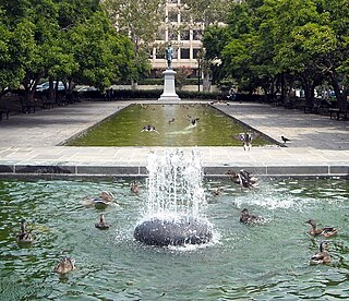
Judiciary Square is a neighborhood in the northwest quadrant of Washington, D.C., the vast majority of which is occupied by various federal and municipal courthouses and office buildings. Judiciary Square is located roughly between Pennsylvania Avenue to the south, H Street to the north, 6th Street to the west, and 3rd Street to the east. The center of the neighborhood is an actual plaza named Judiciary Square. The Square itself is bounded by 4th Street to the east, 5th Street to the west, D Street and Indiana Avenue to the south, and F Street to the north. The neighborhood is served by the Judiciary Square station on the Red Line of the Washington Metro, in addition to Washington Metropolitan Area Transit Authority bus stops.
Thomas Circle is a traffic circle in Northwest Washington, D.C., United States. It is located at the intersection of 14th Street, M Street, Massachusetts Avenue, and Vermont Avenue NW. A portion of Massachusetts Avenue travels through a tunnel underneath the circle. The interior of the circle includes the equestrian statue of George Henry Thomas, a Union Army general in the Civil War.
Sheridan Circle is a traffic circle and park in the Sheridan-Kalorama neighborhood of Washington, D.C. The traffic circle, one of two in the neighborhood, is the intersection of 23rd Street NW, Massachusetts Avenue NW, and R Street NW. The buildings along this stretch of Massachusetts Avenue NW are part of Embassy Row, which runs from Scott Circle to Observatory Circle. Sheridan Circle is a contributing property to the Massachusetts Avenue Historic District and the Sheridan-Kalorama Historic District, both listed on the National Register of Historic Places (NRHP). In addition, the equestrian statue of General Philip Sheridan is 1 of 18 Civil War Monuments in Washington, D.C., that were collectively listed on the NRHP.
Downtown is the central business district of Washington, D.C., located in Northwest D.C. It is the third largest central business district in the United States. The "Traditional Downtown" has been defined as an area roughly between Union Station in the east and 16th Street NW in the west, and between the National Mall on the south and Massachusetts Avenue on the north, including Penn Quarter. However, nowadays, Downtown D.C. usually refers to a larger area, as the DC Office of Planning states:
…most residents, workers, and visitors think of Downtown in a broader sense — including areas as far north as Dupont Circle, as far west as Foggy Bottom, and as far east as Capitol Hill. Only about half of the central city workforce is located within the city’s traditional Downtown.
The Sixteenth Street Historic District is a 1.25-mile (2.01 km) linear historic district in Washington, D.C., that includes all structures along 16th Street NW between H Street and Florida Avenue. The district's southern boundary is bordered by Lafayette Square, just north of the White House, and Meridian Hill Park on its northern boundary. It includes an eclectic mix of architectural styles on one of the city's most historic and important numbered streets including single and multi-family residential buildings, embassies, hotels, churches, and office buildings.
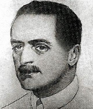
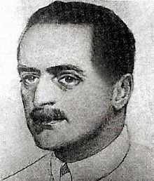
Jules Gabriel Henri de Sibour was a French architect who worked in Washington, DC.
The National Savings and Trust Company is a historic bank building located at the corner of New York Avenue and 15th Street, NW in Downtown Washington, D.C. It has also been known as the National Safe Deposit Company and the National Safe Deposit Savings and Trust Company.
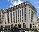
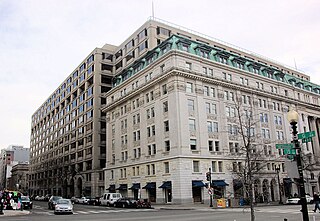
The American Security and Trust Company Building is a Neoclassical bank office in Washington, D.C., designed by the architectural firm of York and Sawyer. It was listed on the National Register of Historic Places in 1973.
Vlastimil Koubek was an American architect who designed more than 100 buildings, most of them in the Washington, D.C., metropolitan area, and whose total value topped $2 billion. Most of his work is Modernist in style, although he developed a few structures in other vernaculars. He created the site plan for the redevelopment of Rosslyn, Virginia, and his Ames Center anchored the area's economic recovery. He designed the World Building in Silver Spring, Maryland, which sparked redevelopment of that town's downtown; and the L'Enfant Plaza Hotel in Washington, D.C. In 1985, Washingtonian magazine called him one of 20 people "who in the past 20 years had the greatest impact on the way we live and who forever altered the look of Washington." In 1988, The Washington Post newspaper said his Willard Hotel renovation was one of 28 projects in the area that made a signal contribution to the "feel" and look of Washington, D.C.
The French ambassador's residence in Washington, D.C. is located at 2221 Kalorama Road, N.W., in the Kalorama neighborhood of northwest Washington, D.C.
The Mount Vernon Triangle Historic District is a historic district in the Mount Vernon Triangle neighborhood of Washington, D.C., consisting of 22 contributing residential, commercial, and industrial buildings, and one known archaeological site. The area was once a working class neighborhood for mostly German immigrants and home to semi-industrial enterprises such as a dairy and an automobile repair shop. The Northern Liberty Market that once stood on the corner of 5th Street and K Street NW played a large role in spurring development in the surrounding area as did the streetcars on Massachusetts Avenue and New York Avenue.
The Chase's Theater and Riggs Building, also known as the Keith-Albee Theater and the Keith-Albee Building, was a historic building located at 1426 G Street and 615-627 15th Street, Northwest, Washington, D.C., in the city's Downtown area.
The Kalorama Triangle Historic District is a mostly residential neighborhood and a historic district in the northwest quadrant of Washington, D.C. The entire Kalorama Triangle neighborhood was listed on the District of Columbia Inventory of Historic Sites (DCIHS) and National Register of Historic Places (NRHP) in 1987. In addition to individually listed landmarks in the neighborhood, the district is home to roughly 350 contributing properties. The neighborhood is roughly bounded by Connecticut Avenue to the west, Columbia Road to the east, and Calvert Street on the north.
Rawlins Park is a rectangular public park in the Foggy Bottom neighborhood of Washington, D.C., two blocks west of the White House grounds and two blocks north of the National Mall. The boundaries of the park are 18th Street NW to the east, E Street NW to the south and north, and 19th Street NW to the west. The park was an undeveloped open space for many years, until plans were made to install the statue of John Aaron Rawlins in 1874. Various improvements were made, but the area surrounding the park remained mostly undeveloped. This changed in the 1890s when the area was cleared of marshes, and houses were built on the park's southern border.
Appleton Prentiss Clark Jr. was an American architect from Washington, D.C. During his 60-year career, Clark was responsible for designing hundreds of buildings in the Washington area, including homes, hotels, churches, apartments and commercial properties. He is considered one of the city's most prominent and influential architects from the late 19th and early 20th centuries. Many of his designs are now listed on the National Register of Historic Places (NRHP).
The Sheridan-Kalorama Historic District is a neighborhood and historic district located in the northwest quadrant of Washington, D.C. The boundaries of the historic district include Rock Creek Park to the north and west, P Street to the south, and 22nd Street and Florida Avenue to the east. On the southwestern edge of the neighborhood is a stretch of Embassy Row on Massachusetts Avenue. The other neighborhood and historic district that lies to the east of Sheridan-Kalorama is Kalorama Triangle Historic District. The two neighborhoods are divided by Connecticut Avenue. For many years both neighborhoods were geographically connected before the stretch of Connecticut Avenue was installed towards the Taft Bridge. Often times, both neighborhoods are simply called "Kalorama" or "Kalorama Heights".
The Codman Carriage House and Stable is a historic building located at 1415 22nd Street NW in the Dupont Circle neighborhood of Washington, D.C. The industrial building was constructed in 1907 as a carriage house and stable for socialite and art collector Martha Catherine Codman, who lived a few blocks north in her home, later known as the Codman–Davis House. She commissioned her cousin, Ogden Codman Jr., an architect and prominent interior decorator who also designed her home. He designed it in a Second Empire style.
The Freedman's Bank Building, previously known as the Treasury Annex, is a historic office building located on the corner of Madison Place and Pennsylvania Avenue NW in Washington, D.C. It sits on the east side of Lafayette Square, a public park on the north side of the White House, and across from the Treasury Building. The adjoining properties include the Howard T. Markey National Courts Building to the north and the former Riggs National Bank to the east.
{{cite web}}
: CS1 maint: multiple names: authors list (link){{cite news}}
: CS1 maint: multiple names: authors list (link)