First Church of Christ, Scientist (Brighton)

Last updated

First Church of Christ, Scientist
First Church of Christ Scientist, 97 Montpelier Road, Brighton.jpg
The church from the west-northwest
Location map Brighton central.png
Red pog.svg
Location within Brighton
50°49′34″N0°09′07″W / 50.8261°N 0.1519°W / 50.8261; -0.1519
Location97 Montpelier Road, Montpelier, Brighton and Hove BN1 3BE
CountryUnited Kingdom
Denomination Christian Science
Website www.csbrighton.com
History
StatusChurch
Founded1921
Architecture
Functional statusActive
Architect(s) Clayton & Black
Style Regency/Neoclassical
Completed1921

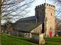
The First Church of Christ, Scientist is a church serving members of the Church of Christ, Scientist denomination in the English coastal city of Brighton and Hove. The present building, originally a "notable" private house in Brighton's exclusive Montpelier suburb, was extended and converted into a church by prolific local architecture firm Clayton & Black in 1921.

Contents

History

Montpelier was one of Brighton's earliest suburbs, laid out on a hillside between the 1820s and the 1860s [1] in response to the town's rapid development as a fashionable seaside resort. [2] The most rapid period of housebuilding was in the 1840s and 1850s, when Montpelier Road was developed with terraces of high-quality stuccoed Regency-style houses and larger villas. [3] Number 97 Montpelier Road was built in about 1850 at the south end, near the junction with the major commercial route of Western Road. [4] [5]

The church was converted from two houses (97 and 97a)which had in turn been converted from The Western College which itself was a conversion of Thomas Kemp's Montpelier House. First Church of Christ Scientist, Montpelier Road, Brighton (Entrance Bay).JPG
The church was converted from two houses (97 and 97a)which had in turn been converted from The Western College which itself was a conversion of Thomas Kemp's Montpelier House.

North Street was another important commercial street, lined with banks, offices, shops, inns and entertainment venues. [6] In 1890, the Athenaeum Recreation Hall was built at number 148. Equipped with several rooms and capable of holding 500 people, it became one of the first meeting places in Brighton of followers of Mary Baker Eddy's Church of Christ, Scientist movement. Worship took place there from the early 20th century, and another church—the Central Spiritualist Church—was later established there as well. [7] In 1921, Brighton architects Clayton & Black were commissioned (Charles Clayton had executed the original conversion of Montpelier House into two houses so was a natural choice to convert it back again) to convert 97 and 97a Montpelier Road (which had been acquired in 1909 and used as a separate church and reading room) back into a single large church to provide for the rapidly growing congregation. They substantially extended the building, creating a chapel to the south and embellishing the entrance in a Neoclassical style. [4]

The church is registered as a place of worship in accordance with the Places of Worship Registration Act 1855; its number on the register is 44386. [8] It lies within the Montpelier & Clifton Hill Conservation Area, one of 34 conservation areas in the city of Brighton and Hove. [9] This was designated by Brighton Council in 1973 and extended to 75.4 acres (30.5 ha) in 1977. [10] In their character statement published in 2005, Brighton and Hove City Council describe it as a "notable" [5] building in an area "contain[ing] a high proportion of listed buildings and high quality unlisted properties ... which together form a cohesive and attractive street scene." [11]

Architecture

The Clayton & Black firm started in the 1870s, and by 1921 they had designed a wide range of buildings for many functions and in a great variety of styles, including Flemish Renaissance, François Premier Revival and Edwardian Baroque. [12] Their two previous church commissions, both in Hove, [13] included the Gothic Revival St Thomas the Apostle's Church. [14] For their Montpelier Road commission, they added an elaborate Neoclassical-style façade to a house which, like its neighbours, reflected the transition from the Regency style to the Italianate; [15] some original features were kept though. [16] The whole façade is stuccoed [16] and there is rustication all round the entrance, which is set in a three-bay section to the left (north). This is elaborately treated, with arched and straight-headed windows, a frieze and a "richly decorated pediment". To the right, the body of the chapel has five bays separated by full-height pilasters. The ground-floor windows are flat-headed; those above are arched. There is a gallery inside, and timber panelling is used around the reader's dais. [4]

See also

Related Research Articles

<span class="mw-page-title-main">Royal Alexandra Children's Hospital</span> Hospital in England

The Royal Alexandra Children's Hospital is a children's hospital located within the grounds of the Royal Sussex County Hospital in Brighton on the south coast of England. It provides outpatient services, inpatient facilities, intensive care and a 24-hour emergency care service for children referred by GPs and other specialists. It is managed by University Hospitals Sussex NHS Foundation Trust.

<span class="mw-page-title-main">St Michael's Church, Brighton</span> Church

St. Michael's Church is an Anglican church in Brighton, England, dating from the mid-Victorian era. Located on Victoria Road in the Montpelier area, to the east of Montpelier Road, it is one of the largest churches in the city of Brighton and Hove. The church is a Grade I listed building.

<span class="mw-page-title-main">Grade II* listed buildings in Brighton and Hove</span>

There are 72 Grade II* listed buildings in the city of Brighton and Hove, England. The city, on the English Channel coast approximately 52 miles (84 km) south of London, was formed as a unitary authority in 1997 by the merger of the neighbouring towns of Brighton and Hove. Queen Elizabeth II granted city status in 2000.

<span class="mw-page-title-main">Grade II listed buildings in Brighton and Hove: C–D</span>

As of February 2001, there were 1,124 listed buildings with Grade II status in the English city of Brighton and Hove. The total at 2009 was similar. The city, on the English Channel coast approximately 52 miles (84 km) south of London, was formed as a unitary authority in 1997 by the merger of the neighbouring towns of Brighton and Hove. Queen Elizabeth II granted city status in 2000.

<span class="mw-page-title-main">Buildings and architecture of Brighton and Hove</span>

Brighton and Hove, a city on the English Channel coast in southeast England, has a large and diverse stock of buildings "unrivalled architecturally" among the country's seaside resorts. The urban area, designated a city in 2000, is made up of the formerly separate towns of Brighton and Hove, nearby villages such as Portslade, Patcham and Rottingdean, and 20th-century estates such as Moulsecoomb and Mile Oak. The conurbation was first united in 1997 as a unitary authority and has a population of about 253,000. About half of the 20,430-acre (8,270 ha) geographical area is classed as built up.

Thomas Lainson, FRIBA was a British architect. He is best known for his work in the East Sussex coastal towns of Brighton and Hove, where several of his eclectic range of residential, commercial and religious buildings have been awarded listed status by English Heritage. Working alone or in partnership with two sons as Lainson & Sons, he designed buildings in a wide range of styles, from Neo-Byzantine to High Victorian Gothic; his work is described as having a "solid style, typical of the time".

<span class="mw-page-title-main">Pelham Institute</span> Building in Brighton, England

The Pelham Institute is a former working men's club and multipurpose social venue in the Kemptown area of Brighton, part of the English coastal city of Brighton and Hove. Built in 1877 by prolific local architect Thomas Lainson on behalf of the Vicar of Brighton, the multicoloured brick and tile High Victorian Gothic building catered for the social, educational and spiritual needs of the large working-class population in the east of Brighton. After its closure it hosted a judo club, but is now in residential use as flats owned by a housing association. English Heritage has listed the building at Grade II for its architectural and historical importance.

<span class="mw-page-title-main">Carlton Hill, Brighton</span> Area of Brighton in East Sussex, England

Carlton Hill is an inner-city area of Brighton, part of the English city and seaside resort of Brighton and Hove. First developed in the early and mid-19th century on steeply sloping farmland east of central Brighton, it grew rapidly as the town became a fashionable, high-class destination. Carlton Hill's population was always poor, though, and by the early 20th century the area was Brighton's worst slum: overcrowding, crime and disease were rife. Extensive slum clearance in the mid-20th century introduced high-density tower blocks, but some old buildings remain: in 2008, Brighton and Hove City Council designated part of Carlton Hill as the city's 34th conservation area. The area now has housing of various styles and ages, large offices and small-scale industry; there are also churches, a school and some open space.

<span class="mw-page-title-main">Round Hill, Brighton</span> Inner suburban area in Brighton, UK

Round Hill is an inner suburban area of Brighton, part of the coastal city of Brighton and Hove in England. The area contains a mix of privately owned and privately rented terraced housing, much of which has been converted for multiple occupancies, and small-scale commercial development. It was developed mostly in the late 19th century on an area of high land overlooking central Brighton and with good views in all directions, the area became a desirable middle-class suburb—particularly the large terraced houses of Roundhill Crescent and Richmond Road, and the exclusive Park Crescent—and within a few decades the whole of the hill had been built up with smaller terraces and some large villas.

<span class="mw-page-title-main">Roundhill Crescent</span> 19th-century housing development in Brighton and Hove

Roundhill Crescent is a late-19th-century housing development in Round Hill, an inner suburb of the English coastal city of Brighton and Hove. Partly developed in the 1860s with large terraced houses on a steeply sloping open hillside, the crescent—which "curves and changes height dramatically along its length"—was finished two decades later and now forms the centrepiece of the Round Hill conservation area. Smaller houses completed the composition in the 1880s, and England's first hospital for the treatment of mental illness was founded in the crescent in 1905. The five original sets of houses from the 1860s have been listed at Grade II by English Heritage for their architectural and historical importance, and the crescent occupies a prominent place on Brighton's skyline.

<span class="mw-page-title-main">John Leopold Denman</span> British architect

John Leopold DenmanFRIBA was an architect from the English seaside resort of Brighton, now part of the city of Brighton and Hove. He had a prolific career in the area during the 20th century, both on his own and as part of the Denman & Son firm in partnership with his son John Bluet Denman. Described as "the master of ... mid-century Neo-Georgian", Denman was responsible for a range of commercial, civic and religious buildings in Brighton, and pubs and hotels there and elsewhere on the south coast of England on behalf of Brighton's Kemp Town Brewery. He used other architectural styles as well, and was responsible for at least one mansion, several smaller houses, various buildings in cemeteries and crematoria, and alterations to many churches. His work on church restorations has been praised, and he has been called "the leading church architect of his time in Sussex"; he also wrote a book on the ecclesiastical architecture of the county.

<span class="mw-page-title-main">Montpelier, Brighton</span> Inner suburban area of Brighton, England

Montpelier is an inner suburban area of Brighton, part of the English city and seaside resort of Brighton and Hove. Developed together with the adjacent Clifton Hill area in the mid-19th century, it forms a high-class, architecturally cohesive residential district with "an exceptionally complete character". Stucco-clad terraced housing and villas predominate, but two of the city's most significant Victorian churches and a landmark hospital building are also in the area, which lies immediately northwest of Brighton city centre and spreads as far as the ancient parish boundary with Hove.

<span class="mw-page-title-main">Montpelier Crescent</span> Historic site in East Sussex, United Kingdom

Montpelier Crescent is a mid 19th-century crescent of 38 houses in the Montpelier suburb of the English coastal city of Brighton and Hove. Built in five parts as a set-piece residential development in the rapidly growing seaside resort, the main part of the crescent was designed between 1843 and 1847 by prominent local architect Amon Henry Wilds and is one of his most distinctive compositions. Extra houses were added at both ends of the crescent in the mid-1850s. Unlike most other squares, terraces and crescents in Brighton, it does not face the sea—and the view it originally had towards the South Downs was blocked within a few years by a tall terrace of houses opposite. Montpelier was an exclusive and "salubrious" area of Brighton, and Montpelier Crescent has been called its "great showpiece". Wilds's central section has been protected as Grade II* listed, with the later additions listed separately at the lower Grade II. The crescent is in one of the city's 34 conservation areas, and forms one of several "outstanding examples of late Regency architecture" within it.

<span class="mw-page-title-main">Vernon Terrace, Brighton</span> Historic site in East Sussex, United Kingdom

Vernon Terrace is a mid 19th-century residential development in the Montpelier suburb of Brighton, part of the English coastal city of Brighton and Hove. Construction of the first section started in 1856, and the 37-house terrace was complete in the early 1860s. Architecturally, the houses divide into five separate compositions, although all are in a similar late Regency/Italianate style. This was characteristic of houses of that era in Brighton, and especially in the Montpelier area—where the Regency style persisted much later than elsewhere. Standing opposite is the landmark Montpelier Crescent, which had a view of the South Downs until Vernon Terrace blocked it. Three groups of houses in the terrace have been listed at Grade II by English Heritage for their architectural and historical importance.

Clayton & Black were a firm of architects and surveyors from Brighton, part of the English city of Brighton and Hove. In a career spanning the Victorian, Edwardian and interwar eras, they were responsible for designing and constructing an eclectic range of buildings in the growing town of Brighton and its neighbour Hove. Their work encompassed new residential, commercial, industrial and civic buildings, shopping arcades, churches, schools, cinemas and pubs, and alterations to hotels and other buildings. Later reconstituted as Clayton, Black & Daviel, the company designed some churches in the postwar period.

<span class="mw-page-title-main">Gwydyr Mansions</span> Mansion flats in Brighton and Hove, United Kingdom

Gwydyr Mansions is a block of mansion flats in the centre of Hove, part of the English coastal city of Brighton and Hove. Built on the initiative of a Baptist pastor and designed by the prolific architecture firm of Clayton & Black, the "elegant" Flemish Renaissance-style building dates from 1890 and overlooks a central square. As originally built, the block had a restaurant and barber shop for residents; the latter is still operational.

<span class="mw-page-title-main">163 North Street, Brighton</span> Building in Brighton, England

The building at 163 North Street in Brighton, part of the English coastal city of Brighton and Hove, was erected in 1904 for an insurance company and has since been used as a branch by several banks and building societies. It now houses a bookmaker's shop. The distinctive pink granite Edwardian Baroque-style office, embellished with towers, decorative carvings and a landmark cupola, has been called "the most impressive building" on Brighton's main commercial thoroughfare. One of many works by prolific local architecture firm Clayton & Black, it has been described as their chef d'œuvre. English Heritage has listed it at Grade II for its architectural and historical importance.

<span class="mw-page-title-main">Montpelier Place Baptist Church, Brighton</span> Church in Brighton , United Kingdom

Montpelier Place Baptist Church, originally known as the Baptist Tabernacle, is a former Baptist church in the Montpelier area of Brighton, part of the English seaside city of Brighton and Hove. It opened in 1967 to replace a 140-year predecessor on West Street in central Brighton, but was closed in 2012 and demolished over the 2017–2018 Christmas and New Year period. Houses and flats now occupy the site; the development was completed in December 2019.

References

Notes

  1. Antram & Morrice 2008 , p. 168.
  2. Antram & Morrice 2008 , p. 15.
  3. Antram & Morrice 2008 , p. 171.
  4. 1 2 3 Antram & Morrice 2008 , p. 172.
  5. 1 2 "Montpelier & Clifton Hill Conservation Area Character Statement" (PDF). Brighton & Hove City Council (Design & Conservation Department). 20 October 2005. p. 6. Archived (PDF) from the original on 28 September 2011. Retrieved 8 February 2013.
  6. Collis 2010 , p. 219.
  7. Collis 2010 , p. 221.
  8. Registered in accordance with the Places of Worship Registration Act 1855 (Number in Worship Register: 44386; Name: First Church of Christ, Scientist, Brighton; Address: 97 Montpelier Road, Brighton; Denomination: Christian Scientists. ( Archived version of list from April 2010 ; subsequent updates )
  9. "Conservation Areas in Brighton & Hove". Brighton & Hove City Council (Design & Conservation Department). 2010. Archived from the original on 27 September 2011. Retrieved 1 January 2012.
  10. "Montpelier & Clifton Hill Conservation Area Character Statement" (PDF). Brighton & Hove City Council (Design & Conservation Department). 20 October 2005. p. 1. Archived (PDF) from the original on 28 September 2011. Retrieved 8 February 2013.
  11. "Montpelier & Clifton Hill Conservation Area Character Statement" (PDF). Brighton & Hove City Council (Design & Conservation Department). 20 October 2005. p. 5. Archived (PDF) from the original on 28 September 2011. Retrieved 8 February 2013.
  12. Antram & Morrice 2008 , p. 23.
  13. Middleton 2002 , Vol. 3, p. 70.
  14. Elleray 2004 , p. 34.
  15. Antram & Morrice 2008 , p. 17.
  16. 1 2 Elleray 2004 , p. 12.

Bibliography

  • Antram, Nicholas; Morrice, Richard (2008). Brighton and Hove. Pevsner Architectural Guides. London: Yale University Press. ISBN   978-0-300-12661-7.
  • Collis, Rose (2010). The New Encyclopaedia of Brighton. (based on the original by Tim Carder) (1st ed.). Brighton: Brighton & Hove Libraries. ISBN   978-0-9564664-0-2.
  • Elleray, D. Robert (2004). Sussex Places of Worship. Worthing: Optimus Books. ISBN   0-9533132-7-1.
  • Middleton, Judy (2002). The Encyclopaedia of Hove & Portslade. Brighton: Brighton & Hove Libraries.