Gandhinagar, Tiruvannamalai

Last updated

Gandhinagar

Gandhinagar-Lakshmipuram
town
View over Arunchaleshvara Temple from the Red Mountain - Tiruvannamalai - India 01.JPG
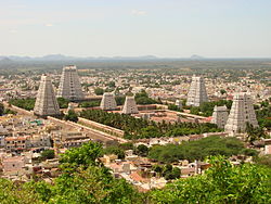
Annamalaiyar temple at Thiruvannamalai
India Tamil Nadu location map.svg
Red pog.svg
Gandhinagar
Location in Tamil Nadu, India
Coordinates: 12°13′N79°07′E / 12.22°N 79.11°E / 12.22; 79.11 Coordinates: 12°13′N79°07′E / 12.22°N 79.11°E / 12.22; 79.11
CountryFlag of India.svg  India
State Tamil Nadu
District Tiruvannamalai
Elevation
169 m (554 ft)
Population
 (2012)
  Total48,923
Languages
  Official Tamil
Time zone UTC+5:30 (IST)
PIN
606 602{fully} ,606 610 & 606 603 {partly}.
Telephone code91(04175)-
Vehicle registration TN-25
Rainfall76
Avg. summer temperature41 °C (106 °F)
Avg. winter temperature18 °C (64 °F)
Website www.injimedu.in

Gandhinagar-lakshmipuram is 3rd grade municipality in thiruvannamalai UA, constructed in the year 2002 from the former gandhinagar special grade town panchayat and laskmipuram area carved out from the thyagi annamalai nagar town panchayat of thiruvannamalai UA. Many new peoples considers Gandhinagar is the part of thiruvannamalai city but it only serves as a part of Thiruvannamalai UA.It spreads out on the Tindivanam and Pondicherry(via:villupuram & vettavalam)roads of thiruvannamalai UA.

Contents

Demographics

In 2001 gandhinagar has population of 30 thousand and in 2002 after joining of lakshmipuram {population :11000] it was totally 41000. Gandhinagar have a population of over 36 thousand and lakhmipurm have more than 15000 people totally this town having population of over 51000 providing sub urban to Tiruvannamalai urbanity. it comes under Tiruvannamalai urban agglomerations on Pondicherry Road NH 66 and Villupuram Road NH 234. There are two railway stations for Gandhinagar: one is "Gandinagar-Lakshmipuram" and another is Old Gandinagar at Villupuram - Pondicherry railway route.

Linguistic census
Linguistic groupsPercent(%)
Tamil
70.57%
Kannada
5.07%
Urdu
4.79%
Telugu
15.01%
Tulu
2.01%
Creole
0.4%
Malay
0.13%
Other
2.01%
Historical population
YearPop.±%
1901~100    
19812,450    
199121,057+759.5%
200141,430+96.8%
201163,327+52.9%
Sources:
  • 1951 – 2001 [1]

Related Research Articles

Chengam Selection Grade Town panchayat in Tamil Nadu, India

Chengam is a town in the Tiruvannamalai district of Tamil Nadu, India.

Melpattampakkam Town Panchayat in Tamil Nadu, India

Melpattampakkam is a panchayat town in Cuddalore district in the Indian state of Tamil Nadu.

Polur Town Panjayat in Tamil Nadu, India

Polur is a special grade Town Panjayat in Tiruvannamalai district at the state of Tamil Nadu in India. Located at the foothills of Javvadhi hills, a popular section of Eastern Ghats, Polur is often regarded as Gateway of Eastern ghats. The famous Chittor - Cuddalore road passes through the town. The town is located at 29 Kilometres north of city of Tiruvannamalai and 45 kilometres south of Vellore Metropolis.

Pudupalayam panchayat town in Tamil Nadu, India

Pudupalayam is a panchayat town in Chengam taluk of Tiruvanamalai district in the Indian state of Tamil Nadu. Its pincode number is 606 705.It is well connected with Tiruvannamalai and Bangalore. Pudupalayam Town Panchayat Located 34.00 K.M distance from Tiruvannamalai District. Nearest Railway Station Name :Tiruvannamalai, This Railway Station Located 34.00 k.m Distance from pudupalayam Nearest Airport Located is Chennai. Bus Route Details :Polur To Chengam and Tiruvannamalai to Pudupalayam. Kavitha Seva Trust is running in Pudupalayam village to offer welfare facilities for elder peoples and terminally illness peoples by providing food, shelter and basic medical facilities.

Thiyagadurgam is a panchayat town in kallakurichi district in the Indian state of Tamil Nadu.

Tindivanam town in Tamil Nadu, India

Tindivanam is a town and a municipality in Viluppuram district in the Indian state of Tamil Nadu. It is the second largest town in Villupuram District after the headquarters town Villupuram. Important roads from north to south Tamil Nadu pass through Tindivanam and similarly from west to east.

Valavanur town in Tamil Nadu, India

Valavanur is a panchayat town in Viluppuram district in the Indian state of Tamil Nadu. It is situated near to the Tamil Nadu–Puducherry border on NH 45A.

Vettavalam Town Panchayat in Tamil Nadu, India

Vettavalam is a first grade panchayat town in Tiruvanamalai district in the Indian state of Tamil Nadu.

Arani, Tiruvannamalai Select Grade Municipality in Tamilnadu, India

'Arni otherwise spelled Arani, also Periya Arani is a town and a municipality in Tiruvanamalai district in the state of Tamil Nadu, India. The name comes from the word Aranyam which means a place surrounded by forest. Arani is known for its rich history - a Fort and few palaces, ancient Hindu temples and Jain centres stand today as a testimony. For more than thirty years, Arani, Polur, Cheyyar, Vandavasi people have been demanding the creation of a new district headed by Arani.

Viluppuram Place in Tamil Nadu, India

Viluppuram, Villupuram, or Vizhuppuram is a Municipality and the administrative headquarters of Vizhuppuram district.

National Highway 66 (India, old numbering)

National Highway 66 is a National Highway in India. This is the main National Highway to connect Pondicherry with Krishnagiri. It starts from Indira Gandhi Square in Pondicherry and runs north west till Tindivanam in Villupuram district then runs westward till Uthangarai via Thiruvannamalai and then joins NH 46 at Krishnagiri. NH 46 starts from NH 7 which is at 1 km (0.62 mi) from the junction of NH 66. The total length runs to 214 km (133 mi).

Devikapuram Place in Tamil Nadu, India

Devikapuram, also called Devigai, is a town and a Panchayat board in Tiruvannamalai district, located in Tamil Nadu, India. The town is famous for handlooms, Silk weaving and ricemills, which process Arni Ponni rice. Located on the Polur - Sadras state highway, 45 kilometres from the city of Tiruvannamalai, also the district headquarters.

Thyagi Annamalai Nagar Town panchayat in Tamil Nadu, India

Thyagi annamalai nagar or Thyagi annamalaipuram or T.A.Nagar is a 1st-grade town panchayat constructed as a 3rd-grade town panchayat in 1994 and upgraded to 2nd grade in 2002 and 1st grade in 2007. Thyagi Annamalai nagar has declined in population in census due to carving to its sub-area Laksmipuram because main T.nagar comprises population of 19,000 and Lakshmipuram has a population of 11,000 in 2001 census totally. 30,000 is the population of Thyagi Anamalai Nagar. But in 2011 T. Anagar had its own population of 23,000.

Thenimalai town in Tamil Nadu, India

Thenimali is a panchayat town in Indian state of Tamil Nadu. It is a suburb of Thiruvannamalai UA.

Kilnathur panchayat town in Tamil Nadu, India

Kilnathur, also known as kizh-arunai, is a suburb and town panchayat in Thiruvannaamalai district, Tamil Nadu, India. It is one of the oldest settlements in North arcot region. It developed along with Tiruvannamalai. It spreads on the Pondicherry Road {via:Villupuram}. It is the next area to gandhinagar.

The town of Viluppuram in the Indian state of Tamil Nadu is well connected by both rail and road to other major cities in the state including Chennai, Trichy, Madurai, Salem, Thanjavur, Coimbatore, Dindigul and Vellore. And also other state major cities such as Bengaluru, Tirupati, Pondicherry and Mangalore. Viluppuram serves as one of the important railway junction of Tamil Nadu and Southern Railway Zone. The nearest domestic airport is Pondicherry, which has a daily chartered flight to Bengaluru. The nearest international airports are Chennai and Tiruchirappalli.

National Highway 77 (India) National Highway in India

National Highway 77 is a National Highway in India. This is the main National Highway to connect Pondicherry with Krishnagiri. It starts from Tindivanam in Villupuram district then runs westward till Uthangarai via Thiruvannamalai and then joins NH 48 at Krishnagiri. NH-77 runs entirely in the state of Tamil Nadu.

Tirupattur Town in Tamil Nadu, India

The town of Tirupathur or Tirupattur is the headquarters of Tirupathur district in southern India and is one of the oldest inhabited places in the state of Tamil Nadu, with a history of over 1,600 years. The town is known for abundant sandalwood in the surrounding hills. It is located about 89 km (55 mi) southwest of Vellore, 85 km (53 mi) from Hosur and Thiruvannamalai to the northwest and southeast, 210 km (130 mi) west of Chennai, and 125 km (78 mi) east of Bangalore.

Arani Road Railway Junction

Arani Road Railway Junction is located in Kalambur, Arani in the Tiruvannamalai District.

Tiruvannamalai Town in Tamil Nadu, India

Tiruvannamalai is a town in the Indian state of Tamil Nadu. The city is administered by a special grade municipality that covers an area of 13.64 km2 (5.27 sq mi) and a population of 145,278. It is the administrative headquarters of Tiruvannamalai District. Roadways are the major mode of transport in Tiruvannamalai, while the town also has rail connectivity. Chennai International Airport is the nearest domestic and international airport to the town. Tiruvannamalai is named after the central deity of the Annamalaiyar Temple, Annamalaiyar. The Karthigai Deepam festival is celebrated during the day of the full moon between November and December, and a huge beacon is lit atop the Annamalai hill. The event is witnessed by three million pilgrims. On the day preceding each full moon, pilgrims circumnavigate the temple base and the Annamalai hills in a worship called Girivalam, a practice carried out by one million pilgrims yearly.

References

  1. "Population Details". Tiruvannamalai municipality. 2011. Archived from the original on 27 February 2014. Retrieved 29 December 2012.