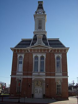
Greenfield, Ohio | |
---|---|
Motto: "A Perfect Place To Raise A Family" | |
Coordinates: 39°21′00″N83°22′45″W / 39.35000°N 83.37917°W | |
Country | United States |
State | Ohio |
Counties | Highland, Ross |
Area | |
• Total | 2.09 sq mi (5.40 km2) |
• Land | 2.09 sq mi (5.40 km2) |
• Water | 0.00 sq mi (0.00 km2) |
Elevation | 925 ft (282 m) |
Population (2020) | |
• Total | 4,339 |
4,336 | |
• Density | 2,080.06/sq mi (803.27/km2) |
Time zone | UTC-5 (Eastern (EST)) |
• Summer (DST) | UTC-4 (EDT) |
ZIP codes | 45123, 45165 |
Area code(s) | 937, 326 |
FIPS code | 39-32088 [4] |
GNIS feature ID | 2394985 [2] |
Website | greenfieldohio |
Greenfield is a village in Highland and Ross counties, Ohio, United States. As of the 2020 census, the population was 4,339.
Greenfield was named for its rural appearance, and was founded by General Duncan McArthur in 1799. [5]
Most of Greenfield's early settlers moved to Ohio to work in anti-slavery efforts. In April 1833, the Abolition Society of Paint Valley was founded. Its main effort was to educate and do missionary work in the stance of ending slavery. [6] The Abolition Society of Paint Valley was later disbanded but was quickly re-organized as the Greenfield Antislavery Society. Records become thin due to the large number of citizens helping African Americans to gain freedom. [6] Greenfield played a major part in the ending of slavery. Former slaves passed through the area on their way to Canada during the operation of the Underground Railroad with much help from Greenfield's community members. [7]
In 1893, the first African American owned car company was first founded in Greenfield. The C.R. Patterson and Sons company started as a horse-drawn buggy company but later produced cars, buses, and trucks. C.R. Patterson, alongside J.P. Lowe, moved to Greenfield where they founded the car company. The C.R. Patterson and Sons car company provided Greenfield schools buses to conduct routes. [8] Other industries in Greenfield include Ruckers Quarry, which day and night quarried stone such as limestone on a large scale for the Cincinnati market. [9] Another industry was Harps Manufacturing which was most well known for the Never-fail Oil Can, which was originally designed by Eugene Arnott but then perfected by Harp's Manufacturing. [9]
Edward Lee McClain High School opened on September 23, 1915. People who wished to attend paid a fee of 15 cents for admission. [9] It was the first school in Ohio to have an indoor swimming pool, which is still there today, with minor construction revisions. [7]
In 1988, the 29.5-mile railroad line connecting the city to the national rail network was scheduled to be decommissioned, but Greenfield bought it for $2.4 million and kept it operational in order to retain a transportation outlet for the local manufacturing industry. This also made the city the smallest in the U.S. to own its own rail line. [10]
Much of Greenfield's early history concentrates on the Travellers' Rest Inn at the eastern end of Jefferson Street. Constructed in 1812, it was the village's first stone building. It also served as its first post office, and was the space for its first doctor's office. [11] Now operated as a museum, [12] the inn is listed on the National Register of Historic Places. The Samuel Smith House and Tannery is also listed on the National Register. [13]
Greenfield is located almost entirely in Highland County. [14]
According to the United States Census Bureau, the city has a total area of 2.06 square miles (5.34 km2), all land. [15]
Greenfield receives an annual average of 38 inches of rain, and averages 25 inches of snow. Both averages are very similar to those of the United States. Greenfield averages 173 sunny days and 128 rainy days. The average high temperature in July is 84 degrees and the average low in January is 20.6 degrees. [16]
Census | Pop. | Note | %± |
---|---|---|---|
1850 | 1,011 | — | |
1860 | 1,500 | 48.4% | |
1870 | 1,712 | 14.1% | |
1880 | 2,104 | 22.9% | |
1890 | 2,460 | 16.9% | |
1900 | 3,979 | 61.7% | |
1910 | 4,228 | 6.3% | |
1920 | 4,344 | 2.7% | |
1930 | 3,871 | −10.9% | |
1940 | 4,228 | 9.2% | |
1950 | 4,862 | 15.0% | |
1960 | 5,422 | 11.5% | |
1970 | 4,780 | −11.8% | |
1980 | 5,150 | 7.7% | |
1990 | 5,172 | 0.4% | |
2000 | 4,906 | −5.1% | |
2010 | 4,639 | −5.4% | |
2020 | 4,339 | −6.5% | |
2023 (est.) | 4,336 | [3] | −0.1% |
U.S. Decennial Census [17] |
As of the census [18] of 2010, there were 4,639 people, 1,829 households, and 1,148 families residing in the city. The population density was 2,251.9 inhabitants per square mile (869.5/km2). There were 2,141 housing units at an average density of 1,039.3 per square mile (401.3/km2). The racial makeup of the city was 95.9% White, 1.7% African American, 0.1% Native American, 0.2% Asian, 0.3% from other races, and 1.7% from two or more races. Hispanic or Latino people of any race were 0.8% of the population.
There were 1,829 households, of which 33.7% had children under the age of 18 living with them, 38.4% were married couples living together, 17.8% had a female householder with no husband present, 6.5% had a male householder with no wife present, and 37.2% were non-families. 32.1% of all households were made up of individuals, and 15% had someone living alone who was 65 years of age or older. The average household size was 2.47 and the average family size was 3.07.
The median age in the city was 37.1 years. 25.9% of residents were under the age of 18; 8.7% were between the ages of 18 and 24; 25.3% were from 25 to 44; 24.4% were from 45 to 64; and 15.8% were 65 years of age or older. The gender makeup of the city was 47.5% male and 52.5% female.
As of the census [4] of 2000, there were 4,906 people, 1,955 households, and 1,253 families residing in the village. The population density was 2,536.3 inhabitants per square mile (979.3/km2). There were 2,099 housing units at an average density of 1,085.1 per square mile (419.0/km2). The racial makeup of the village was 95.78% White, 2.20% African American, 0.08% Native American, 1.28% Asian, 0.12% Pacific Islander, 0.33% from other races, and 1.41% from two or more races. Hispanic or Latino people of any race were 0.69% of the population.
There were 1,955 households, out of which 31.4% had children under the age of 18 living with them, 44.3% were married couples living together, 15.3% had a female householder with no husband present, and 35.9% were non-families. 30.9% of all households were made up of individuals, and 15.4% had someone living alone who was 65 years of age or older. The average household size was 2.44 and the average family size was 3.04.
In the village, the population was spread out, with 26.4% under the age of 18, 9.6% from 18 to 24, 26.2% from 25 to 44, 21.3% from 45 to 64, and 16.6% who were 65 years of age or older. The median age was 36 years. For every 100 females, there were 85.6 males. For every 100 females age 18 and over, there were 81.8 males.
The median income for a household in the village was $30,805, and the median income for a family was $36,952. Males had a median income of $32,156 versus $21,352 for females. The per capita income for the village was $14,306. About 12.3% of families and 15.1% of the population were below the poverty line, including 16.5% of those under age 18 and 13.6% of those age 65 or over.
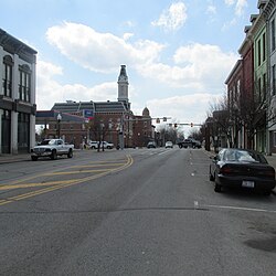
As of 2018, Greenfield's village council consists of Phil Clyburn, Amie Ernst, Brenda Losey, and Dr. Eric Borsini. [19]
Other officials include City Manager Todd Wilkin, Finance Director Gary Lewis, Police Chief Jeremiah Oyer, Law Director Hannah Bivens, and Clerk of Council Sherry Parker. [19]
Greenfield Exempted Village Schools operates three elementary schools (Rainsboro, Buckskin, and Greenfield Elementary), one middle school, and McClain High School. [20]
Greenfield has a public library, a branch of the Highland County District Library. [21]
Highland County is a county located in the U.S. state of Ohio. As of the 2020 census, the population was 43,317. Its county seat is Hillsboro. The county is named for the topography which is hilly and divides the watersheds of the Little Miami and Scioto Rivers. Highland County was created on May 1, 1805, from land taken from Ross, Adams, and Clermont counties.
Fayette County is a county located in the U.S. state of Ohio. As of the 2020 census, the population was 28,951. Its county seat and largest city is Washington Court House. The county was named for the Marquis de Lafayette, a Frenchman who was an officer in the American Army in the Revolution, when established on March 1, 1810. Fayette County comprises the Washington Court House, OH Micropolitan Statistical Area, which is also included in the Columbus-Marion-Zanesville, OH Combined Statistical Area.
Greenfield is a city in Dade County, Missouri. The population was 1,220 at the 2020 census. It is the county seat of Dade County.
Highland Heights is a city in Cuyahoga County, Ohio, United States. The city's population was 8,719 as of the 2020 census. An eastern suburb of Cleveland, it is part of the Cleveland metropolitan area.
Highland Hills is a village in Cuyahoga County, Ohio, United States. The population was 662 at the 2020 census. A suburb of Cleveland, it was formally incorporated in 1990.
Mayfield is a village in eastern Cuyahoga County, Ohio, United States. A suburb of Cleveland, it is part of the Cleveland metropolitan area. The population was 3,356 at the 2020 census.
Urbancrest is a village in Franklin County, Ohio, United States. The population was 1,031 at the 2020 census. Urbancrest is in the South-Western City Schools District.
Addyston is a village in Miami Township, Hamilton County, Ohio, United States. Located along the Ohio River, it is a western suburb of the neighboring city of Cincinnati. The population was 927 at the 2020 census.
Madeira is a city in Hamilton County, Ohio, United States. The population was 9,487 at the 2020 census. A residential suburb of Cincinnati, Madeira has a small downtown and some light industry.
Mariemont is a village in eastern Hamilton County, Ohio, United States. The population was 3,518 at the 2020 census. A planned community in the Cincinnati metropolitan area, it includes two overlapping historic districts, the Village of Mariemont and Mariemont Historic District. In 2007, the Village of Mariemont was designated a National Historic Landmark.
North Bend is a village in Miami Township, Hamilton County, Ohio, United States, along the Ohio River. It is a part of the Greater Cincinnati area. The population was 835 at the 2020 census.
The Village of Indian Hill is a city in Hamilton County, Ohio, United States, and a suburb of the Greater Cincinnati area. The population was 6,087 at the 2020 census. Prior to 1970, Indian Hill was incorporated as a village, but under Ohio law became designated as a city once its population was verified as exceeding 5,000. The municipality then changed its name to add "Village", and legally it is known as "The City of The Village of Indian Hill". The Village of Indian Hill is served by the Indian Hill Exempted Village School District.
Highland is a village in Fairfield Township, Highland County, Ohio, United States. The population was 232 at the 2020 census.
Leesburg is a village in Highland County, Ohio, United States. The population was 1,273 at the 2020 census.
Willard is a city in southwestern Huron County, Ohio, United States, approximately 14 miles (23 km) southwest of Norwalk. The population was 6,197 at the 2020 census.
Riverside is a city in Montgomery County, Ohio, United States. The population was 24,474 at the 2020 census. A suburb of Dayton, it is part of the Dayton metropolitan area.
Sardinia is a village in Brown and Highland counties in the U.S. state of Ohio. The population was 1,083 at the 2020 census.
Clifton is a village in Clark and Greene counties in the U.S. state of Ohio and is home to the Clifton Mill, one of the largest water-powered grist mills still in existence. The population was 131 at the 2020 census.
Lynchburg is a village in Clinton and Highland counties in the U.S. state of Ohio. The population was 1,510 at the 2020 census.
Highland is a village in Iowa County, Wisconsin, United States. The population was 874 at the 2020 census. It is part of the Madison Metropolitan Statistical Area. The village is located within the Town of Highland.