
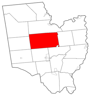
Highland County is a county located in the U.S. state of Ohio. As of the 2020 census, the population was 43,317. Its county seat is Hillsboro. The county is named for the topography which is hilly and divides the watersheds of the Little Miami and Scioto Rivers. Highland County was created on May 1, 1805, from land taken from Ross, Adams, and Clermont counties.

Greenfield is a city in and the county seat of Hancock County, Indiana, United States It lies in Center Township and is part of the Indianapolis metropolitan area. The population was 23,488 at the 2020 census.

Bernardston is a town in Franklin County, Massachusetts, United States. The population was 2,102 at the 2020 census. It is part of the Springfield, Massachusetts Metropolitan Statistical Area.

Buckland is a town in Franklin County, Massachusetts, United States. The population was 1,816 at the 2020 census. The town shares the village of Shelburne Falls with neighboring Shelburne. The town center at Shelburne Falls is the western end of the Bridge of Flowers, a local tourist attraction.

Charlemont is a town in Franklin County, Massachusetts, United States. The population was 1,185 at the 2020 census. It is part of the Springfield, Massachusetts Metropolitan Statistical Area.

Shelburne is a town in Franklin County, Massachusetts, United States. The population was 1,884 at the 2020 census. It is part of the Springfield, Massachusetts Metropolitan Statistical Area.
Bennington is a town in Hillsborough County, New Hampshire, United States. The population was 1,501 at the 2020 census.

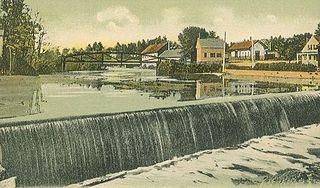
Greenfield is a town in Hillsborough County, New Hampshire, United States. The population was 1,716 at the 2020 census. Greenfield is home to the Crotched Mountain Rehabilitation Center, to Greenfield State Park, and to part of the Wapack Trail.
Greenfield is a town in Saratoga County, New York, United States. It is located northwest of Saratoga Springs, and is the largest by area in the county. Students living in Greenfield attend schools of the Saratoga Springs City School District. The Palmertown, and Kayaderosseras Ranges pass through the town, the town is located at the foothills of the Adirondack Mountains.

Greenfield Township is a township in Blair County, Pennsylvania, United States. It is part of the Altoona, PA Metropolitan Statistical Area. The population was 3,785 at the 2020 census.
Daleville is a census-designated place (CDP) in southern Botetourt County, Virginia, United States. The population was 3,070 at the 2020 census. The CDP is located along U.S. Route 220. It is part of the Roanoke Metropolitan Statistical Area.

Greenfield is a city in Milwaukee County, Wisconsin, United States. The population was 37,803 as of the 2020 census. Greenfield is one of many bedroom communities in the Milwaukee metropolitan area.

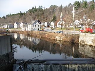
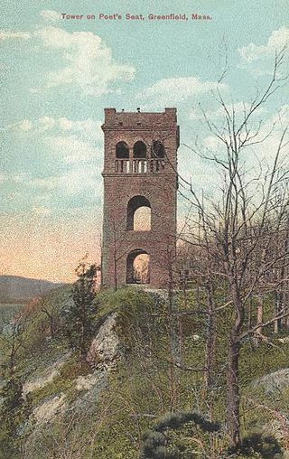
Greenfield is the county seat, and sole city, of Franklin County, Massachusetts, United States. Greenfield was first settled in 1686. The population was 17,768 at the 2020 census. Greenfield is home to Greenfield Community College, the Pioneer Valley Symphony Orchestra, the Franklin County Fair, and the Green River Festival. The city has a Main Street Historic District containing fine examples of Federal, Greek Revival, and Victorian architecture.
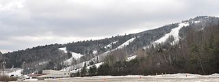
Crotched Mountain is a small mountain in western Hillsborough County, New Hampshire, in the United States. The 2,063-foot (629 m) summit of the mountain is in the town of Francestown, while the western slopes of the mountain rise in the town of Bennington, and a long southern ridge of the mountain is in Greenfield. The mountain was named for its appearance. Early settlers thought its V-shaped peaks resembled the fork or "crotch" of a tree.
Stony Brook is a 10.6-mile-long (17.1 km) river located in southern New Hampshire in the United States. It is a tributary of the Souhegan River, which flows to the Merrimack River and ultimately to the Gulf of Maine.

Pocumtuck Mountain is a mountain peak in Charlemont, Massachusetts, located west of the abandoned Catamount settlement. Its summit ledge features wide views of western Franklin County and northern Berkshire County. Pocumtuck Mountain is often confused with the nearby Pocumtuck Range in Deerfield, Massachusetts.

The Wapack Range, sometimes referred to as the Pack Monadnock Range, is a 20-mile-long (32 km) range of mountains in south-central New Hampshire and adjacent Massachusetts, in the northeastern United States. The range is considered very scenic and rugged with many bare summits and ledges ranging from 1,800 to 2,290 feet. The 22-mile (35 km) Wapack Trail, one of the oldest interstate hiking trails in the United States, traverses it. The Wapack Range is also the northern terminus of the 90-mile (140 km) Midstate Trail.
The Pocumtuck Range, also referred to as the Pocumtuck Ridge, is the northernmost subrange of the Metacomet Ridge mountain range of southern New England, itself a subrange of the Appalachian Mountains. Located in Franklin County, Massachusetts, between the Connecticut River and the Deerfield River valleys, the Pocumtuck Range is a popular hiking destination known for its continuous high cliffs, scenic vistas, and microclimate ecosystems.

Western Gateway Heritage State Park is a history-focused Massachusetts state park in the city of North Adams managed by the Department of Conservation and Recreation. Exhibits at the park, which is located in a former railyard, tell the story of the creation of the Hoosac Tunnel. The freight yard was listed on the National Register of Historic Places in 1972 as the Freight Yard Historic District.
The Pennsylvania State Game Lands Number 41 are Pennsylvania State Game Lands in Bedford and Blair Counties in Pennsylvania in the United States providing hunting, bird watching, and other activities.

