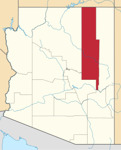
Hard Rock, Arizona | |
---|---|
Coordinates: 36°01′51″N110°30′17″W / 36.03083°N 110.50472°W | |
Country | United States |
State | Arizona |
County | Navajo |
Area | |
• Total | 5.92 sq mi (15.34 km2) |
• Land | 5.92 sq mi (15.34 km2) |
• Water | 0.00 sq mi (0.00 km2) |
Elevation | 6,021 ft (1,835 m) |
Population (2020) | |
• Total | 38 |
• Density | 6.42/sq mi (2.48/km2) |
Time zone | UTC-7 (MST) |
Area code | 928 |
FIPS code | 04-31182 |
GNIS feature ID | 2582797 [2] |
Hard Rock is a census-designated place (CDP) in Navajo County, Arizona, United States. The population was 94 at the 2010 census.
The CDP has a total area of 5.92 square miles (15.3 km2), all land. [3]
Census | Pop. | Note | %± |
---|---|---|---|
2020 | 38 | — | |
U.S. Decennial Census [4] |
As of the 2010 census, there were 94 people living in the CDP: 43 male and 51 female. 37 were 19 years old or younger, 20 were ages 20–34, 17 were between the ages of 35 and 49, 9 were between 50 and 64, and the remaining 11 were aged 65 and above. The median age was 30.0 years.
The racial makeup of the CDP was 94.7% American Indian, 3.2% Asian, 1.1% White, and 5.3% two or more races. 12.8% of the population were Hispanic or Latino of any race.
There were 28 households in the CDP, 20 family households (71.4%) and 8 non-family households (28.6%), with an average household size of 3.36. Of the family households, 10 were married couples living together, 8 were single mothers, and 2 w3ere single fathers; the non-family households included 8 adults living alone: 3 male and 5 female.
The CDP contained 41 housing units, of which 28 were occupied and 13 were vacant. [5]
Rock Point is a census-designated place (CDP) in Apache County, Arizona, United States. The population was 642 at the 2010 census. Its name is descriptive of the point where Chinle Creek enters high sandstone walls.
Round Rock is a Navajo community and census-designated place (CDP) in Apache County, Arizona, United States. The population was 789 at the 2010 census. It is named after a nearby mesa.
LeChee is a census-designated place (CDP) in Coconino County, Arizona, United States. The population was 1,443 at the 2010 census.
Centennial Park is an unincorporated community and census-designated place (CDP) in Mohave County, Arizona, United States. The population was 1,578 at the 2020 census, up from 1,264 at the 2010 census. It is the central location for the Centennial Park group, a fundamentalist Mormon group.
Oljato-Monument Valley is a census-designated place (CDP) in Navajo County, Arizona, United States. The population was 154 at the 2010 census.
Chiawuli Tak is both a census-designated place (CDP) as well as a populated place in Pima County, Arizona, United States. Chiawuli Tak means "the barrel cactus sits" in the O'odham language. It is also unofficially known as Geowic, Jeowic, or Tjeavolitak. The population was 78 at the 2010 census.
Crozier is an unincorporated community and census-designated place (CDP) in Mohave County, Arizona, United States. The population was 21 at the 2020 census.
Clacks Canyon is a census-designated place (CDP) in Mohave County, Arizona, United States. The population was 167 at the 2020 census.
Crystal Beach is an unincorporated community in Mohave County, Arizona, United States. The population was 250 at the 2020 census. For statistical purposes, the United States Census Bureau has defined Crystal Beach as a census-designated place (CDP).
Golden Shores is a census-designated place (CDP) in Mohave County, Arizona, United States. The population was 1,927 at the 2020 census. Residents are part of the 86436 ZIP code area, with a mailing address of Topock.
Haivana Nakya is a census-designated place (CDP) in Pima County, Arizona, United States. The population was 96 at the 2010 census.
Hondah is a census-designated place (CDP) in Navajo County, Arizona, United States, on the Fort Apache Indian Reservation. The population was 812 at the 2010 census.
Katherine is an unincorporated community and census-designated place (CDP) in Mohave County, Arizona, United States. The population was 76 at the 2020 census, down from 103 at the 2010 census.
Elephant Head is a census-designated place (CDP) in Pima County, Arizona, United States. The population was 612 at the 2010 census.
Lazy Y U is an unincorporated community and census-designated place (CDP) in Mohave County, Arizona, United States. The population was 474 at the 2020 census, up from 428 at the 2010 census.
McConnico is an unincorporated community and census-designated place (CDP) in Mohave County, Arizona, United States. The population was 63 at the 2020 census.
North Fork is a census-designated place (CDP) in Navajo County, Arizona, United States, on the Fort Apache Indian Reservation. The population was 1,417 at the 2010 census.
Pimaco Two is a census-designated place (CDP) located in Pima County, Arizona, United States. The population was 682 at the 2010 census.
Pine Lake is an unincorporated community and census-designated place (CDP) in Mohave County, Arizona, United States. The population was 142 at the 2020 census.
Pinion Pines is an unincorporated community and census-designated place (CDP) in Mohave County, Arizona, United States. The population was 158 at the 2020 census.