
Navajo County is a county in the northern part of the U.S. state of Arizona. As of the 2020 census, its population was 106,717. The county seat is Holbrook.
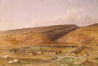
Fort Defiance is a census-designated place (CDP) in Apache County, Arizona, United States. It is also located within the Navajo Nation. The population was 3,624 at the 2010 census.
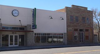
St. Johns is the county seat of Apache County, Arizona, United States. It is located along U.S. Route 180, mostly west of where that highway intersects with U.S. Route 191. As of the 2010 census, the population of the city was 3,480.

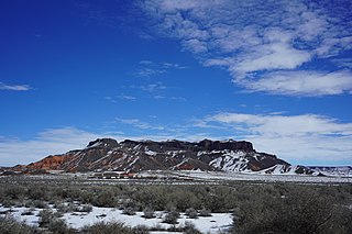
Window Rock, known in Navajo as Tségháhoodzání, is a city and census-designated place that serves as the capital of the Navajo Nation, the largest Native American tribe by both land and tribal enrollment. The capital lies within the boundaries of the St. Michaels Chapter, adjacent to the Arizona and New Mexico state line. Window Rock is the site of the Navajo Nation governmental campus, which contains the Navajo Nation Council, Navajo Nation Supreme Court, the offices of the Navajo Nation President and Vice President, and many Navajo government buildings.
Holbrook is a city in Navajo County, Arizona, United States. According to the 2010 census, the population of the city was 5,053. The city is the county seat of Navajo County.

Sun Valley is a populated place in Navajo County, Arizona, United States, east of Holbrook along Interstate 40. It is located in the Painted Desert and covers an area of 31.6 square miles.

Tolani Lake is a census-designated place in the eastern portion of Coconino County, Arizona, United States, near the Navajo County border. Tolani Lake is located north of Winslow. The population as of the 2010 U.S. Census was 280.
Aripine is a populated place situated in Navajo County, Arizona, United States.

Baby Rocks is a populated place situated in Navajo County, Arizona, United States, and appears on the Baby Rocks U.S. Geological Survey Map.
Bidahochi is a populated place situated in Navajo County, Arizona, United States. The nearby Bidahochi Formation was named for Bidahochi.
Burton is a populated place situated in Navajo County, Arizona, United States.
Castle Butte is a populated place situated in Navajo County, Arizona, United States. It has an estimated elevation of 5,807 feet (1,770 m) above sea level.
Chakpahu is a populated place situated in Navajo County, Arizona, United States. It has an estimated elevation of 6,375 feet (1,943 m) above sea level.
Hidden Springs is a populated place situated in Coconino County, Arizona, United States, located on U.S. 89 approximately 75 miles north of Flagstaff. It has an estimated elevation of 4,819 feet (1,469 m) above sea level. The San Juan Southern Paiute Tribe of Arizona is located there.
Manila is a populated place situated in Navajo County, Arizona, United States. Its name was bestowed during the Spanish–American War, being named after the Philippines' capital, and has an estimated elevation of 4,954 feet (1,510 m) above sea level.
Navajo is a populated place situated in Apache County, Arizona, United States. It has an estimated elevation of 5,676 feet (1,730 m) above sea level.
Pine Springs is a populated place situated in Apache County, Arizona, United States.
Twin Buttes is a populated place situated in Navajo County, Arizona, United States. It is one of two populated locations in Arizona with this name, the other being in Pima County. It has an estimated elevation of 5,794 feet (1,766 m) above sea level.
Wepo Village is a populated place situated in Navajo County, Arizona, United States. It has an estimated elevation of 5,784 feet (1,763 m) above sea level. Located 5 miles north of Walpi, it is within the boundaries of the Hopi Reservation The name comes from the Hopi word for "onion".
Wheatfields is a populated place situated in Apache County, Arizona, United States, right along the border with New Mexico. It has an estimated elevation of 7,287 feet (2,221 m) above sea level. It is one of two places in Arizona with this name, the other being a CDP in Gila County. In 1909, the US Government set up an irrigation project to assist the Navajo residents. It is a chapter of the Navajo Nation.


