Rainbow City, Arizona

Last updated

Rainbow City, Arizona
CDP
Navajo County Arizona Incorporated and Unincorporated areas Rainbow City Highlighted 0458620.svg
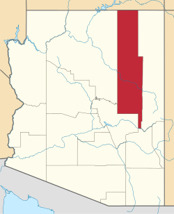
Location of Rainbow City in Navajo County, Arizona.
USA Arizona location map.svg
Red pog.svg
Rainbow City, Arizona
Location in the United States
Coordinates: 33°52′33″N109°58′36″W / 33.87583°N 109.97667°W / 33.87583; -109.97667
Country United States
State Arizona
County Navajo
Area
[1]
  Total2.18 sq mi (5.64 km2)
  Land2.18 sq mi (5.64 km2)
  Water0.00 sq mi (0.00 km2)
Elevation
[2]
5,781 ft (1,762 m)
Population
 (2020)
  Total1,001
  Density459.81/sq mi (177.51/km2)
Time zone UTC-7 (MST (no DST))
ZIP code
85941 [3]
Area code 928
FIPS code 04-58620
GNIS feature ID2582847 [2]

Rainbow City is a census-designated place in Navajo County, in the U.S. state of Arizona, on the Fort Apache Indian Reservation. [2] The population was 968 at the 2010 census. [4]

Demographics

Historical population
CensusPop.Note
2010 968
2020 1,0013.4%
U.S. Decennial Census [5]

As of the census [6] of 2010, there were 968 people, 223 households, and 192 families living in the CDP.

Related Research Articles

<span class="mw-page-title-main">Winslow West, Arizona</span> CDP in Coconino County, Arizona

Winslow West is a census-designated place (CDP) in Coconino and Navajo counties in Arizona, United States. The population was 438 at the 2010 census. The entire community is off-reservation trust land belonging to the Hopi Tribe of Arizona. It lies just west of the city of Winslow, and is more than 50 km (31 mi) south of the main Hopi Reservation.

<span class="mw-page-title-main">Arizona Village, Arizona</span> Census-designated place in Arizona, United States

Arizona Village is a census-designated place (CDP) on the Fort Mojave Indian Reservation in Mohave County, Arizona, United States. The population was 1,057 at the 2020 census, up from 946 in 2010 and 351 in 2000.

<span class="mw-page-title-main">Crandall, Texas</span> City in Texas, United States

Crandall is a city in Kaufman County, Texas, United States. Its population was 5,100 in 2023. It began as a railway town, developing alongside the Texas Trunk Railroad in the early 1880s. Crandall is named after Cornelius F. Crandall, who had previously founded Crandall, Indiana

<span class="mw-page-title-main">East Globe, Arizona</span> CDP in Gila County, Arizona

East Globe is a census-designated place in Gila County, Arizona, United States. As of the 2010 census it had a population of 226.

Beyerville is a census-designated place (CDP) in Santa Cruz County, Arizona, United States. The population was 177 at the 2010 census.

<span class="mw-page-title-main">Cedar Creek, Arizona</span> CDP in Gila County, Arizona

Cedar Creek is a census-designated place in Gila County, Arizona, United States, on the Fort Apache Indian Reservation. Cedar Creek is located along Arizona State Route 73. The population in 2010 was 318.

<span class="mw-page-title-main">Copper Hill, Arizona</span> CDP in Gila County, Arizona

Copper Hill is a census-designated place in Gila County, Arizona, United States. Copper Hill is located near US Route 60, northeast of the city of Globe. The population as of the 2010 U.S. Census was 108.

Six Shooter Canyon is a census-designated place (CDP) in Gila County, Arizona, United States. The population was 1,019 at the 2010 census.

<span class="mw-page-title-main">South Komelik, Arizona</span> CDP in Pima County, Arizona

South Komelik (O'odham) name translates as "South Flat", is a census-designated place in Pima County, in the U.S. state of Arizona. The population was 117 as of the 2020 census. It's located in the southern part of the Tohono O'odham Nation reservation near the border with Mexico.

<span class="mw-page-title-main">San Miguel, Arizona</span> CDP in Pima County, Arizona

San Miguel is a census-designated place in Pima County, in the U.S. state of Arizona. The population was 207 as of the 2020 census. San Miguel is located near the border with Mexico on the Tohono O'odham Nation reservation.

<span class="mw-page-title-main">Rancho Mesa Verde, Arizona</span> CDP in Yuma County, Arizona

Rancho Mesa Verde is a census-designated place and colonia in Yuma County, in the U.S. state of Arizona. The population was 625 at the 2010 census.

<span class="mw-page-title-main">Wall Lane, Arizona</span> CDP in Yuma County, Arizona

Wall Lane is a census-designated place and colonia in Yuma County, in the U.S. state of Arizona. The population was 415 at the 2010 census.

<span class="mw-page-title-main">Ventana, Arizona</span> CDP in Pima County, Arizona

Ventana is a census-designated place in Pima County, in the U.S. state of Arizona. The population was 52 at the 2020 census. The place takes it name from the Spanish word for "window" and is located in the northeastern part of the Tohono O'odham Nation reservation.

<span class="mw-page-title-main">Wahak Hotrontk, Arizona</span> CDP in Pima County, Arizona

Wahak Hotrontk also known as San Simon (O'odham) name translates as "Road Dips", is a census-designated place in Pima County, in the U.S. state of Arizona. The population was 120 as of the 2020 census. It is located along Arizona State Route 86 on the Tohono O'odham Nation reservation.

<span class="mw-page-title-main">Willow Canyon, Arizona</span> CDP in Pima County, Arizona

Willow Canyon is a census-designated place in Pima County, in the U.S. state of Arizona. The population was "S" (Seasonal) at the 2010 census.

<span class="mw-page-title-main">Vaiva Vo, Arizona</span> CDP in Pinal County, Arizona

Vaiva Vo (O'odham) name translates as "Cocklebur Pond", is a census-designated place in Pinal County, in the U.S. state of Arizona. Its population was 93 as of the 2020 census. It is located on the northwestern part of the Tohono O'odham Nation reservation.

<span class="mw-page-title-main">Seven Mile, Arizona</span> CDP in Navajo County, Arizona

Seven Mile is a census-designated place in Navajo County, in the U.S. state of Arizona, on the Fort Apache Indian Reservation. The population was 707 at the 2010 census.

<span class="mw-page-title-main">Tees Toh, Arizona</span> CDP in Navajo County, Arizona

Tees Toh is a census-designated place in Navajo County, in the U.S. state of Arizona. The population was 448 at the 2010 census.

<span class="mw-page-title-main">Turkey Creek, Arizona</span> CDP in Navajo County, Arizona

Turkey Creek is a census-designated place in Navajo County, in the U.S. state of Arizona, on the Fort Apache Indian Reservation. The population was 294 at the 2010 census.

<span class="mw-page-title-main">Wagon Wheel, Arizona</span> CDP in Navajo County, Arizona

Wagon Wheel is a census-designated place in Navajo County, in the U.S. state of Arizona. The population was 1,652 at the 2010 census. It is located between Show Low and Pinetop-Lakeside.

References

  1. "2020 U.S. Gazetteer Files". United States Census Bureau. Retrieved October 29, 2021.
  2. 1 2 3 U.S. Geological Survey Geographic Names Information System: Rainbow City, Arizona
  3. "Rainbow City AZ ZIP Code". zipdatamaps.com. 2023. Retrieved May 3, 2023.
  4. "2010 Census Gazetteer Files – Places: New Mexico". U.S. Census Bureau . Retrieved February 26, 2017.
  5. "Census of Population and Housing". Census.gov. Retrieved June 4, 2016.
  6. "American FactFinder". United States Census Bureau. Archived from the original on February 13, 2020. Retrieved October 10, 2018.