Lake of the Woods, Arizona | |
---|---|
Coordinates: 34°09′22″N109°59′59″W / 34.15611°N 109.99972°W | |
Country | United States |
State | Arizona |
County | Navajo |
Area | |
• Total | 4.14 sq mi (10.73 km2) |
• Land | 3.96 sq mi (10.27 km2) |
• Water | 0.18 sq mi (0.46 km2) |
Elevation | 6,785 ft (2,068 m) |
Population (2020) | |
• Total | 3,648 |
• Density | 920.05/sq mi (355.20/km2) |
Time zone | UTC-7 (MST) |
Area code | 928 |
FIPS code | 04-39790 |
GNIS feature ID | 2582812 [2] |
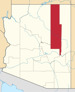
Lake of the Woods is a census-designated place (CDP) in Navajo County, Arizona, United States, adjacent to the town of Pinetop-Lakeside. The population was 4,094 at the 2010 census.
The CDP has a total area of 4.14 square miles (10.7 km2), consisting of 3.96 square miles (10.3 km2) of land and 0.18 square miles (0.47 km2) of water. [3]
Census | Pop. | Note | %± |
---|---|---|---|
2020 | 3,648 | — | |
U.S. Decennial Census [4] |
As of the 2010 census, there were 4,094 people living in the CDP: 2,078 male and 2,016 female. 1,185 were 19 years old or younger, 610 were ages 20–34, 744 were between the ages of 35 and 49, 907 were between 50 and 64, and the remaining 648 were aged 65 and above. The median age was 41.4 years.
The racial makeup of the CDP was 86.1% White, 2.4% American Indian, 0.7% Asian, 0.6% Black or African American, 7.6% Other, and 2.5% two or more races. 19.6% of the population were Hispanic or Latino of any race.
There were 1,607 households in the CDP, 1,093 family households (68.0%) and 514 non-family households (32.0%), with an average household size of 2.54. Of the family households, 815 were married couples living together, while 91 were single fathers and 187 were single mothers; the non-family households included 418 adults living alone: 221 male and 197 female.
The CDP contained 2,859 housing units, of which 1,607 were occupied and 1,252 were vacant. [5]
Round Rock is a Navajo community and census-designated place (CDP) in Apache County, Arizona, United States. The population was 789 at the 2010 census. It is named after a nearby mesa.
Kaibeto is a census-designated place (CDP) in Coconino County, Arizona, United States. The population was 1,522 at the 2010 census.
Munds Park is an unincorporated census-designated place (CDP) in Coconino County, Arizona, United States. The year round population was 631 at the 2010 census.
Parks is a census-designated place (CDP) in Coconino County, Arizona, United States. The population was 1,188 at the 2010 census.
Tonalea is a census-designated place (CDP) in Coconino County, Arizona, United States. The population was 549 at the 2010 census. It has also been known as Red Lake.
Gisela is an unincorporated community and census-designated place (CDP) in Gila County, Arizona, United States. The population was 570 at the 2010 census.
Parker Strip is a census-designated place (CDP) in La Paz County, Arizona, United States. The population was 662 at the 2010 census.
Sun Lakes is an unincorporated community and census-designated place (CDP) in Maricopa County, Arizona, United States. The population was 14,868 at the 2020 census. Sun Lakes is an active adult community comprising five country club communities in three homeowner associations. These include the gated communities of Oakwood and IronWood (IronOaks), the gated and non-gated communities of Palo Verde and Cottonwood, and the non-gated community of Sun Lakes 1. Sun Lakes is a master-planned community developed by Robson Communities.
Desert Hills is an unincorporated community and census-designated place (CDP) in Mohave County, Arizona, United States. The population was 2,764 at the 2020 census, up from 2,245 at the 2010 census.
Corona de Tucson is a census-designated place (CDP) in Pima County, Arizona, United States. The population was 9,240 at the 2020 census, an increase of 1036% from the 2000 population of 813.
Cordes Lakes is a census-designated place (CDP) in Yavapai County, Arizona, United States. The population was 2,058 at the 2000 census. The Agua Fria National Monument lies to the east and south of the community and Arcosanti is to the north.
June Park is a census-designated place (CDP) in Brevard County, Florida. The population was 4,283 at the 2020 United States census, up from 4,094 at the 2010 United States Census. It is part of the Palm Bay–Melbourne–Titusville, Florida Metropolitan Statistical Area.
Pine Lakes is an unincorporated community and census-designated place (CDP) in Lake County, Florida, United States. The population was 862 at the 2010 census, up from 755 at the 2000 census. It is part of the Orlando–Kissimmee Metropolitan Statistical Area.
Lake of the Woods is a census-designated place in Champaign County, Illinois, United States. The population was 2,403 at the 2020 census. Lake of the Woods is located in Mahomet Township and mostly surrounded by the northeast part of the village of Mahomet.
Lost Lake Woods is an unincorporated community and census-designated place (CDP) in Alcona County in the U.S. state of Michigan. The population was 367 at the 2020 census. It is located within Alcona Township.
Buckshot is a census-designated place (CDP) in Yuma County, Arizona, United States. The population was 153 at the 2010 census.
Katherine is an unincorporated community and census-designated place (CDP) in Mohave County, Arizona, United States. The population was 76 at the 2020 census, down from 103 at the 2010 census.
Low Mountain is a census-designated place (CDP) in Navajo County, Arizona, United States. The population was 757 at the 2010 census.
Martinez Lake is a census-designated place (CDP) in Yuma County, Arizona, United States, located on Martinez Lake. The population was 798 at the 2010 census. It was founded in 1958 as a fishing community. It remains primarily a vacation community.
North Fork is a census-designated place (CDP) in Navajo County, Arizona, United States, on the Fort Apache Indian Reservation. The population was 1,417 at the 2010 census.