Low Mountain, Arizona

Last updated

Low Mountain, Arizona
CDP
USA Arizona location map.svg
Red pog.svg
Low Mountain
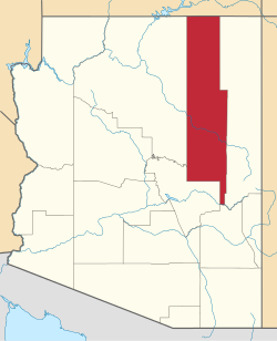
Location within the state of Arizona
Usa edcp location map.svg
Red pog.svg
Low Mountain
Low Mountain (the United States)
Coordinates: 35°56′53″N110°05′53″W / 35.94806°N 110.09806°W / 35.94806; -110.09806
CountryUnited States
State Arizona
County Navajo
Area
[1]
  Total36.90 sq mi (95.58 km2)
  Land36.90 sq mi (95.56 km2)
  Water0.01 sq mi (0.02 km2)
Elevation
[2]
1,880 ft (570 m)
Population
 (2020)
  Total631
  Density17.10/sq mi (6.60/km2)
Time zone UTC-7 (MST)
Area code 928
FIPS code 04-42590
GNIS feature ID2582817

Low Mountain is a census-designated place (CDP) in Navajo County, Arizona, United States. The population was 757 at the 2010 census.

Contents

Geography

Low Mountain is located at 35°56′53″N110°05′53″W / 35.94806°N 110.09806°W / 35.94806; -110.09806 (35.948089, −110.09813). According to the United States Geological Survey, the CDP has a total area of 36.91 square miles (95.6 km2), consisting of 36.9 square miles (96 km2) land and 0.01 square miles (0.026 km2) water. [2] [3]

Demographics

Historical population
CensusPop.Note
2020 631
U.S. Decennial Census [4]

As of the 2010 census, there were 757 people living in the CDP: 386 male and 371 female. 301 were 19 years old or younger, 180 were ages 20–34, 129 were between the ages of 35 and 49, 86 were between 50 and 64, and the remaining 61 were aged 65 and above. The median age was 24.0 years.

The racial makeup of the CDP was 99.1% American Indian, 0.1% White, and 0.8% two or more races. 0.7% of the population were Hispanic or Latino of any race.

There were 189 households in the CDP, 148 family households (78.3%) and 41 non-family households (21.7%), with an average household size of 4.01. Of the family households, 74 were married couples living together, while there were 25 single fathers and 49 single mothers; the non-family households included 34 adults living alone: 20 male and 14 female.

The CDP contained 260 housing units, of which 189 were occupied and 71 were vacant. [5]

Related Research Articles

<span class="mw-page-title-main">Tonalea, Arizona</span> CDP in Coconino County, Arizona

Tonalea is a census-designated place (CDP) in Coconino County, Arizona, United States. The population was 549 at the 2010 census. It has also been known as Red Lake.

<span class="mw-page-title-main">Winslow West, Arizona</span> CDP in Coconino County, Arizona

Winslow West is a census-designated place (CDP) in Coconino and Navajo counties in Arizona, United States. The population was 438 at the 2010 census. The entire community is off-reservation trust land belonging to the Hopi Tribe of Arizona. It lies just west of the city of Winslow, and is more than 50 km (31 mi) south of the main Hopi Reservation.

<span class="mw-page-title-main">Canyon Day, Arizona</span> CDP in Gila County, Arizona

Canyon Day is a census-designated place (CDP) in Gila County, Arizona, United States, on the Fort Apache Indian Reservation. The population was 1,209 at the 2010 census.

<span class="mw-page-title-main">Cibecue, Arizona</span> Fort Apache Indian Reservation community

Cibecue is a census-designated place (CDP) in Navajo County, Arizona, United States, on the Fort Apache Indian Reservation. The population was 1,713 in the 2010 United States Census.

<span class="mw-page-title-main">First Mesa, Arizona</span> CDP in Navajo County, Arizona

First Mesa is a census-designated place (CDP) in Navajo County, Arizona, United States, on the Hopi Reservation. As of the 2010 census, the CDP population was 1,555, spread among three Hopi villages atop the 5,700-foot mesa: Hano, Sitsomovi, and Waalpi.

<span class="mw-page-title-main">Hotevilla-Bacavi, Arizona</span> CDP in Navajo County, Arizona

Hotevilla-Bacavi is a census-designated place (CDP) in Navajo County, Arizona, United States, on the Hopi Reservation. The population was 957 at the 2010 census.

<span class="mw-page-title-main">Jeddito, Arizona</span> CDP in Navajo County, Arizona

Jeddito is a census-designated place (CDP) in Navajo County, Arizona, United States. The population was 293 at the 2010 census.

<span class="mw-page-title-main">Keams Canyon, Arizona</span> CDP in Navajo County, Arizona

Keams Canyon is a census-designated place (CDP) in Navajo County, Arizona, United States, on the Hopi Reservation. The population was 304 at the 2010 census.

<span class="mw-page-title-main">Kykotsmovi Village, Arizona</span> CDP in Navajo County, Arizona

Kykotsmovi Village, also known as K-Town or New Oraibi is a census-designated place (CDP) in Navajo County, Arizona, United States. It is the seat of tribal government of the Hopi Reservation, a sovereign nation located in northeastern Arizona. The Hopi word is spelled Kiqötsmovi and means "mound of ruined houses". The population was 776 at the 2000 census. The Hopi reservation occupies part of Coconino and Navajo counties, encompasses more than 1.5 million acres, and is made up of 12 villages on three mesas. Kykotsmovi is one of the 12 villages located in third mesa. Third Mesa includes Hotvela (Hotevilla), Paaqavi (Bacavi), Munqapi (Moencopi), Kiqotsmovi (Kykotsmovi), and Orayvi (Oraibi).

<span class="mw-page-title-main">Vail, Arizona</span> CDP in Pima County, Arizona

Vail is a census-designated place (CDP) in Pima County, Arizona, United States. It is 24 miles (39 km) southeast of Tucson. The population was 10,208 at the 2010 census, up from 2484 in the 2000 census. The area is known for the nearby Colossal Cave, a large cave system, and the Rincon Mountains District of Saguaro National Park, a top tourism spot within Arizona.

<span class="mw-page-title-main">Winterhaven, California</span> Census-designated place in California, United States

Winterhaven is a census-designated place (CDP) in Imperial County, California. Winterhaven is 6.5 miles (10 km) east of Pilot Knob, The population was 394 at the 2010 census, down from 529 at the 2000 census. It is part of the El Centro, CA Metropolitan Area. North of Interstate 8 and bordering Yuma, Arizona, the town is partly in the Fort Yuma Indian Reservation. The Colorado River marks the town's southern border.

<span class="mw-page-title-main">Sparrowhawk, Oklahoma</span> Census-designated place in Oklahoma, United States

Sparrowhawk is an unincorporated community and census-designated place (CDP) in Cherokee County, Oklahoma, United States. The population was 191 as of the 2010 census, at which time the CDP was known as Scraper. The older name of the community was given for Captain Archibald Scraper of the 2nd Regiment, Indian Home Guard. Sparrowhawk takes its name from Sparrow Hawk Mountain, which occupies most of the CDP.

Hard Rock is a census-designated place (CDP) in Navajo County, Arizona, United States. The population was 94 at the 2010 census.

Hondah is a census-designated place (CDP) in Navajo County, Arizona, United States, on the Fort Apache Indian Reservation. The population was 812 at the 2010 census.

Katherine is an unincorporated community and census-designated place (CDP) in Mohave County, Arizona, United States. The population was 76 at the 2020 census, down from 103 at the 2010 census.

Elephant Head is a census-designated place (CDP) in Pima County, Arizona, United States. The population was 612 at the 2010 census.

North Fork is a census-designated place (CDP) in Navajo County, Arizona, United States, on the Fort Apache Indian Reservation. The population was 1,417 at the 2010 census.

Pimaco Two is a census-designated place (CDP) located in Pima County, Arizona, United States. The population was 682 at the 2010 census.

Pinion Pines is an unincorporated community and census-designated place (CDP) in Mohave County, Arizona, United States. The population was 158 at the 2020 census.

Seba Dalkai is a census-designated place (CDP) located in Navajo County, Arizona, United States. The population was 136 at the 2010 census.

References

  1. "2020 U.S. Gazetteer Files". United States Census Bureau. Retrieved October 29, 2021.
  2. 1 2 "Feature Detail Report for: Low Mountain Census Designated Place". Geographic Names Information System . United States Geological Survey, United States Department of the Interior.
  3. "Low Mountain, Arizona – Basic Facts". AZ Hometown Locator. Retrieved December 19, 2016.
  4. "Census of Population and Housing". Census.gov. Retrieved June 4, 2016.
  5. "American FactFinder: Low Mountain CDP, Arizona". United States Census Bureau. Archived from the original on February 13, 2020. Retrieved December 19, 2016.