
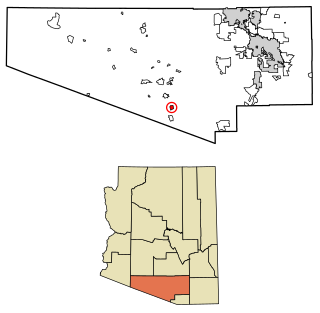
Somerton is a city in Yuma County, Arizona, United States. As of the 2010 census the population was 14,287. It is part of the Yuma Metropolitan Statistical Area.

Alamo is a town in Wheeler County, Georgia, United States. As of the 2020 census, the town had a population of 771. The town is the county seat of Wheeler County.

Toms Brook is a town in Shenandoah County, Virginia, United States. The population was 258 at the 2010 census.

East Globe is a census-designated place in Gila County, Arizona, United States. As of the 2010 census it had a population of 226.

Cedar Creek is a census-designated place in Gila County, Arizona, United States, on the Fort Apache Indian Reservation. Cedar Creek is located along Arizona State Route 73. The population in 2010 was 318.
South Komelik (O'odham) name translates as "South Flat", is a census-designated place in Pima County, in the U.S. state of Arizona. The population was 117 as of the 2020 census. It's located in the southern part of the Tohono O'odham Nation reservation near the border with Mexico.

San Miguel is a census-designated place in Pima County, in the U.S. state of Arizona. The population was 207 as of the 2020 census. San Miguel is located near the border with Mexico on the Tohono O'odham Nation reservation.

Rancho Mesa Verde is a census-designated place and colonia in Yuma County, in the U.S. state of Arizona. The population was 625 at the 2010 census.

Wall Lane is a census-designated place and colonia in Yuma County, in the U.S. state of Arizona. The population was 415 at the 2010 census.

Ventana is a census-designated place in Pima County, in the U.S. state of Arizona. The population was 52 at the 2020 census. The place takes it name from the Spanish word for "window" and is located in the northeastern part of the Tohono O'odham Nation reservation.

Wahak Hotrontk also known as San Simon (O'odham) name translates as "Road Dips", is a census-designated place in Pima County, in the U.S. state of Arizona. The population was 120 as of the 2020 census. It is located along Arizona State Route 86 on the Tohono O'odham Nation reservation.

Willow Canyon is a census-designated place in Pima County, in the U.S. state of Arizona. The population was "S" (Seasonal) at the 2010 census.

Truxton is an unincorporated community and census-designated place (CDP) in Mohave County, in the U.S. state of Arizona. The population was 104 at the 2020 census, down from 134 in 2010.

Sacate Village is a census-designated place in Pinal County, in the U.S. state of Arizona. The population was 169 at the 2010 census.

Upper Santan Village is a census-designated place in Pinal County, in the U.S. state of Arizona. The population was 495 at the 2010 census.

Wet Camp Village is a census-designated place in Pinal County, in the U.S. state of Arizona. The population was 229 at the 2010 census.
Rainbow City is a census-designated place in Navajo County, in the U.S. state of Arizona, on the Fort Apache Indian Reservation. The population was 968 at the 2010 census.

Seven Mile is a census-designated place in Navajo County, in the U.S. state of Arizona, on the Fort Apache Indian Reservation. The population was 707 at the 2010 census.

Tees Toh is a census-designated place in Navajo County, in the U.S. state of Arizona. The population was 448 at the 2010 census.

Turkey Creek is a census-designated place in Navajo County, in the U.S. state of Arizona, on the Fort Apache Indian Reservation. The population was 294 at the 2010 census.


