Brigham City, Arizona

Last updated

Brigham City
BRINGHAM CITY.jpg
USA Arizona location map.svg
Red pog.svg
Brigham City
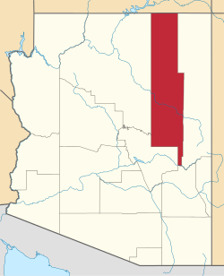
Location in the state of Arizona
Coordinates: 35°02′31″N110°41′04″W / 35.04194°N 110.68444°W / 35.04194; -110.68444
Country Flag of the United States.svg  United States
State Flag of Arizona.svg  Arizona
County Navajo
Founded1876
Abandoned1881
Named for Brigham Young
Elevation
[1]
4,895 ft (1,492 m)
Time zone UTC-7 (MST (no DST))
Area code(s)
Brigham City
USA Arizona location map.svg
Red pog.svg
Usa edcp location map.svg
Red pog.svg
Nearest city Winslow, Arizona
Area160 acres (65 ha)
Built1876
NRHP reference No. 78000558 [2]
Added to NRHPJune 9, 1978

Brigham City is a ghost town in Navajo County, Arizona, United States. Founded by member of the Church of Jesus Christ of Latter-day Saints near the present city of Winslow in 1876, it was one and one-half miles north of Winslow's current city center, along the Little Colorado River. It was organized as a Latter-Day Saints ward in 1878, but by 1881 it had been abandoned. [3] [4]

Contents

Twenty Mormon families and fifteen bachelors from Salt Lake City settled the area, and built homes inside protective walls originally measuring 200 feet (61 m) long and 7 feet (2.1 m) high. Flash flooding that washed away the dams and irrigation systems led to crop failures and caused the abandonment of the town by 1881. [5]

The US Census listed its population as 191 in 1880. [6]

Brigham City was one of four Little Colorado River colonies. [7] The other colonies were Joseph City, Sunset, and Obed. Joseph City is the only remaining colony. [8]

Brigham City was added to the National Register of Historic Places as of June 9, 1978, [9] and the remnants are currently undergoing restoration. [4] Only one of the communities' buildings and portions of the encircling wall remain.

Archaeological excavations have been carried out at the location of the grist mill, the pottery, and other features [10] [11]

Demographics

Brigham City appeared in the U.S. Census in 1880, with a population of 191. [12] The original townsite has since been annexed into the city of Winslow and is now a historic site. [13]

See also

Related Research Articles

<span class="mw-page-title-main">Cameron, Arizona</span> Census-designated place in Coconino County, Arizona, United States

Cameron is a census-designated place (CDP) in Coconino County, Arizona, United States, on the Navajo Nation. The population was 885 at the 2010 census. Most of the town's economy is tourist food and craft stalls, restaurants, and other services for north–south traffic from Flagstaff and Page. There is a ranger station supplying information and hiking permits for the Navajo Nation. There is also a large craft store run by the Nation itself. It is named after Ralph H. Cameron, Arizona's first senator.

<span class="mw-page-title-main">Holbrook, Arizona</span> City in Navajo County, Arizona, US

Holbrook is a city in Navajo County, Arizona, United States. According to the 2010 census, the population of the city was 5,053. The city is the county seat of Navajo County.

<span class="mw-page-title-main">Lot Smith</span> American Mormon pioneer (1830–1892)

Lot Smith was a Mormon pioneer, soldier, lawman and American frontiersman. He became known as "The Horseman" for his exceptional skills on horseback as well as for his help in rounding up wild mustangs on Utah's Antelope Island. He is most famous for his exploits during the 1857 Utah War.

<span class="mw-page-title-main">Brigham Young Jr.</span> American religious leader (1836–1903)

Brigham Young Jr. served as president of the Quorum of the Twelve Apostles of the Church of Jesus Christ of Latter-day Saints from 1899 until his death. His tenure was interrupted for one week in 1901 when Joseph F. Smith was the president of the Quorum.

<span class="mw-page-title-main">Mormon corridor</span> Areas of the western US settled by the LDS Church

The Mormon corridor are the areas of western North America that were settled between 1850 and approximately 1890 by members of the Church of Jesus Christ of Latter-day Saints, who are commonly called "Mormons".

<span class="mw-page-title-main">Mormon colonies in Mexico</span> LDS church settlements in Mexico

The Mormon colonies in Mexico are settlements located near the Sierra Madre mountains in northern Mexico which were established by members of the Church of Jesus Christ of Latter-day Saints beginning in 1885. The colonists came to Mexico due to federal attempts to curb and prosecute polygamy in the United States. Plural marriage, as polygamous relationships were called by church members, was an important tenet of the church—although it was never practiced by a majority of the membership.

<span class="mw-page-title-main">Joseph City, Arizona</span> Unincorporated community in the state of Arizona, United States

Joseph City is a Census Designated Place located in Navajo County, Arizona, United States. It is located on Interstate 40, approximately eighty miles east of Flagstaff and about thirty-five miles west of Petrified Forest National Park. In 2010, there were 1,386 inhabitants.

<span class="mw-page-title-main">Pinedale, Arizona</span> Unincorporated community in the state of Arizona, United States

Pinedale is an unincorporated community in Navajo County, Arizona, United States. The population was 487 at the 2010 census. The elevation is approximately 6,500 ft (2,000 m) and it is part of the Mogollon Rim mountain range.

Seth Benjamin Tanner was a Mormon pioneer, miner, and early settler of Arizona. Tanner Trail in the Grand Canyon National Park was named after him.

<span class="mw-page-title-main">The Church of Jesus Christ of Latter-day Saints in Canada</span>

Since its organization in New York in 1830, The Church of Jesus Christ of Latter-day Saints has had a presence in Canada. The church's first missionaries to preach outside of the United States preached in Upper Canada; the first stake to be established outside of the U.S. was the Alberta Stake; and the Cardston Alberta Temple was the first church temple built outside of the boundaries of the United States.

<span class="mw-page-title-main">Joseph S. Murdock</span> American hymnwriter

Joseph Stacy Murdock was an American colonizer, leader, and Latter-day Saint hymn writer. He wrote the words to "Come Listen to a Prophet's Voice."

<span class="mw-page-title-main">The Church of Jesus Christ of Latter-day Saints in Arizona</span>

The Church of Jesus Christ of Latter-day Saints is the second-largest religious denomination in Arizona, behind the Roman Catholic Church. In 2022, the church reported 439,411 members in Arizona, about 6% of the state's population. According to the 2014 Pew Forum on Religion & Public Life survey, roughly 5% of Arizonans self-identify most closely with the Church of Jesus Christ of Latter-day Saints.

<span class="mw-page-title-main">Criticism of the Book of Mormon</span>

Subjects of criticism of the Book of Mormon include its origins, authenticity, and historicity, which have been subject to considerable criticism from scholars and skeptics since it was first published in 1830. The Book of Mormon is a sacred text of the Latter Day Saint movement, which adherents believe contains writings of ancient prophets who lived on the American continent from approximately 2200 BC to AD 421. It was first published in March 1830 by Joseph Smith as The Book of Mormon: An Account Written by the Hand of Mormon upon Plates Taken from the Plates of Nephi, who said that it had been written in otherwise unknown characters referred to as "reformed Egyptian" engraved on golden plates. Contemporary followers of the Latter Day Saint movement typically regard the text primarily as scripture, but also as a historical record of God's dealings with the ancient inhabitants of the Americas.

Sunset, Arizona is a populated place and former town in Navajo County, Arizona, United States, located approximately four miles north-west of Winslow. It was settled in 1876 by a group of members of the Church of Jesus Christ of Latter-day Saints under the direction of Lot Smith. Drought and flash flooding that washed away the dams and irrigation systems led to crop failures. It ceased being a town by 1884 and the last settlers moved out in 1888. The channel of the Little Colorado River now runs where the town site used to be. Only the small hilltop Sunset Cemetery remains and is part of the Homolovi State Park.

<span class="mw-page-title-main">Obed, Arizona</span> Ghost town in Navajo County, Arizona, US

Obed, Arizona was a town in Navajo County, Arizona located approximately three miles south of Joseph City, Arizona. It was settled in 1876 by a group of members of the Church of Jesus Christ of Latter-day Saints under the direction of George Lake.

<span class="mw-page-title-main">Outline of the Church of Jesus Christ of Latter-day Saints</span> Overview of and topical guide to the Church of Jesus Christ of Latter-day Saints

The following outline is provided as an overview of and a topical guide to the Church of Jesus Christ of Latter-day Saints.

References

  1. U.S. Geological Survey Geographic Names Information System: Brigham City (historical)
  2. "National Register Information System". National Register of Historic Places . National Park Service. March 13, 2009.
  3. Andrew Jenson. Encyclopedic History of the Church. (Salt Lake City: Deseret News Press, 1941). p. 88.
  4. 1 2 "Winslow Chamber of Commerce – Visiting Winslow". Winslowarizona.org. Archived from the original on July 25, 2011. Retrieved July 27, 2010.
  5. "Historic Sites – Brigham City". Arizona Heritage Traveler. Archived from the original on July 7, 2011. Retrieved July 27, 2010.
  6. Moffat, Riley (1996). Population History of Western U.S. Cities and Towns, 1850–1990. Lanham, Maryland: Scarecrow Press, Inc. p. 9. ISBN   0-8108-3033-7.
  7. Tanner, George S and J Morris Richards, Colonization on the Little Colorado: The Joseph City Region (Flagstaff, Arizona: 1977) xiii.
  8. Tanner, George S and J Morris Richards, Colonization on the Little Colorado: The Joseph City Region (Flagstaff, Arizona: 1977) 21, 32, 34.
  9. "NPGallery Digital Asset Management System". Nps.gov. Retrieved October 22, 2017.
  10. Stone, Lyle M. and Gerald A. Doyle & Assoc. 1980 "A Research Report and Restoration Considerations for the Interpretive Development of Historic Resources at Brigham City, A. T. for the City of Winslow, Arizona." ARS, Tempe and Gerald A. Doyle & Associates, Phoenix.
  11. Ferg, Alan 1992 "1991 AAS Excavations at Brigham City and Plans for 1992." The Petroglyph (Arizona Archaeological Society) 28(3):14–15 and 2005 "Brother Behrman’s Pottery." Archaeology Southwest 19(2):7.
  12. "Population of Civil Divisions less than counties, in the aggregate, at the Censuses of 1880 and 1870" (PDF). United States Census Bureau. 1880. p. 99.
  13. "Abandoned in 1881, the Mormon Ghost Town of Brigham City in Arizona Only Lasted 5 Years". May 3, 2019.