Harpersfield, New York | |
---|---|
Coordinates: 42°26′7″N74°40′15″W / 42.43528°N 74.67083°W | |
Country | United States |
State | New York |
County | Delaware |
Government | |
• Type | Town Council |
• Town Supervisor | James E. Eisel (R) |
• Town Council | Members' List |
Area | |
• Total | 42.29 sq mi (109.52 km2) |
• Land | 42.02 sq mi (108.83 km2) |
• Water | 0.27 sq mi (0.69 km2) |
Elevation | 1,824 ft (556 m) |
Population (2020) | |
• Total | 1,442 |
Time zone | UTC-5 (Eastern (EST)) |
• Summer (DST) | UTC-4 (EDT) |
ZIP code | 13786 |
Area code | 607 |
FIPS code | 36-025-32281 |
GNIS feature ID | 0979049 |
Website | www |
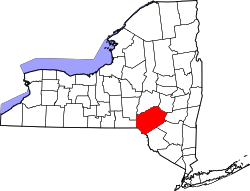
Harpersfield is a town in Delaware County, New York, United States. The population was 1,442 at the 2020 census. [2] [3] The town is on the northern border of the county.
The town was formed in 1768 by Colonel John Harper, who fought for the state of New York during the American Revolutionary War.
The northern town line is the border of Otsego County, while the northeastern town boundary is the border of Schoharie County. The village of Stamford is on the town's southeastern border.
According to the United States Census Bureau, the town has a total area of 42.3 square miles (109.5 km2), of which 42.0 square miles (108.8 km2) is land and 0.3 square miles (0.7 km2), or 0.63%, is water. [3] The northern three-quarters of the town drains westward via Charlotte Creek and several tributaries to the Susquehanna River near Oneonta, while the remainder drains south to the West Branch Delaware River, which forms the south town boundary.
Census | Pop. | Note | %± |
---|---|---|---|
1820 | 1,884 | — | |
1830 | 1,936 | 2.8% | |
1840 | 1,708 | −11.8% | |
1850 | 1,613 | −5.6% | |
1860 | 1,468 | −9.0% | |
1870 | 1,485 | 1.2% | |
1880 | 1,420 | −4.4% | |
1890 | 1,386 | −2.4% | |
1900 | 1,221 | −11.9% | |
1910 | 1,244 | 1.9% | |
1920 | 1,184 | −4.8% | |
1930 | 1,265 | 6.8% | |
1940 | 1,200 | −5.1% | |
1950 | 1,263 | 5.3% | |
1960 | 1,193 | −5.5% | |
1970 | 1,423 | 19.3% | |
1980 | 1,495 | 5.1% | |
1990 | 1,450 | −3.0% | |
2000 | 1,603 | 10.6% | |
2010 | 1,577 | −1.6% | |
2020 | 1,442 | −8.6% | |
U.S. Decennial Census [4] [5] |
As of the census [6] of 2000, there were 1,603 people, 591 households, and 416 families residing in the town. The population density was 38.0 inhabitants per square mile (14.7/km2). There were 913 housing units at an average density of 21.7 per square mile (8.4/km2). The racial makeup of the town was 97.82% White, 0.56% African American, 0.31% Native American, 0.31% Asian, 0.25% from other races, and 0.75% from two or more races. Hispanic or Latino of any race were 2.99% of the population.
There were 591 households, out of which 26.6% had children under the age of 18 living with them, 58.0% were married couples living together, 8.3% had a female householder with no husband present, and 29.6% were non-families. 23.9% of all households were made up of individuals, and 11.3% had someone living alone who was 65 years of age or older. The average household size was 2.48 and the average family size was 2.92.
In the town, the population was spread out, with 21.5% under the age of 18, 6.6% from 18 to 24, 20.4% from 25 to 44, 26.6% from 45 to 64, and 25.0% who were 65 years of age or older. The median age was 46 years. For every 100 females, there were 90.6 males. For every 100 females age 18 and over, there were 89.0 males.
The median income for a household in the town was $33,333, and the median income for a family was $37,446. Males had a median income of $27,237 versus $21,500 for females. The per capita income for the town was $18,863. About 12.5% of families and 18.3% of the population were below the poverty line, including 38.0% of those under age 18 and 7.4% of those age 65 or over.
Westerlo is a town in Albany County, New York, United States. The population was 3,194 at the 2020 census.
Bovina is a town in Delaware County, New York, United States. The population was 658 at the 2020 census. The name "Bovina" was suggested by General Erastus Root, who noted the area's fitness for grazing. Bovina is an interior town in the eastern part of the county.
Colchester is a town in Delaware County, New York, United States. The population was 1,782 at the 2020 census. The town is in the southwestern part of the county.
Hamden is a town in Delaware County, New York, United States. The population was 1,137 at the 2020 census.
Kortright is a town in Delaware County, New York, United States. The population was 1,544 at the 2020 census. The town is in the northern part of the county.
Masonville is a town in Delaware County, New York, United States. The population was 1,239 at the 2020 census. The town is in the western part of the county.
Meredith is a town in Delaware County, New York, United States. The population was 1,484 at the 2020 census. It is an interior town in the northern part of the county.
Tompkins is a town in Delaware County, New York, United States. The population was 1,290 at the 2020 census. The town is named after Daniel D. Tompkins, the fourth governor of New York and sixth vice president of the United States.
Halcott is a town in Greene County, New York, United States. The population was 249 in 2020, down from 258 at the 2010 census. The town is in the southwestern corner of the county.
Prattsville is a town in Greene County, New York, United States. The town is in the northwestern part of the county. As of the 2020 census, the population was 774.
Petersburgh is a town located in the northeast section of Rensselaer County, New York, United States. The population was 1,372 at the 2020 census. The town was named after an early settler named Peter Simmons.
Charlton is a town in Saratoga County, New York, United States. The population was 4,328 at the 2020 census. The town is named after a notable physician.
Carlisle is a town in northern Schoharie County, New York, United States. The population was 1,768 at the 2020 census.
Seward is a town in Schoharie County, New York, United States. The population was 1,583 at the 2020 census. The town is named after senator, governor, and secretary of state William H. Seward.
Wright is a town in Schoharie County, New York, United States. The population was 1,516 at the 2020 census. The town was named after governor Silas Wright.
Olive is a town in Ulster County, New York, United States. The town is west of Kingston, New York, and is inside the Catskill Park. The population was 4,226 at the 2020 census.
Stamford is a town in Delaware County, New York, United States. The population was 2,000 at the 2020 census. The town is in the eastern part of the county and has a village called Stamford.
Walton is a town in Delaware County, New York, United States. The population was 5,270 at the 2020 census. The town is in the west-central part of the county and contains the village of Walton. The town claims to be the "Scarecrow Capital of the World."
Greenville is a hamlet and census-designated place (CDP) in the town of Greenville, in Greene County, New York, United States. The population of the CDP was 688 at the 2020 census, out of a total 3,741 people in the town as a whole.
Plattekill is a town in Ulster County, New York, United States. The population was 10,424 in 2020, a slight decrease from 10,499 at the 2010 census. The name is derived from a stream, the Platte Kill.