Jubilee Pocket, Queensland

Last updated

Jubilee Pocket
Queensland
Caravan park, Jubilee Pocket, 2009.jpg
Caravan park, Jubilee Pocket, 2009
Australia Queensland location map.svg
Red pog.svg
Jubilee Pocket
Coordinates 20°17′28″S148°43′39″E / 20.2911°S 148.7275°E / -20.2911; 148.7275 (Jubilee Pocket (centre of locality))
Population2,047 (2021 census) [1]
 • Density539/km2 (1,395/sq mi)
Postcode(s) 4802
Elevation10–340 m (33–1,115 ft) [2]
Area3.8 km2 (1.5 sq mi)
Time zone AEST (UTC+10:00)
Location
LGA(s) Whitsunday Region
State electorate(s) Whitsunday
Federal division(s) Dawson
Suburbs around Jubilee Pocket:
Airlie Beach Mandalay Mandalay
Cape Conway Jubilee Pocket Cape Conway
Cape Conway Cape Conway Cape Conway

Jubilee Pocket is a residential locality in the Whitsunday Region, Queensland, Australia. [3] In the 2021 census, Jubilee Pocket had a population of 2,047 people. [1]

Contents

Geography

The north and centre of the suburb has lower flatter land used for housing. The more mountainous land around the eastern, southern and western boundaries is undeveloped bushland. [2]

The Proserpine–Shute Harbour Road (State Route 59) enters the locality from the north-west (Airlie Beach), forms part of the northern boundary of the suburb before passing through the locality, and exiting to the north-east (Mandalay ./ Cape Conway). [2]

History

Jubilee Pocket comprises part of the former locality of Jubilee. [3]

Demographics

In the 2016 census, Jubilee Pocket had a population of 1,817 people. [4]

In the 2021 census, Jubilee Pocket had a population of 2,047 people. [1]

Education

There are no schools in Jubilee Pocket. The nearest government primary school is Cannonvale State School in Cannonvale to the north-west. The nearest government secondary school is Proserpine State High School in Proserpine to the south-west. [5]

Amenities

There is a caravan park and camping ground on Shute Harbour Road on the north-western edge of the locality. [6]

Related Research Articles

<span class="mw-page-title-main">Airlie Beach, Queensland</span> Suburb of Whitsunday Region, Queensland, Australia

Airlie Beach is a coastal locality and resort town in the Whitsunday Region of Queensland, Australia. In the 2021 census, Airlie Beach had a population of 1,312 people.

<span class="mw-page-title-main">Shute Harbour</span> Suburb of Whitsunday Region, Queensland, Australia

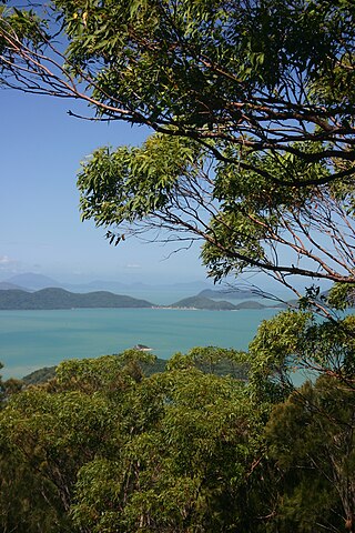
Shute Harbour is a coastal locality and harbour in the Whitsunday Region of Queensland, Australia. It has port facilities and transport options for people seeking to access the Whitsunday Islands and holiday destinations.

<span class="mw-page-title-main">Cannonvale, Queensland</span> Suburb of Whitsunday Region, Queensland, Australia

Cannonvale is a coastal locality and town in the Whitsunday Region, Queensland, Australia. In the 2021 census, Cannonvale had a population of 6,596 people.

Mount Marlow is a rural locality in the Whitsunday Region, Queensland, Australia. In the 2016 census Mount Marlow had a population of 132 people.

Conway is a locality in the Whitsunday Region, Queensland, Australia. In the 2021 census, Conway had a population of 202 people.

Gunyarra is a rural locality in the Whitsunday Region, Queensland, Australia. In the 2021 census, Gunyarra had a population of 30 people.

Hamilton Plains is a rural locality in the Whitsunday Region, Queensland, Australia. In the 2021 census, Hamilton Plains had a population of 80 people.

<span class="mw-page-title-main">Mount Rooper, Queensland</span> Suburb of Whitsunday Region, Queensland, Australia

Mount Rooper is a coastal locality in the Whitsunday Region, Queensland, Australia. In the 2016 census, Mount Rooper had no population.

<span class="mw-page-title-main">Flametree, Queensland</span> Suburb of Whitsunday Region, Queensland, Australia

Flametree is a coastal locality in the Whitsunday Region, Queensland, Australia. In the 2021 census, Flametree had a population of 143 people.

Mandalay is a coastal locality in the Whitsunday Region, Queensland, Australia. In the 2021 census, Mandalay had a population of 338 people.

<span class="mw-page-title-main">Cannon Valley, Queensland</span> Suburb of Whitsunday Region, Queensland, Australia

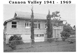
Cannon Valley is a semi-rural locality in the Whitsunday Region, Queensland, Australia. In the 2021 census, Cannon Valley had a population of 1,131 people.

Wilson Beach is a coastal locality in the Whitsunday Region, Queensland, Australia. In the 2021 census, Wilson Beach had a population of 68 people.

<span class="mw-page-title-main">Conway Beach, Queensland</span> Suburb of Whitsunday Region, Queensland, Australia

Conway Beach is a coastal locality in the Whitsunday Region, Queensland, Australia. In the 2021 census, Conway Beach had a population of 75 people.

Woodwark is a coastal locality in the Whitsunday Region, Queensland, Australia. In the 2021 census, Woodwark had a population of 559 people.

<span class="mw-page-title-main">Dingo Beach, Queensland</span> Suburb of Whitsunday Region, Queensland, Australia

Dingo Beach is a coastal rural locality in the Whitsunday Region, Queensland, Australia. In the 2021 census, Dingo Beach had a population of 159 people.

<span class="mw-page-title-main">Hideaway Bay, Queensland</span> Town in Queensland, Australia

Hideaway Bay, also spelled Hydeaway Bay, is a coastal town and locality in the Whitsunday Region, Queensland, Australia. In the 2021 census, the locality of Hideaway Bay had a population of 232 people.

Mount Julian is a rural locality in the Whitsunday Region, Queensland, Australia. In the 2016 census, Mount Julian had a population of 492 people.

Preston is a rural locality in the Whitsunday Region, Queensland, Australia. In the 2021 census, Preston had a population of 346 people.

Whitsunday is a coastal town in the locality of Airlie Beach in the Whitsunday Region, Queensland, Australia.

Proserpine–Shute Harbour Road is a continuous 34.3 kilometres (21.3 mi) road route in the Whitsunday local government area of Queensland, Australia. The route is designated as State Route 59. It is a state-controlled regional road.

References

  1. 1 2 3 Australian Bureau of Statistics (28 June 2022). "Jubilee Pocket (SAL)". 2021 Census QuickStats. Retrieved 28 February 2023. OOjs UI icon edit-ltr-progressive.svg
  2. 1 2 3 "Queensland Globe". State of Queensland . Retrieved 10 November 2018.
  3. 1 2 "Jubilee Pocket – locality in Whitsunday Region (entry 46879)". Queensland Place Names. Queensland Government . Retrieved 9 November 2018.
  4. Australian Bureau of Statistics (27 June 2017). "Jubilee Pocket (SSC)". 2016 Census QuickStats. Retrieved 20 October 2018. OOjs UI icon edit-ltr-progressive.svg
  5. "Layers: Locality; Schools and school catchments". Queensland Globe. Queensland Government. Archived from the original on 19 December 2017. Retrieved 30 September 2023.
  6. "Adventure Whitsunday Resort". BIG 4 Holiday Parks. Archived from the original on 10 November 2018. Retrieved 10 November 2018.

Commons-logo.svg Media related to Jubilee Pocket, Queensland at Wikimedia Commons