K'atepan

Last updated
K'atepan, as seen from across the valley K'atepan 01.png
K'atepan, as seen from across the valley

K'atepan (pronounced [kʼate'pan]), also known as Yolchonab' (pronounced [joltʃo'naɓ]), is an archaeological site of the ancient Maya civilization located 1 kilometre (0.62 mi) to the east of the modern town of San Mateo Ixtatán, in the Huehuetenango Department of Guatemala. [1] The name K'atepan translates as "old church", while the alternate name of Yolchonab' means "in the village". [2] The site consists of a small temple plaza in front of two large terraces set against a mountainside, accessed by broad stairways. [2] The site was first described by Guatemalan historian Adrián Recinos in 1913. Recinos considered K'atepan to be the most important ceremonial site in the northern Sierra de los Cuchumatanes mountains. [2] A preliminary map of K'atepan was produced in 2007. [3]

Maya civilization Mesoamerican civilization

The Maya civilization was a Mesoamerican civilization developed by the Maya peoples, and noted for its logosyllabic script—the most sophisticated and highly developed writing system in pre-Columbian Americas—as well as for its art, architecture, mathematics, calendar, and astronomical system. The Maya civilization developed in an area that encompasses southeastern Mexico, all of Guatemala and Belize, and the western portions of Honduras and El Salvador. This region consists of the northern lowlands encompassing the Yucatán Peninsula, and the highlands of the Sierra Madre, running from the Mexican state of Chiapas, across southern Guatemala and onwards into El Salvador, and the southern lowlands of the Pacific littoral plain.

San Mateo Ixtatán Municipality in Huehuetenango, Guatemala

San Mateo Ixtatán is a municipality in the Guatemalan department of Huehuetenango. It is situated at 2,540 metres (8,330 ft) above sea level in the Cuchumatanes mountain range and covers 560 square kilometres (220 sq mi) of terrain. It has a cold climate and is located in a cloud forest. The temperature fluctuates between 0.5 and 20 °C. The coldest months are from November to January and the warmest months are April and May. The town has a population of about 10,000, and is the municipal center for an additional 20,000 people living in the surrounding mountain villages. It has a weekly market on Thursday and Sunday. The annual town festival takes place from September 19 to September 21 honoring their patron Saint Matthew. The residents of San Mateo belong to the Chuj Maya ethnic group and speak the Mayan Chuj language, not to be confused with Chuj baths, or wood fired steam rooms that are common throughout the central and western highlands.

Huehuetenango Department Department in Huehuetenango, Guatemala

Huehuetenango is one of the 22 departments of Guatemala. It is situated in the western highlands and shares borders with Mexico in the north and west; with El Quiché in the east, with Totonicapán, Quetzaltenango, and San Marcos to the south. The capital is the city of Huehuetenango.

Contents

Description

Plan of the site core K'atepan plan.png
Plan of the site core

K'atepan possesses 19 structures clustered in six architectural groups. [4] The main temple measures 8 by 13.5 by 2.5 metres (26.2 by 44.3 by 8.2 ft) and stands in the centre of a small plaza. Although it is located on an exposed mountainside, it is relatively well preserved. [2] It does not appear to have been badly damaged by looting though there are some small holes on the northeastern side. [5] The temple has suffered some damage in recent times from plant roots penetrating the masonry. [2] A substantial portion of the southeastern corner of the temple has collapsed, revealing a substructure with finely cut stonework, perhaps belonging to its stairway. The temple was coated with various layers of stucco; the outermost layer remains intact over much of the temple exterior. When Recinos published his description in the early 20th century, photographs showed the temple in a much better state of preservation, with standing walls from the temple shrine upon its summit. [6]

Stucco material made of aggregates, a binder, and water

Stucco or render is a material made of aggregates, a binder, and water. Stucco is applied wet and hardens to a very dense solid. It is used as a decorative coating for walls and ceilings, and as a sculptural and artistic material in architecture. Stucco may be used to cover less visually appealing construction materials, such as metal, concrete, cinder block, or clay brick and adobe.

The temple is of a style typical of the Postclassic period (c. 950–1539 AD) in the Guatemalan Highlands. The northeastern side of the temple was accessed by a double stairway, with a single stairway on each of the other sides. Directly opposite the double stairway, another double stairway climbs the lower platform of the two terraces. On the southeastern side, the single stairway is matched by a single stairway in a platform opposite. The temple and the platform are not perfectly aligned, but there appears to have been an attempt to produce general symmetry. [6]

Guatemalan Highlands upland region in southern Guatemala, lying between the Sierra Madre de Chiapas to the south and the Petén lowlands to the north; made up of a series of high valleys enclosed by mountains

The Guatemalan Highlands is an upland region in southern Guatemala, lying between the Sierra Madre de Chiapas to the south and the Petén lowlands to the north. The highlands are made up of a series of high valleys enclosed by mountains. The local name for the region is Altos, meaning "highlands", which includes the northern declivity of the Sierra Madre. The mean elevation is greatest in the west and least in the east. A few of the streams of the Pacific slope actually rise in the highlands, and force a way through the Sierra Madre at the bottom of deep ravines. One large river, the Chixoy or Salinas River, escapes northwards towards the Gulf of Mexico. The relief of the mountainous country which lies north of the Highlands and drains into the Atlantic is varied by innumerable terraces, ridges and underfalls; but its general configuration is compared by E. Reclus with the appearance of "a stormy sea breaking into parallel billows". The parallel ranges extend east and west with a slight southerly curve towards their centres. A range called the Sierra de Chamá, which, however, changes its name frequently from place to place, strikes eastward towards Belize, and is connected by low hills with the Cockscomb Mountains; another similar range, the Sierra de Santa Cruz, continues east to Cape Cocoli between the Polochic and the Sarstoon; and a third, the Sierra de las Minas or, in its eastern portion, Sierra del Mico, stretches between the Polochic and the Motagua rivers. Between Honduras and Guatemala, the frontier is formed by the Sierra de Merendón.

The surveyed architecture consisting of the temple plaza and associated platforms is apparently the core of a larger group of buildings. Investigators highlighted overgrown buildings further down the mountainside, the dimensions of which suggest another temple similar in size and design to the central temple. A small platform is located up the slope to the southeast, beside a road, and there are likely to be further remains as yet undescribed. [6]

The architectural style of the K'atepan temple is very similar to that of the remains of a pre-Columbian temple at Titz'am, the nearby salt springs in the valley below, [7] and the two sites are closely linked in local tradition. [8]

Folklore

In local tradition, the site is linked to the Tojolabal Maya, and is said to have belonged to an ancient lord. [6] Tradition holds that K'atepan was the home of the Tzapaluta people, [9] the local name for the Tojolabal, [6] and the former name of La Trinitaria in Chiapas, in neighbouring Mexico. [10] It is generally not considered to be sacred by the modern Chuj Maya inhabitants of San Mateo Ixtatán. The Tojolabal Maya are said to have been expelled from the area by the Chuj after a war over the local salt springs. The Tojolabal are now located in Chiapas, and they have a tradition that they originally came from the San Mateo Ixtatán region; they make yearly pilgrimages to San Mateo to pray for rain. Originally these pilgrimages were to K'atepan, but in recent times the focus has moved across the valley to San Mateo, the neighbouring ruins of Wajxaklajun, and the local salt springs. [6] By 2013, the organisation of these traditional pilgrimages was carried out by Tzeltal Maya of La Trinitaria, but still included ethnic Tojolabal. [11] The Tzeltal participants have no traditions concerning K'atepan. [12]

La Trinitaria, Chiapas Municipality in Chiapas, Mexico

La Trinitaria is a town and one of the 119 Municipalities of Chiapas, in southern Mexico.

Chiapas State of Mexico

Chiapas, officially the Free and Sovereign State of Chiapas, is one of the 31 states that along with the federal district of Mexico City make up the 32 federal entities of Mexico. It is divided into 124 municipalities as of September 2017 and its capital city is Tuxtla Gutiérrez. Other important population centers in Chiapas include Ocosingo, Tapachula, San Cristóbal de las Casas, Comitán and Arriaga. It is the southernmost state in Mexico. It is located in Southeastern Mexico, and it borders the states of Oaxaca to the west, Veracruz to the northwest and Tabasco to the north, and by the Petén, Quiché, Huehuetenango and San Marcos departments of Guatemala to the east and southeast. Chiapas has a coastline along the Pacific Ocean to the south.

Mexico Country in the southern portion of North America

Mexico, officially the United Mexican States, is a country in the southern portion of North America. It is bordered to the north by the United States; to the south and west by the Pacific Ocean; to the southeast by Guatemala, Belize, and the Caribbean Sea; and to the east by the Gulf of Mexico. Covering almost 2,000,000 square kilometres (770,000 sq mi), the nation is the fifth largest country in the Americas by total area and the 13th largest independent state in the world. With an estimated population of over 120 million people, the country is the eleventh most populous state and the most populous Spanish-speaking state in the world, while being the second most populous nation in Latin America after Brazil. Mexico is a federation comprising 31 states and Mexico City, a special federal entity that is also the capital city and its most populous city. Other metropolises in the state include Guadalajara, Monterrey, Puebla, Toluca, Tijuana and León.

Notes

  1. Wölfel and Frühsorge 2008, pp. 86–87. Straffi 2013, p. 257 n24.
  2. 1 2 3 4 5 Wölfel and Frühsorge 2008, p. 89.
  3. Wölfel and Frühsorge 2008, p. 91.
  4. Straffi 2013, p. 257. n24.
  5. Wölfel and Frühsorge 2008, pp. 89–90.
  6. 1 2 3 4 5 6 Wölfel and Frühsorge 2008, p. 90.
  7. Wölfel and Frühsorge 2008, pp. 87, 92.
  8. Wölfel and Frühsorge 2008, p. 92.
  9. MINEDUC 2001, p. 18.
  10. Cuadriello Olivos and Megchún Rivera 2006, p. 31.
  11. Straffi 2013, p. 257.
  12. Straffi 2013, pp. 261–262.

Related Research Articles

Tohil

Tohil was a deity of the Kʼicheʼ Maya in the Late Postclassic period of Mesoamerica.

Mayan languages language family spoken in Mesoamerica

The Mayan languages form a language family spoken in Mesoamerica and northern Central America. Mayan languages are spoken by at least 6 million Maya peoples, primarily in Guatemala, Mexico, Belize and Honduras. In 1996, Guatemala formally recognized 21 Mayan languages by name, and Mexico recognizes eight more within its territory.

Zaculeu archaeological site in Guatemala

Zaculeu or Saqulew is a pre-Columbian Maya archaeological site in the highlands of western Guatemala, about 3.7 kilometres (2.3 mi) outside of the modern city of Huehuetenango. Occupation at the site dates to the Early Classic period (AD 250–600) of Mesoamerican history. Zaculeu was the capital of the Postclassic Mam kingdom, and was conquered by the K'iche' Kingdom of Q'umarkaj. It displays a mixture of Mam and K'iche' style architecture.

Qʼumarkaj capital city of the pre-Columbian Kiche Maya of highland Guatemala.

Qʼumarkaj, is an archaeological site in the southwest of the El Quiché department of Guatemala. Qʼumarkaj is also known as Utatlán, the Nahuatl translation of the city's name. The name comes from Kʼicheʼ Qʼumarkah "Place of old reeds".

Mixco Viejo human settlement

Mixco Viejo, occasionally spelt Mixcu Viejo, is an archaeological site in the north east of the Chimaltenango department of Guatemala, some 50 kilometres (31 mi) to the north of Guatemala City and 4 kilometres (2.5 mi) from the junction of the rivers Pixcaya and Motagua. It is a moderate sized ruined city of the Postclassic Maya civilization.

Spanish conquest of Guatemala protracted conflict during the Spanish colonization of the Americas, in which Spanish colonisers gradually incorporated the territory that became the modern country of Guatemala into the colonial Viceroyalty of New Spain

The Spanish conquest of Guatemala was a protracted conflict during the Spanish colonization of the Americas, in which Spanish colonisers gradually incorporated the territory that became the modern country of Guatemala into the colonial Viceroyalty of New Spain. Before the conquest, this territory contained a number of competing Mesoamerican kingdoms, the majority of which were Maya. Many conquistadors viewed the Maya as "infidels" who needed to be forcefully converted and pacified, disregarding the achievements of their civilization. The first contact between the Maya and European explorers came in the early 16th century when a Spanish ship sailing from Panama to Santo Domingo was wrecked on the east coast of the Yucatán Peninsula in 1511. Several Spanish expeditions followed in 1517 and 1519, making landfall on various parts of the Yucatán coast. The Spanish conquest of the Maya was a prolonged affair; the Maya kingdoms resisted integration into the Spanish Empire with such tenacity that their defeat took almost two centuries.

Nentón Place in Huehuetenango, Guatemala

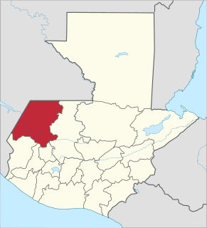
Nentón is a municipality in the Guatemalan department of Huehuetenango. Its territory extends 762.85 km2 and has 9,113 inhabitants. It became a municipality on December 5, 1876 and was formerly known as San Benito Nentón. The population here speaks Spanish and Chuj.

San Sebastián Coatán Municipality in the Guatemalan department of Huehuetenango

San Sebastián Coatán is a municipality in the Guatemalan department of Huehuetenango. Its territory extends 560 km2, is 2,350m above sea level and has a cooler climate. It has 18,022 inhabitants who speak Spanish and Chuj. It borders San Mateo Ixtatán and Nentón to the north, San Rafael la Independencia and Santa Eulalia to the east, San Miguel Acatán to the south and Nentón to the west. Within these borders lies the archeological site called Moja'.

Chuj is a Mayan language spoken by around 40,000 members of the Chuj people in Guatemala and around 3,000 members in Mexico. Chuj is a member of the Qʼanjobʼalan branch along with the languages of Tojolabʼal, Qʼanjobʼal, Akateko, Poptiʼ, and Mochoʼ which, together with the Chʼolan branch, Chuj forms the Western branch of the Mayan family. The Chujean branch emerged approximately 2,000 years ago. In Guatemala, Chuj speakers mainly reside in the municipalities of San Mateo Ixtatán, San Sebastián Coatán and Nentón in the Huehuetenango Department. Some communities in Barillas and Ixcán also speak Chuj. The two main dialects of Chuj are the San Mateo Ixtatán dialect and the San Sebastián Coatán dialect.

Iximche human settlement

Iximcheʼ is a Pre-Columbian Mesoamerican archaeological site in the western highlands of Guatemala. Iximche was the capital of the Late Postclassic Kaqchikel Maya kingdom from 1470 until its abandonment in 1524. The architecture of the site included a number of pyramid-temples, palaces and two Mesoamerican ballcourts. Excavators uncovered the poorly preserved remains of painted murals on some of the buildings and ample evidence of human sacrifice. The ruins of Iximche were declared a Guatemalan National Monument in the 1960s. The site has a small museum displaying a number of pieces found there, including sculptures and ceramics. It is open daily.

Xpuhil

Xpuhil Pronounced:/ʃpuχil̥/ is a Maya archaeological site located in the Mexican state of Campeche, in the vicinity of the modern-day town of Xpujil. The area surrounding Xpuhil, along Federal Highway 186, is rich with other Maya sites, including Becan and Calakmul. The name xpuhil means "cat's tail" in reference to a type of vegetation found locally.

The Chuj or Chuh are a Maya people, whose homeland is in Guatemala and Mexico. Population estimates vary between 30,000 and over 60,000. Their indigenous language is also called Chuj and belongs to the Q'anjobalan branch of Mayan languages. In Guatemala, most Chuj live in the department of Huehuetenango in the municipalities of San Mateo Ixtatán and San Sebastián Coatán.

Spanish conquest of the Maya Conquest dating from 1511 to 1697

The Spanish conquest of the Maya was a protracted conflict during the Spanish colonisation of the Americas, in which the Spanish conquistadores and their allies gradually incorporated the territory of the Late Postclassic Maya states and polities into the colonial Viceroyalty of New Spain. The Maya occupied a territory that is now incorporated into the modern countries of Mexico, Guatemala, Belize, Honduras and El Salvador; the conquest began in the early 16th century and is generally considered to have ended in 1697.

Awilix

Awilix was a goddess of the Postclassic Kʼicheʼ Maya, who had a large kingdom in the highlands of Guatemala. She was the patron deity of the Nijaʼibʼ noble lineage at the Kʼicheʼ capital Qʼumarkaj, with a large temple in the city. Awilix was a Moon goddess and a goddess of night, although some studies refer to the deity as male. Awilix was probably derived from the Classic period lowland Maya moon goddess or from Cʼabawil Ix, the Moon goddess of the Chontal Maya.

The Tzeltal are a Maya people of Mexico, who chiefly reside in the highlands of Chiapas. The Tzeltal language belongs to the Tzeltalan subgroup of Maya languages. Most Tzeltals live in communities in about twenty municipalities, under a Mexican system called “usos y costumbres” which seeks to respect traditional indigenous authority and politics. Women are often seen wearing traditional huipils and black skirts, but men generally do not wear traditional attire. Tzeltal religion syncretically integrates traits from Catholic and native belief systems. Shamanism and traditional medicine is still practiced. Many make a living through agriculture and/or handcrafts, mostly textiles; and many also work for wages to meet family needs.

Wajxaklajun

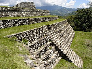
Wajxaklajun is a ruin of the ancient Maya civilization situated adjacent to the modern town of San Mateo Ixtatán, in the Huehuetenango Department of Guatemala. Wajxaklajun is considered to be the most important archaeological site in the San Mateo Ixtatán area. The site has been dated to the Classic period. The Chuj Maya consider the city to have been built by their ancestors. The site has similarities with other nearby highland Maya ruins; it is unusual for the presence of a number of stelae, a feature more associated with lowland sites during the Classic period, probably indicating some level of exchange with lowland cities.

References

Cuadriello Olivos, Hadlyyn; and Rodrigo Megchún Rivera. Tojolabales . Pueblos indígenas del México contemporáneo (in Spanish). Mexico City, Mexico: Comisión Nacional para el Desarollo de los Pueblos Indígenas. ISBN   970-753-051-0. OCLC   137295493. Archived from the original on 2015-01-28. (in Spanish)
MINEDUC (2001). Eleuterio Cahuec del Valle, ed. Historia y Memorias de la Comunidad Étnica Chuj (PDF) II (Versión escolar ed.). Guatemala: Universidad Rafael Landívar/UNICEF/FODIGUA. Archived from the original (PDF) on 2009-02-05. (in Spanish)
Straffi, Enrico (2013) Interpretaciones mayas de los sitios arqueológicos: un análisis (in Spanish) In Cairo Carou, Heriberto; Cabezas González, Almudena; Mallo Gutiérrez, Tomás; Campo García, Esther del; Carpio Martín, José. XV Encuentro de Latinoamericanistas Españoles, Nov 2012, Madrid, Spain: Trama editorial; CEEIB, pp.252–271, 2013. <halshs-00873762> (in Spanish)
Wölfel, Ulrich; and Lars Frühsorge (August 2008) Archaeological Sites near San Mateo Ixtatán: Hints at Ethnic Plurality Mexicon. (Mexicon) 30 (4):86–93. JSTOR   23759262. (subscription required)

Coordinates: 15°50′07″N91°28′07″W / 15.835341°N 91.468562°W / 15.835341; -91.468562